- Home
- :
- All Communities
- :
- Products
- :
- ArcGIS Online
- :
- ArcGIS Online Questions
- :
- Coordinates issue when reprojecting
- Subscribe to RSS Feed
- Mark Topic as New
- Mark Topic as Read
- Float this Topic for Current User
- Bookmark
- Subscribe
- Mute
- Printer Friendly Page
Coordinates issue when reprojecting
- Mark as New
- Bookmark
- Subscribe
- Mute
- Subscribe to RSS Feed
- Permalink
- Report Inappropriate Content
We have a public web map http://crimpr.maps.arcgis.com/home/item.html?id=cec3e72c8ab548ba90ec9954332f107f which base map was created in State Plane NAD83. Althought we can use other base maps in AGOL, we identified an issue when capturing coordinates with the measure tool. It looks like is something regarding the "reprojection" calculation done by AGOL to provide the coordinates value.
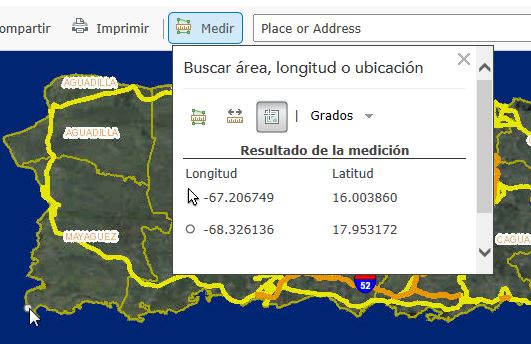
As you see, when clicked in the map the longitude value changes dramatically of the actual cursor position. In the latitude value is viceversa...when clicked in the map the value looks correct, but the cursor position is not (it doesn't even changes). I other words, in the example provided, the correct coordinates values are the cursor position for longitude and the clicked position for the latitude.
I believed this might be an error of how AGOL deals with the mentioned map.
- Mark as New
- Bookmark
- Subscribe
- Mute
- Subscribe to RSS Feed
- Permalink
- Report Inappropriate Content
This appears to be a bug. I've written it up so we can get it fixed.
Thanks,
Mike