- Home
- :
- All Communities
- :
- Products
- :
- ArcGIS Explorer Desktop (Retired)
- :
- ArcGIS Explorer Desktop Questions
- :
- How to remove RasterLayer gray edge
- Subscribe to RSS Feed
- Mark Topic as New
- Mark Topic as Read
- Float this Topic for Current User
- Bookmark
- Subscribe
- Mute
- Printer Friendly Page
How to remove RasterLayer gray edge
- Mark as New
- Bookmark
- Subscribe
- Mute
- Subscribe to RSS Feed
- Permalink
- Report Inappropriate Content
Hello , I add a RasterLayer from JPG file , but there is a gray edge on this RasterLayer picture , how to remove the gray edge ? Thanks .
- Mark as New
- Bookmark
- Subscribe
- Mute
- Subscribe to RSS Feed
- Permalink
- Report Inappropriate Content
screen grab? perhaps it is just the nodata area if the image is slightly rotated. You will have to check the symbology for the layer to confirm
- Mark as New
- Bookmark
- Subscribe
- Mute
- Subscribe to RSS Feed
- Permalink
- Report Inappropriate Content
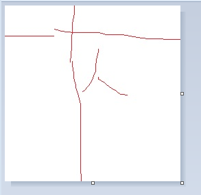
This is screen grab , I want remove these four gray lines . Thanks.

- Mark as New
- Bookmark
- Subscribe
- Mute
- Subscribe to RSS Feed
- Permalink
- Report Inappropriate Content
It looks like the image was acquired with a border around it, where did it originate from? Since you are using arcexplorer, there are no image processing capabilities there so you may have to live with it unless you have access to other software which will retain any image georeferencing. If it isn't a georeferenced image, just bring it into a image package and crop it a bit
- Mark as New
- Bookmark
- Subscribe
- Mute
- Subscribe to RSS Feed
- Permalink
- Report Inappropriate Content
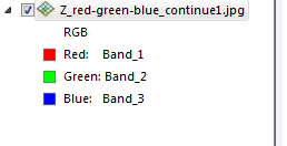
This is the RasterLayer.
- Mark as New
- Bookmark
- Subscribe
- Mute
- Subscribe to RSS Feed
- Permalink
- Report Inappropriate Content
if you have ArcMap, export the file using a smaller extent so that the border is clipped off...In arcexplorer...well, all it is an explorer and lacks functionality to do what you want
- Mark as New
- Bookmark
- Subscribe
- Mute
- Subscribe to RSS Feed
- Permalink
- Report Inappropriate Content
Thanks your anser . This is my picture in photo shop , it has not gray edge , but adding in ArcGIS Explorer , these is gray edge . I do not want this gray edge .
- Mark as New
- Bookmark
- Subscribe
- Mute
- Subscribe to RSS Feed
- Permalink
- Report Inappropriate Content
I hope use ArcGIS Explorer only , do not want use ArcMap.
- Mark as New
- Bookmark
- Subscribe
- Mute
- Subscribe to RSS Feed
- Permalink
- Report Inappropriate Content
check your photo shop options then...I use this technique in SnagIt occasionally to remove collars ensuring that there is no bounding outline when I save the image
- Mark as New
- Bookmark
- Subscribe
- Mute
- Subscribe to RSS Feed
- Permalink
- Report Inappropriate Content
I have had good success with using the option to set a transparency color. (Tools, Appearance, Set Transparent Color, then click on the area you don't want drawn. Whatever color that pixel is won't be drawn for the rest of the image. Nice way to get rid of collars on images.