- Home
- :
- All Communities
- :
- Products
- :
- ArcGIS Online
- :
- ArcGIS Online Questions
- :
- ArcGIS Online Feature Class Issues
- Subscribe to RSS Feed
- Mark Topic as New
- Mark Topic as Read
- Float this Topic for Current User
- Bookmark
- Subscribe
- Mute
- Printer Friendly Page
ArcGIS Online Feature Class Issues
- Mark as New
- Bookmark
- Subscribe
- Mute
- Subscribe to RSS Feed
- Permalink
- Report Inappropriate Content
Hello everyone. My name is Jacob Perez. I am a senior GIS student at Southern Utah University and will be graduating in May. I have been playing around with the ArcGIS online to see if it can be used by the Facilities Management here at SUU, they would like to use it for room inventory.
I started working on this project during the summer and am self taught when it comes to the ArcGIS online feature.
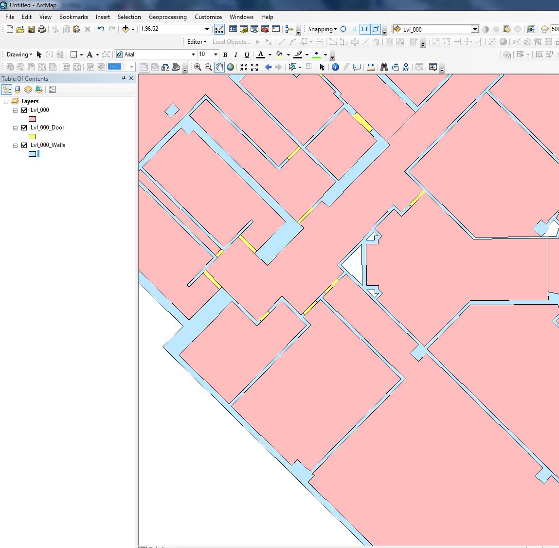
So the issue I am running into is when I share feature classes of SUU Campus and open them in the ArcGIS online map none of them line up correctly. Issue_1 JPG is a screen capture of ArcMap and how the building should look. The color scheme is just to be able to see it easier. Red = Rooms, Blue = Walls, Yellow = Doors.
Issue_2 JPG shows what the end product looks like in ArcGIS online map.
First thought would be a coordinate system or projection issue but to my knowledge everything is set up properly prior to uploading it to the server.
Any suggestions or help would be greatly appreciated.
Jacob Perez.
- Mark as New
- Bookmark
- Subscribe
- Mute
- Subscribe to RSS Feed
- Permalink
- Report Inappropriate Content
Hi Jacob,
This looks to be a projection issue. What is the projection of your basemap service, q75ut8309jshp? For the most accurate results and best performance, your other services should be in the same coordinate system as your basemap.
- Mark as New
- Bookmark
- Subscribe
- Mute
- Subscribe to RSS Feed
- Permalink
- Report Inappropriate Content
Hello Jake,
Thank you for responding so quickly to my question. The base map that I am using was a last ditch effort to be able to zoom in past the zoom restriction ArcGIS online has. After some research a youtube video suggested trying to add a new base map from the Data.gov webpage that didn't have that same restriction. Good thing is that it worked and I am able to zoom in as close as I need which is need for this project.
Utah 7.5' USGS Quad Index - Web Mapping Service - Data.gov
But after adding the walls and doors to a new map with the OpenStreetMap basemap and changing their colors to bright reds and yellows the problem isn't visible.
So I would assume that when I am adding data with this Utah 7.5" USGS Quad Index as a base map that it might have a tolerance pre set that is making everything go screwy?
- Mark as New
- Bookmark
- Subscribe
- Mute
- Subscribe to RSS Feed
- Permalink
- Report Inappropriate Content
It looks like the coordinate system of the Utah 7.5" WMS layer is WGS 84. When adding this as a basemap, the coordinate system of the map will be set to WGS 84. What is the coordinate system of your ArcGIS Online hosted feature service layer?
- Mark as New
- Bookmark
- Subscribe
- Mute
- Subscribe to RSS Feed
- Permalink
- Report Inappropriate Content
Sorry for the late response, my wife had a grad school interview this week and we have been traveling. My coordinate system for the hosted feature is NAD_1983_StatePlane_Utah_South_FIPS_4303_Feet.
- Mark as New
- Bookmark
- Subscribe
- Mute
- Subscribe to RSS Feed
- Permalink
- Report Inappropriate Content
Add the data for the hosted feature service to ArcMap and set the data frame to WGS_84. You will want to apply a transformation since the datums are different. Then, upload and overwrite the previous hosted feature service. Is the issue still reproducible?
- Mark as New
- Bookmark
- Subscribe
- Mute
- Subscribe to RSS Feed
- Permalink
- Report Inappropriate Content
I have tried this with the transformation and re-uploading and I am still getting the same issue. But the reason is that base map I have been using. When I use just a normal ESRI base map the walls stay put but the moment i change it, it goes all screwy. The purpose of the project is for field verification and in order for it to work properly we will need to be able to zoom in to be able to see individual rooms.