- Home
- :
- All Communities
- :
- Products
- :
- Imagery and Remote Sensing
- :
- Imagery Questions
- :
- Question about Mosaic Dataset
- Subscribe to RSS Feed
- Mark Topic as New
- Mark Topic as Read
- Float this Topic for Current User
- Bookmark
- Subscribe
- Mute
- Printer Friendly Page
Question about Mosaic Dataset
- Mark as New
- Bookmark
- Subscribe
- Mute
- Subscribe to RSS Feed
- Permalink
- Report Inappropriate Content
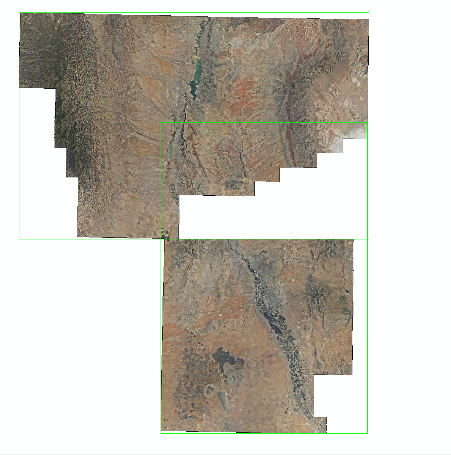
I am trying to mosaic these two NAIP imagery into Mosaic Dataset and how do I make them work ?
You see the green boundary that need to be correct
- Mark as New
- Bookmark
- Subscribe
- Mute
- Subscribe to RSS Feed
- Permalink
- Report Inappropriate Content
As I am trying to figure it out I have worked on it however I still have not resolve the "blocks" when you mosaic them.
- Mark as New
- Bookmark
- Subscribe
- Mute
- Subscribe to RSS Feed
- Permalink
- Report Inappropriate Content
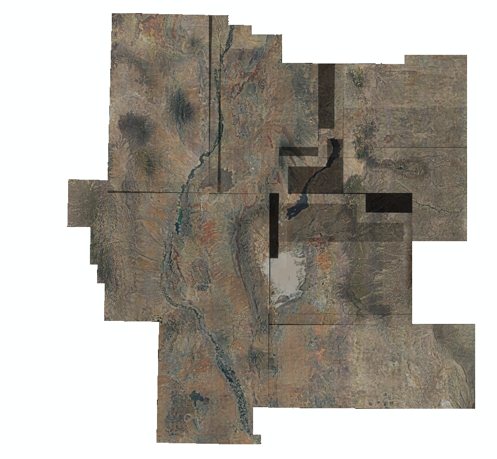
it is common to see your snapshot (above), when mosaicing different images with 'black edges' or some of pan-sharpened images, where Pan extent /boundary is inconsistnt with multiple-spectral boundary...
You can try the following to fix:
1. Via manually editing Footprints, you can remove the 'blacks' parts in MD (in the second snapshot);
2. Via automatically building Footprints (spectral...), you can shrink and correct the boundary of each raster (in the first snapshot)...
- Mark as New
- Bookmark
- Subscribe
- Mute
- Subscribe to RSS Feed
- Permalink
- Report Inappropriate Content
You try following steps:
1. Create a mosaic dataset using all the images (do not build overviews)
2. Run Build footprint tool using Number of vertices to -1
3. Run Build overviews
Hope this helps
Kishor
- Mark as New
- Bookmark
- Subscribe
- Mute
- Subscribe to RSS Feed
- Permalink
- Report Inappropriate Content
Kishor,
Thanks, I did however figured it out the problem when I tired the same thing for 2011 and 2014 because the one I post above did not have what I need.
So, when I found out I worked on and been trying t o figure it out...see here what I did.
The one you see above the picture is in the year of 2009 and I did not have enough additional imagery so I had to get some more from my another co-worker.
I will plan on do the same thing when I have the time.
Thanks all !
- Mark as New
- Bookmark
- Subscribe
- Mute
- Subscribe to RSS Feed
- Permalink
- Report Inappropriate Content
Did you try changing the mosaic operator? If you have images with black borders you can set the mosaic operator to MAX and it will pick the lightest pixel in overlapping pixels. You can play around with different operators to see which looks best.
- Mark as New
- Bookmark
- Subscribe
- Mute
- Subscribe to RSS Feed
- Permalink
- Report Inappropriate Content
Alexis
That's a creative answer, and a good setting to know about, but I 'm confident you'll find a LOT of bright pixels 'bleeding through' from below that will provide a noisy and unsatisfactory result.
The best solution for this is proper use of footprints, such that everything outside the footprint is ignored (set mosaic dataset property "clip to footprints?" = yes). Defining a NoData value of 0 does not work well because the NAIP county compressed mosaics are wavelet compressed (MrSID or JP2000) and there are a lot of black pixels with values = 1 or 2. The zero pixels will be hidden as NoData, but the other black pixels will create an annoying noisy image that will change at different zoom levels.
We published detailed discussion of this in the Image Management Guidebook along with example scripts (and sample data, including NAIP) that you can download from this Group on ArcGIS Online. Look for the "Preprocessed Orthos" example (2 downloads for script and sample data) and note that there are 2 sample datasets - one is edge matched tiles which do NOT have this challenge, and the other sample is county compressed mosaics that do exactly what is shown here. You'll find we use different settings on the 2 mosaic datasets to manage the two different image formats.
For future reference, it's best to start with this landing page esriurl.com/ImageManagement which includes hyperlinks to the Guidebook and sample scripts.
Cody B.