- Home
- :
- All Communities
- :
- Industries
- :
- State & Local Government
- :
- State & Local Government Questions
- :
- COGO distortion
- Subscribe to RSS Feed
- Mark Topic as New
- Mark Topic as Read
- Float this Topic for Current User
- Bookmark
- Subscribe
- Mute
- Printer Friendly Page
- Mark as New
- Bookmark
- Subscribe
- Mute
- Subscribe to RSS Feed
- Permalink
- Report Inappropriate Content
'm trying to input a road center line using COGO, I don't have any experience using the COGO toolbar on any ArcGIS version. I'm currently using ArcGIS desktop 10.2. The road project is roughly 6 miles long with many curves.
My first attempt resulted in a line that is very distorted and far away from the road on the imagery. After reading more about ESRI's COGO ground to grid correction (ArcGIS Help 10.2 - About applying ground to grid correction) and adding the convergence angle and scale factor, the resulting line is still roughly 200 + feet away from the road on the imagery.
The dataframe is set up for NAD83 HARN State Plane WA South. I also took it a step further and reprojected the NAIP imagery to the same CRS as the dataframe. I agree, I think is a convergence angle issue. The plans don't have convergence angle or scale factor information. I forgot to mention that I'm using the convergence angle and scale factor from a near by survey control point from NOAA's NGS.
My questions are:
- is this kind of distortion normal?
- if so, how do you fix this?
- I'm thinking now I could use the Spatial Adjustment toolbar to move the cyan line and place it over the road. Is this an acceptable practice?
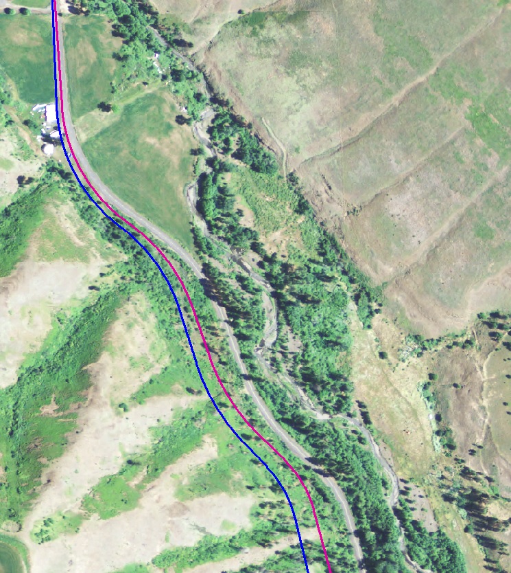
The blue line represents my first attempt and the purple line is my 2nd attempt. You can see that the purple line is closer to the actual road on the imagery.
- Mark as New
- Bookmark
- Subscribe
- Mute
- Subscribe to RSS Feed
- Permalink
- Report Inappropriate Content
Hi Alicia,
Do you have a date that the original COGO calls were generated? It almost appears that you're dealing with a magnetic declination issue considering that on the top of the pic the road appears on the highway and it departs at a fixed rate (angle.)
Trying out the NGS declination tools at NGDC Geomagnetic Calculators | ngdc.noaa.gov the current declination for Southern WA (arbitrary coordinates of 45.95N, 120.62W) is 15.34d where in 1980 it was 19.63d. That's why I was asking about the date of the calls.
Hope this helps
Tom
- Mark as New
- Bookmark
- Subscribe
- Mute
- Subscribe to RSS Feed
- Permalink
- Report Inappropriate Content
Hi Tom,
We did figured that the magnetic declination was part of the problem. After adjusting for the magnetic declination, we still had some issues at the curves. Thanks for sending the NGS declination tools, this will come in handy for other projects.
- Mark as New
- Bookmark
- Subscribe
- Mute
- Subscribe to RSS Feed
- Permalink
- Report Inappropriate Content
Alicia -
Is the survey in ground measurements with a specified basis of bearing?
CB
- Mark as New
- Bookmark
- Subscribe
- Mute
- Subscribe to RSS Feed
- Permalink
- Report Inappropriate Content
It looks like it may be more of a rotation issue than a distortion. Does the description give a tie to another point at the end? Or a basis of bearing?
If I enter a description like that, I figure the surveyor has his equipment set to a certain basis of bearing, so I feel I can rotate the traverse anchored at the beginning until it matches the actual road. Especially if there is no basis of bearing or tie point at the end provided..
Summit County, Utah
- Mark as New
- Bookmark
- Subscribe
- Mute
- Subscribe to RSS Feed
- Permalink
- Report Inappropriate Content
Unfortunately, we only have one tie for the whole project and that's at the beginning of the project.
- Mark as New
- Bookmark
- Subscribe
- Mute
- Subscribe to RSS Feed
- Permalink
- Report Inappropriate Content
Chris,
Yes, the survey has ground measurements with specified basis of bearing.
- Mark as New
- Bookmark
- Subscribe
- Mute
- Subscribe to RSS Feed
- Permalink
- Report Inappropriate Content
If I have a basis of bearing I will compare their bearing and distance with the bearing and distance between the points in my data. I then calculate the difference in angle and distance and enter them in the ground to grid correction portion of the units tab in Editing Options dialog. If my monument data isn't that great then I just rotate the road on its beginning point to match the aerial (they are describing the center of the road after all).
If I'm using the parcel fabric, I will actually enter a connection line for their basis of bearing line and join the resulting point at the other tie point.
Summit County, Utah
- Mark as New
- Bookmark
- Subscribe
- Mute
- Subscribe to RSS Feed
- Permalink
- Report Inappropriate Content
Could it also be due to inaccuracies in the photo due to local elevation change? It looks like the road runs directly next to a valley, and the elevation change might be distorting the photo somewhat. It all depends on if you have orthophotos or just regular aerials. Can you confirm that? I know this is probably closes for response, but someone else with a similar problem might be helped by this.