- Home
- :
- All Communities
- :
- Products
- :
- ArcGIS GeoEvent Server
- :
- ArcGIS GeoEvent Server Questions
- :
- TAB-separated values in tcp-text-in
- Subscribe to RSS Feed
- Mark Topic as New
- Mark Topic as Read
- Float this Topic for Current User
- Bookmark
- Subscribe
- Mute
- Printer Friendly Page
TAB-separated values in tcp-text-in
- Mark as New
- Bookmark
- Subscribe
- Mute
- Subscribe to RSS Feed
- Permalink
- Report Inappropriate Content
Hello all,
Have anyone had any luck using TAB-separated attribute values into a tcp-text-in input connector?! I have tried '\t' and '\u0008' as attribute separator in the input connector without success.
Im using a simple simulation csv-file loaded into the simulation tool like this:
TABBER "A" "B" "C" "D"
TABBER "E" "F" "G" "H"
...and a simple geoevent service like this:
tcp-text-in ---> tcp-text-out
Result is...nothing but two geoevent definitions created:
TABBER"A"B"C"D No Fields found.
TABBER"E"F"G"H No Fields found.
Any ideas?
/Erik
- Mark as New
- Bookmark
- Subscribe
- Mute
- Subscribe to RSS Feed
- Permalink
- Report Inappropriate Content
Hello Erik -
I suspect, from testing I’ve conducted, that the issue has something to do with the GeoEvent Simulator. I say this because I can drag/drop the same file I'm loading into the GeoEvent Simulator to a system folder being watched for CSV input and the Text adapter being used by both inbound connectors honors a specified Attribute Separator \u0009 (unicode value for <tab>) where as event data sent from the GeoEvent Simulator does not.
For my test, I configured a tcp-text-in input:
- To create a GeoEvent Definition based on delimited data it receives
- Specifying an Attribute Separator as either \t or \u0009
… the event definition created by the input had only one event field, suggesting the attribute separator was not recognized

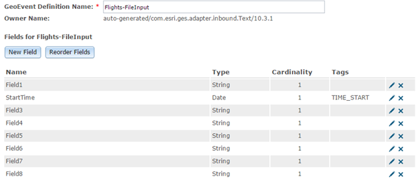
However, if I configure a file-csv-in input with similar specifications .. the event definition created has the expected fields:
Thank you for bringing this to our attention. I've submitted an issue to investigate the GeoEvent Simulator's handling of the tab delimited data. It's interesting that changing <tab> to semi-colon (;) in the input and specifying \u003B as the attribute separator works for both the GeoEvent Simulator and System File inputs. I suspect that the <tab> characters are being treated as some special form of whitespace by the Simulator.
- RJ
- Mark as New
- Bookmark
- Subscribe
- Mute
- Subscribe to RSS Feed
- Permalink
- Report Inappropriate Content
Erik -
We are making enhancements to the GeoEvent Simulator which should support the loading and simulation of data which uses <tab> characters to separate the different fields in an event. Please send an e-mail to the team alias geoevent@esri.com and request the Simulator update if you want to help test it out.
- RJ
- Mark as New
- Bookmark
- Subscribe
- Mute
- Subscribe to RSS Feed
- Permalink
- Report Inappropriate Content
Thanks RJ, I sent the request.
/Erik