- Home
- :
- All Communities
- :
- Products
- :
- 3D
- :
- 3D Questions
- :
- How to remove spikes in a raster/DEM
- Subscribe to RSS Feed
- Mark Topic as New
- Mark Topic as Read
- Float this Topic for Current User
- Bookmark
- Subscribe
- Mute
- Printer Friendly Page
- Mark as New
- Bookmark
- Subscribe
- Mute
- Subscribe to RSS Feed
- Permalink
- Report Inappropriate Content
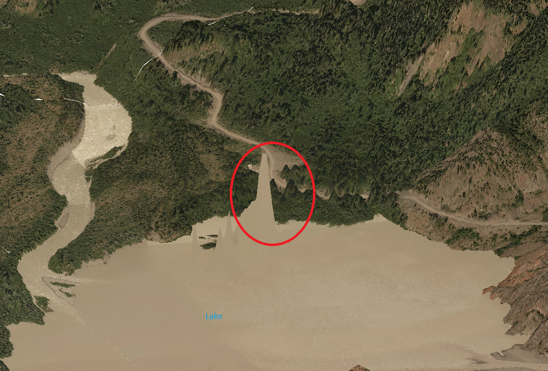
This is an oblique view of a lake and the red circle showing a spike in the DEM.
How to remove the spikes?
I use a DEM and drape the image on it in ArcScene.
I have ArcGIS Desktop Advanced + 3D Analyst
Thanks!
Solved! Go to Solution.
Accepted Solutions
- Mark as New
- Bookmark
- Subscribe
- Mute
- Subscribe to RSS Feed
- Permalink
- Report Inappropriate Content
Hello!
You can request free evaluation license of ArcGIS Spatial Analyst if necessary. However, you can also replace the values of the elevation surface by mosaicking a constant raster with existing surface.
Here's what could be done.
- If you know constant value and the area(lake boundary for example) you can create a raster with constant elevation value by converting polygon to raster. You can use original elevation raster for cell size and snapping.
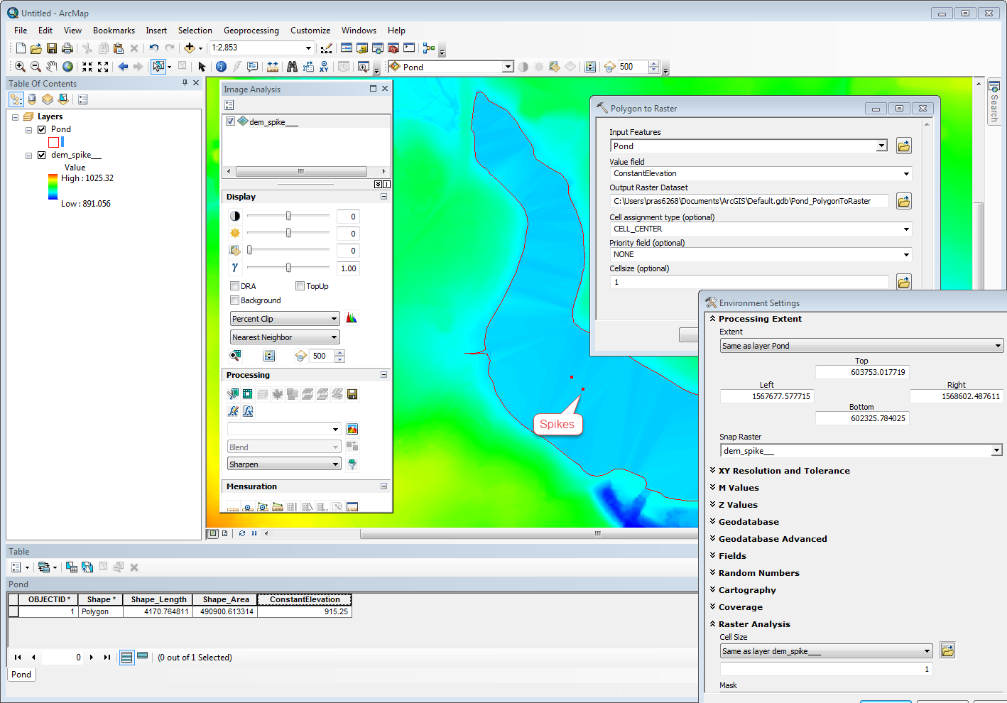
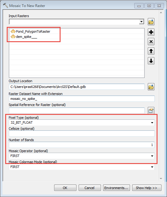
- Once you have the constant raster created, you can mosaic the two together. Make sure you select correct parameter for pixel type, number of bands, and mosaic operator.
Hope this helps.
Thank you,
Prasanta.
- Mark as New
- Bookmark
- Subscribe
- Mute
- Subscribe to RSS Feed
- Permalink
- Report Inappropriate Content
Strange...how did the DEM get the spike in the middle of the lake in the first place?
If the lake has a constant elevation (no assumptions here) you could assign the elevation to the DEM if you had the spatial analyst extension using the Con tool
- Mark as New
- Bookmark
- Subscribe
- Mute
- Subscribe to RSS Feed
- Permalink
- Report Inappropriate Content
Thanks Dan. I don't have Spatial Analyst. How can I assign or fix the spike?
- Mark as New
- Bookmark
- Subscribe
- Mute
- Subscribe to RSS Feed
- Permalink
- Report Inappropriate Content
You need the spatial analyst or its open source equivalent
- Mark as New
- Bookmark
- Subscribe
- Mute
- Subscribe to RSS Feed
- Permalink
- Report Inappropriate Content
Hello!
You can request free evaluation license of ArcGIS Spatial Analyst if necessary. However, you can also replace the values of the elevation surface by mosaicking a constant raster with existing surface.
Here's what could be done.
- If you know constant value and the area(lake boundary for example) you can create a raster with constant elevation value by converting polygon to raster. You can use original elevation raster for cell size and snapping.
- Once you have the constant raster created, you can mosaic the two together. Make sure you select correct parameter for pixel type, number of bands, and mosaic operator.
Hope this helps.
Thank you,
Prasanta.
- Mark as New
- Bookmark
- Subscribe
- Mute
- Subscribe to RSS Feed
- Permalink
- Report Inappropriate Content
Great idea, Prasanta!
- Mark as New
- Bookmark
- Subscribe
- Mute
- Subscribe to RSS Feed
- Permalink
- Report Inappropriate Content
Very good idea. It's a good alternatives when I don't have Spatial Analyst. I've already asked for the free trial once so I don't think they would give me another one 
Thanks for your time Prasanta!
- Mark as New
- Bookmark
- Subscribe
- Mute
- Subscribe to RSS Feed
- Permalink
- Report Inappropriate Content
Prasanta, I tried and it works!
Thanks a lot!