- Home
- :
- All Communities
- :
- Products
- :
- Mapping
- :
- Mapping Questions
- :
- Line Structure leading to point
- Subscribe to RSS Feed
- Mark Topic as New
- Mark Topic as Read
- Float this Topic for Current User
- Bookmark
- Subscribe
- Mute
- Printer Friendly Page
Line Structure leading to point
- Mark as New
- Bookmark
- Subscribe
- Mute
- Subscribe to RSS Feed
- Permalink
- Report Inappropriate Content
Hi to All,
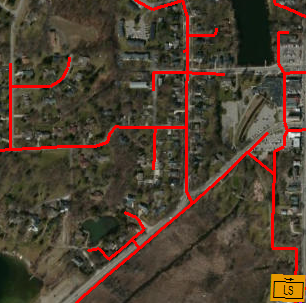
I have lines leading into different points (like shown in the image below). How would you show which lines are leading into with point? I have read about network structures. I am not sure if I need to built one and how I would do that. Maybe there is a way without.
Thanks for your help. I very appreciate your ideas. Doreen
- Mark as New
- Bookmark
- Subscribe
- Mute
- Subscribe to RSS Feed
- Permalink
- Report Inappropriate Content
Doreen,
Have a look at this thread - I believe this may help:
Alternatively, run the "Feature Vertices to Points" Tool (Located in Data Management Tools --> Features) and select "Dangle" as the point type. You can then use "Select by location" to pick up all lines that touch those dangle points.
Voila, all dead-end streets are selected.
- Mark as New
- Bookmark
- Subscribe
- Mute
- Subscribe to RSS Feed
- Permalink
- Report Inappropriate Content
Do you mean for analysis? Or do you mean for symbology? for the latter, you can chose line styles with arrow heads which show direction, You might have to alter the symbols to account for the direction of the arrow and the direction of digitizing. For analysis...you have the basics of a network dataset...what do you want to do with it?