- Home
- :
- All Communities
- :
- Developers
- :
- Python
- :
- Python Questions
- :
- arcpy.UpdateCursor setting a row value to null ins...
- Subscribe to RSS Feed
- Mark Topic as New
- Mark Topic as Read
- Float this Topic for Current User
- Bookmark
- Subscribe
- Mute
- Printer Friendly Page
arcpy.UpdateCursor setting a row value to null instead of 0
- Mark as New
- Bookmark
- Subscribe
- Mute
- Subscribe to RSS Feed
- Permalink
- Report Inappropriate Content
Hi,
I'm having issues setting a row value to 0 when joining a csv to a shapefile. When the shapefile value is not in the csv, the row is getting set to 0 instead of null. This is a huge problem as i'm showing 0 change instead of no data. I tried row.setValue(field, None) and row.setNull(field) and both produce the same result. In the .dbf file of the shapefile, there is no value but in the UI attribute table a 0 is shown. Any advice on how to fix this would be very appreciated.
Thanks!
Shane
arcpy.AddField_management(shpfile, "TEST", "DOUBLE", field_is_nullable = 'NULLABLE')
newcols = ["TEST"]
with open(csvfile, 'rb') as csvfile:
lib = dict()
csvfile = csv.reader(csvfile, delimiter = ",")
csvfile.next() #skip the headers
for line in csvfile:
lib[line[csvjoinindex]] = lib.get(line[csvjoinindex],line[csvstartfield:])
rows = arcpy.UpdateCursor(shpfile)
for row in rows:
shpjoinval = str(row.getValue(shapefilejoincol))
try:
vals = lib.get(shpjoinval)
for ind, field in enumerate(newcols):
row.setValue(str(field),vals[ind])
rows.updateRow(row)
except:
for ind, field in enumerate(newcols):
row.setNull(field)
rows.updateRow(row)
- Mark as New
- Bookmark
- Subscribe
- Mute
- Subscribe to RSS Feed
- Permalink
- Report Inappropriate Content
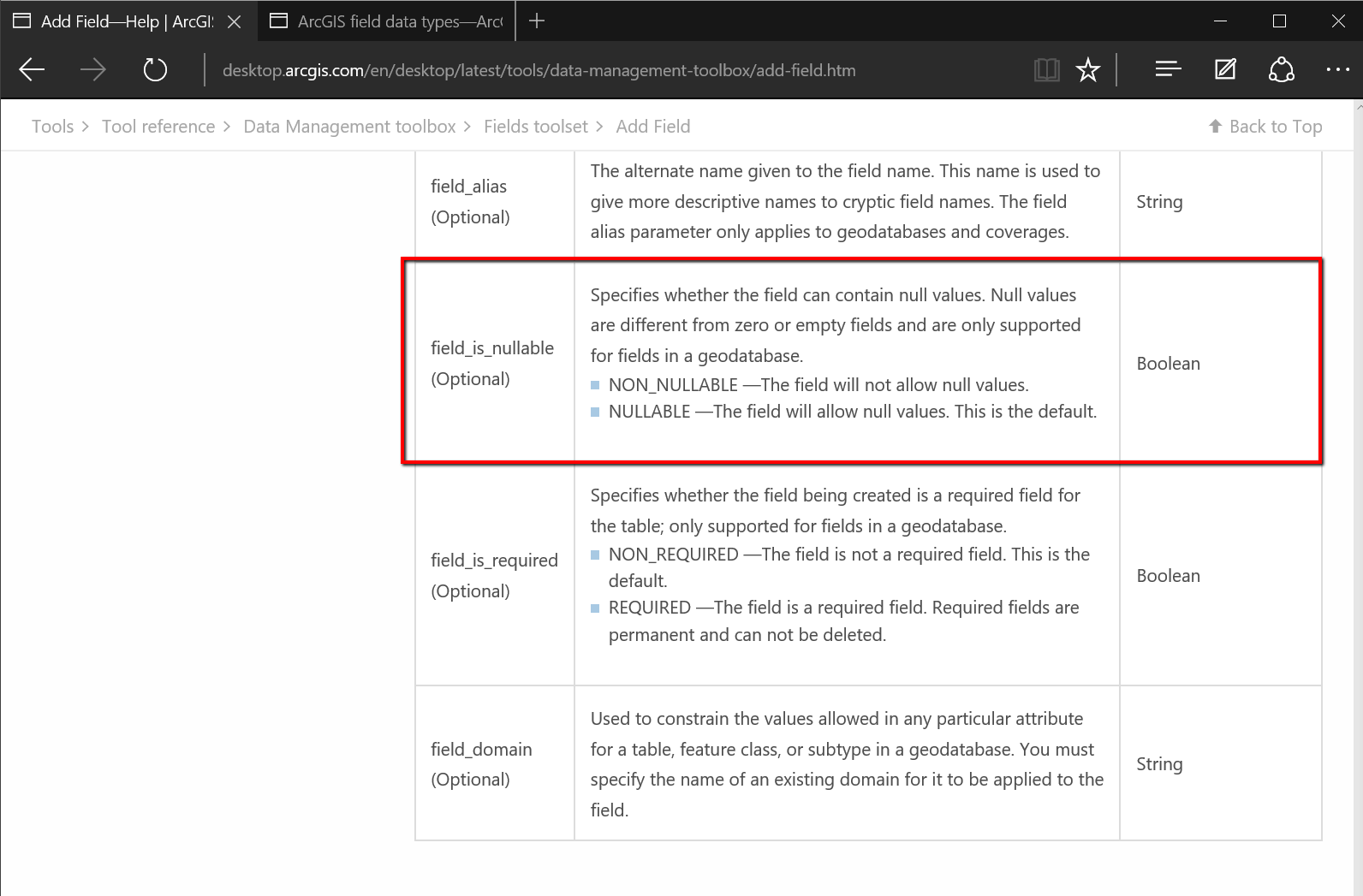
You'd need to use a geodatabase feature class instead of a shapefile to accomplish this. Shapefiles do not support NULL values. This is documented on the following page:
Add Field (Data Management)
http://desktop.arcgis.com/en/desktop/latest/tools/data-management-toolbox/add-field.htm
As shown in the screenshot below, Null values are only supported for fields in a geodatabase.
- Mark as New
- Bookmark
- Subscribe
- Mute
- Subscribe to RSS Feed
- Permalink
- Report Inappropriate Content
specifics to shapefiles regarding nulls or lack thereof
| Data type containing null value | Null value substitution |
|---|---|
Number—When tool requires that a NULL, infinity, or NaN (Not a Number) be output | -1.7976931348623158e+308 (IEEE standard for the maximum negative value) |
Number (all other geoprocessing tools) | 0 |
Text | " " (blank—no space) |
Date | Stored as zero, but displays <null> |
from here Geoprocessing considerations for shapefile output—Help | ArcGIS for Desktop