- Home
- :
- All Communities
- :
- Industries
- :
- Water Utilities
- :
- Water Utilities Questions
- :
- Water Utility Reporting Toolbar - Profiling Tool
- Subscribe to RSS Feed
- Mark Topic as New
- Mark Topic as Read
- Float this Topic for Current User
- Bookmark
- Subscribe
- Mute
- Printer Friendly Page
Water Utility Reporting Toolbar - Profiling Tool
- Mark as New
- Bookmark
- Subscribe
- Mute
- Subscribe to RSS Feed
- Permalink
- Report Inappropriate Content
I'm trying to use the Profiling Tool on the Water Utility Reporting Toolbar (although mine is called the Infrastructure Reporting Toolbar) for a section of my stormwater utility network. Since I am not currently using ESRI's Local Government Model I have configured the tool to work with my network.
The tool runs successfully - albeit with a few problems - on a section of pipe where I have no elevations included in my attribute data. I get a profile like this:
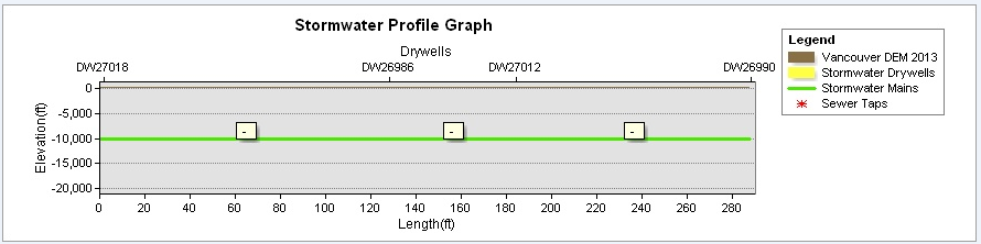
The main is shown at -10,000 ft. (obviously a problem) and my drywells are not visible, but at least the tool generates a result.
After I add elevation attribute data to my network (drywell rim and bottom elevations, main upstream/downstream inverts) the tool gives me the following error: Error in the ProfileGetRelatedSewerElevData Specified cast is not valid.
Can anyone help me determine what I'm doing wrong with my configuration? What is the "specified cast"? I need to show accurate elevations in my y-axis and I need my drywells to be visible. I have attached my configuration file if that helps. I am using ArcGIS 10.2.2.3552 for Desktop with an Advanced license.
Many thanks in advance!
- Mark as New
- Bookmark
- Subscribe
- Mute
- Subscribe to RSS Feed
- Permalink
- Report Inappropriate Content
See if the Utilities and Communications sub-space helps.
- Mark as New
- Bookmark
- Subscribe
- Mute
- Subscribe to RSS Feed
- Permalink
- Report Inappropriate Content
Thanks, Mitch. I thought I would get more hits in the Local Government forum but it looks like Utilities is where I need to be. Hard to know where to point these questions sometimes!
- Mark as New
- Bookmark
- Subscribe
- Mute
- Subscribe to RSS Feed
- Permalink
- Report Inappropriate Content
Yeah, it is! Hopefully, someone here and there can help. Sorry I can't! 
- Mark as New
- Bookmark
- Subscribe
- Mute
- Subscribe to RSS Feed
- Permalink
- Report Inappropriate Content
Config looks correct. Can you try the latest version of the the tools? We renamed them a while ago and there could already be a fix for this issue if it was a bug in them. If the most recent tools do not work, could you send a small subset of the data to? mmiller@esri.com
- Mark as New
- Bookmark
- Subscribe
- Mute
- Subscribe to RSS Feed
- Permalink
- Report Inappropriate Content
Thanks for your response, Michael.
I downloaded the latest version of the tools and ran the AddIn file. The tools were obviously updated but the Loaded.config file did not change. Now when I try to select my first point I get a window that says "A location was not found."
I've attached a small selection of the stormwater drywells and mains I'm working with, as well as a section of our DEM.
- Mark as New
- Bookmark
- Subscribe
- Mute
- Subscribe to RSS Feed
- Permalink
- Report Inappropriate Content
The config file location probably changed since the version you were using. If you have the attribute assistant installed, there is a tool on its toolbar to show you the config file. Make sure to update it to match your layer names.
- Mark as New
- Bookmark
- Subscribe
- Mute
- Subscribe to RSS Feed
- Permalink
- Report Inappropriate Content
I found the new location of the Loaded.config file and updated it with my layer names. However, I'm still getting the same results as I outlined in the first post above.
Any idea what is meant by "Error in the ProfileGetRelatedSewerElevData Specified cast is not valid"?
- Mark as New
- Bookmark
- Subscribe
- Mute
- Subscribe to RSS Feed
- Permalink
- Report Inappropriate Content
I am able to repo the error. The issue is trying to convert the elevations from a text field in the drywells to a double. If you create a new field, called RimElev2 as type double, and calculate its value from the RimElev field of type text, it should resolve the issue. I will add logic to fix this and support text fields in a future release.
- Mark as New
- Bookmark
- Subscribe
- Mute
- Subscribe to RSS Feed
- Permalink
- Report Inappropriate Content
Makes sense. I'll have to get my database administrator on that one. I'm not sure why we wrote that field as a string in the first place.
Thanks for all your help, Michael!