- Home
- :
- All Communities
- :
- Industries
- :
- Natural Resources
- :
- Natural Resources Questions
- :
- Monthly average snow depth
- Subscribe to RSS Feed
- Mark Topic as New
- Mark Topic as Read
- Float this Topic for Current User
- Bookmark
- Subscribe
- Mute
- Printer Friendly Page
- Mark as New
- Bookmark
- Subscribe
- Mute
- Subscribe to RSS Feed
- Permalink
- Report Inappropriate Content
I am trying to import the monthly average snow depth data for 1998-2014 from Canadian Meteorological Centre (http://nsidc.org/data/NSIDC-0447/versions/1) into ArcGIS (ArcMap 10.3). I downloaded the text files (cmc_analysis_mly_avg_1998.txt etc.) and wrote this header (as it does not have one):
ncols 706
nrows 706
xllcorner -125.000000
yllcorner 0.1665461
cellsize 10
nodata_value -9999
I used Ascii to raster in Arc toolbox, the transformation seemed successful, and an image appeared. However the image does not look like the northern hemisphere. I also tried to define projection (tried both north pole stereographic projection and WGS1984 arctic polar stereographic projection) using Define projection in the toolbox, but in both cases the image “disappeared” (cannot not see it even when zooming to layer or raster resolution). I guess the information in my header is wrong. I suspect that at least llcorner might be a problem - I used the coordinates from row 1, column 1 in cmc_analysis_ps_lat_long.txt file.
Has anyone done this and have a correct header, or can someone help me understand how to write the header? It seems as I have not understood how to use the information in the CMC snow depth documentation correctly.
Solved! Go to Solution.
Accepted Solutions
- Mark as New
- Bookmark
- Subscribe
- Mute
- Subscribe to RSS Feed
- Permalink
- Report Inappropriate Content
Here's a start that gets me close. I'm not 100% sure that it's even possible to fit this dataset exactly, in all parts of the raster at the same time.
The pertinent information can be found here (I'll note that they indicate that you can use the lat/long file [txt and xlsx attached], but you'd have to do a fair bit of manipulation to tie the points to the ASCII grid values):
Grid Specification:
North Polar Stereographic
ni (# rows) = 706, nj (# cols) = 706, bottom left grid point = (1,1)
Grid rotation -10°
Pole position = (353, 353)
Grid resolution at 60°N = 23812.5 m
So, your header should look like:
NCOLS 706
NROWS 706
XLLCENTER 1
YLLCENTER 1
CELLSIZE 23812.5
NODATA_VALUE 0 [or another value like 999 if you want to include values of 0]
You also need to define a custom coordinate reference system to make it line up with the world, once you've converted ASCII To Raster:
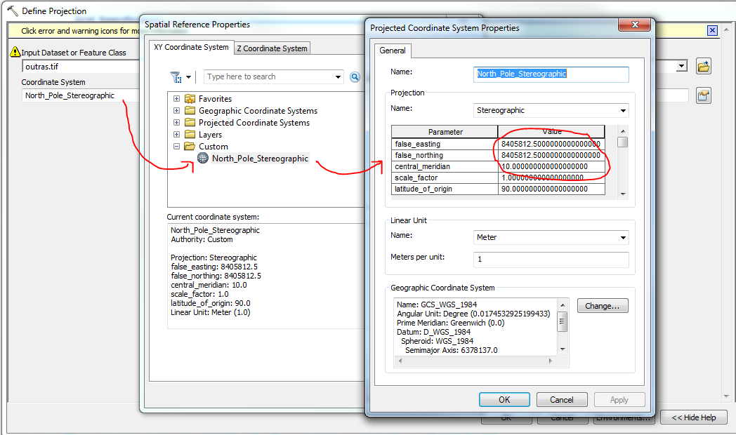
false_easting and false_northing = 8405812.5 = cellsize * pole position
central_meridian = 10
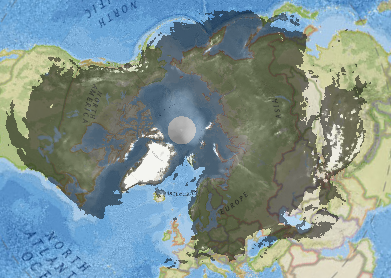
The final result is:
- Mark as New
- Bookmark
- Subscribe
- Mute
- Subscribe to RSS Feed
- Permalink
- Report Inappropriate Content
check the documentation, i suspect they want coordinates and these
xllcorner -125.000000
yllcorner 0.1665461
cellsize 10
suggest a longitude of -125 degrees with a latitude of 0.1665461 with a cellsize of 10 degrees (which seems tad off). Also, I think the lower left coordinate is the origin (I think) and it would be in a geographic projection probably. Sooo, can you provide the documentation notes, so people don't have to create an account to download the data?
PS
Re: Monthly average snow depth files this has risen before...I wonder why they provide fortran code
- Mark as New
- Bookmark
- Subscribe
- Mute
- Subscribe to RSS Feed
- Permalink
- Report Inappropriate Content
Here's a start that gets me close. I'm not 100% sure that it's even possible to fit this dataset exactly, in all parts of the raster at the same time.
The pertinent information can be found here (I'll note that they indicate that you can use the lat/long file [txt and xlsx attached], but you'd have to do a fair bit of manipulation to tie the points to the ASCII grid values):
Grid Specification:
North Polar Stereographic
ni (# rows) = 706, nj (# cols) = 706, bottom left grid point = (1,1)
Grid rotation -10°
Pole position = (353, 353)
Grid resolution at 60°N = 23812.5 m
So, your header should look like:
NCOLS 706
NROWS 706
XLLCENTER 1
YLLCENTER 1
CELLSIZE 23812.5
NODATA_VALUE 0 [or another value like 999 if you want to include values of 0]
You also need to define a custom coordinate reference system to make it line up with the world, once you've converted ASCII To Raster:
false_easting and false_northing = 8405812.5 = cellsize * pole position
central_meridian = 10
The final result is:
- Mark as New
- Bookmark
- Subscribe
- Mute
- Subscribe to RSS Feed
- Permalink
- Report Inappropriate Content
Thanks all of you for the answers. Darren, I appreciated your clear explanation - it worked just fine.
- Mark as New
- Bookmark
- Subscribe
- Mute
- Subscribe to RSS Feed
- Permalink
- Report Inappropriate Content
Hi
I am new to work on snow depth data. I read about this snow depth data and i run given above header file.
but it doesn't give snow depth for my study area. I want to calculate snow depth data for Hindu Kush Himalayan (India, Pakistan region). I think for specific area we have to change header file But I am not getting how to change it? according to my study are and projection for Hindu Kush Himalayan. Kindly give some more details to get snow depth data for mentioned above study area.
Waiting for kind response.