- Home
- :
- All Communities
- :
- Products
- :
- Data Management
- :
- Data Management Questions
- :
- Import polygons with auto clip?
- Subscribe to RSS Feed
- Mark Topic as New
- Mark Topic as Read
- Float this Topic for Current User
- Bookmark
- Subscribe
- Mute
- Printer Friendly Page
Import polygons with auto clip?
- Mark as New
- Bookmark
- Subscribe
- Mute
- Subscribe to RSS Feed
- Permalink
- Report Inappropriate Content
This seems so basic, but I'm not finding a solution.
I have; (1) a polygon shapefile containing multiple polygons, and (2) a versioned enterprise geodatabase (SQL server) polygon layer. The shapefile and geodatabase contain the same file structure.
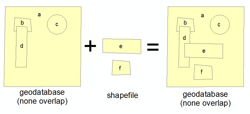
I would like to import the shapefile polygons into the geodatabase AND remove (clip away) any overlap from the geodatabase layer.
The data layers consist of zoning polygons. The geodatabase layer is the existing county zoning layer, covering the entire county. The shapefile contains new zoning areas to import into the geodatabase layer. The new areas must remove any overlapping area from the geodatabase layer.
I can do this manually in an edit session, but only one polygon at a time. (a) copy area from shapefile, (b) paste into geodatabase layer, and (c) select "clip" (from the editor menu) clipping away overlap from geodatabase. When trying the same process with multiple polygon's, the clip option was not available.
Thanks in advance.
BTW: ArcGIS 10.3.1 Standard
- Mark as New
- Bookmark
- Subscribe
- Mute
- Subscribe to RSS Feed
- Permalink
- Report Inappropriate Content
Have you looked at Clip—Help | ArcGIS for Desktop in toolbox?
- Mark as New
- Bookmark
- Subscribe
- Mute
- Subscribe to RSS Feed
- Permalink
- Report Inappropriate Content
Thanks Wes,
Yes, but this creates a new feature class. It does not (seem to) work with an existing layer as in my case.
- Mark as New
- Bookmark
- Subscribe
- Mute
- Subscribe to RSS Feed
- Permalink
- Report Inappropriate Content
You could truncate and append the new features in the old feature class.
Truncate Table—Help | ArcGIS for Desktop
Append—Help | ArcGIS for Desktop
Edit: You might want to make a copy of your data before hand.
- Mark as New
- Bookmark
- Subscribe
- Mute
- Subscribe to RSS Feed
- Permalink
- Report Inappropriate Content
Neither of these are appropriate either. The truncate does not work with versioned data and does not consider the "shape" of an area. Append does not "clip" out the area, but creates new areas from the overlaps.
Here's a visual example of what I'm trying to do:
- Mark as New
- Bookmark
- Subscribe
- Mute
- Subscribe to RSS Feed
- Permalink
- Report Inappropriate Content
Use Erase—Help | ArcGIS for Desktop then append the polys(shapefile)
- Mark as New
- Bookmark
- Subscribe
- Mute
- Subscribe to RSS Feed
- Permalink
- Report Inappropriate Content
I run into this also with my work for the City and have not come up with a great way to do this (but am still looking). Here's two workflows that may help:
- Given the geoprocessing limitations that come with Versions, I usually opt to dump the data out to a File Geodatabase, do the necessary geoprocessing there, delete the affected polygons in the Version, then Append back in the new polygons to the Version. Tedious, but it works.
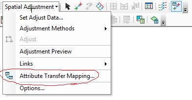
- Another workflow that can be effective if there are only a few features to update is to use the Attribute Transfer tool (Spatial Adjustment Toolbar) to update the geometry and/or the attributes while still in the Version by "transferring" the information from a source feature class. If you do go this route, 2 tips: make sure both the source and target layers are selectable, and after making the transfer, realize you may have to Refresh the view to see the geometry changes (it often lags, making it seem like nothing happened).
EDIT - added more images.
Chris Donohue, GISP
- Mark as New
- Bookmark
- Subscribe
- Mute
- Subscribe to RSS Feed
- Permalink
- Report Inappropriate Content
Chris,
Have not tried the first suggested process because it seems to work with non-overlapping areas. Our entire county is covered by zoning polygons.
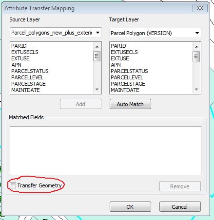
The second process I'm very familiar with, however I've not used the "Transfer Geometry" option. This did not work either - or I was doing it wrong. I'll explain by using my example image, in another message: When zones "e" & "f" are transferred to zone "a", the entire shape of "a" is modified to match the shape and size of "e" or "f" instead of "clipping" away their shape from "a"
- Mark as New
- Bookmark
- Subscribe
- Mute
- Subscribe to RSS Feed
- Permalink
- Report Inappropriate Content
One can follow these steps (You can optimize the workflow by creating a model).
1. Exporting the shapefile to geodatabase (Let me call it "Feat2")
Feature Class To Feature Class—Help | ArcGIS for Desktop
2. Remove the overlapping area of Feat1 using Feat2 using Erase (Analysis) tool.
Erase—Help | ArcGIS for Desktop
3. Append Feat2 to Feat1.
Append—Help | ArcGIS for Desktop
Think Location
- Mark as New
- Bookmark
- Subscribe
- Mute
- Subscribe to RSS Feed
- Permalink
- Report Inappropriate Content
Jayanta,
I've looked at "erase", but it's only available with an "ArcGIS for Desktop Advanced" license. Plus, erase outputs to a new feature class, that is, it does not erase features from an existing layer.