- Home
- :
- All Communities
- :
- Industries
- :
- State & Local Government
- :
- State & Local Government Questions
- :
- NAD 83(2011) to NAD 83 - Which transformation shou...
- Subscribe to RSS Feed
- Mark Topic as New
- Mark Topic as Read
- Float this Topic for Current User
- Bookmark
- Subscribe
- Mute
- Printer Friendly Page
NAD 83(2011) to NAD 83 - Which transformation should I use?
- Mark as New
- Bookmark
- Subscribe
- Mute
- Subscribe to RSS Feed
- Permalink
- Report Inappropriate Content
I have data in 'NAD_1983_2011_StatePlane_North_Carolina_FIPS_3200_Ft_US' (wkid 6543) that needs to be loaded into a project that's in 'NAD_1983_StatePlane_North_Carolina_FIPS_3200_Feet' (wkid 2264). Which transformation do I need to use for this?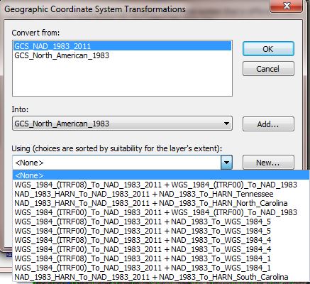
Jack Drost
Henderson County IT/GIS
Hendersonville, North Carolina
- Mark as New
- Bookmark
- Subscribe
- Mute
- Subscribe to RSS Feed
- Permalink
- Report Inappropriate Content
Jack see if this helps
Choosing an appropriate transformation—Help | ArcGIS for Desktop
- Mark as New
- Bookmark
- Subscribe
- Mute
- Subscribe to RSS Feed
- Permalink
- Report Inappropriate Content
I bet Melita Kennedy would probably know.
Chris Donohue, GISP
- Mark as New
- Bookmark
- Subscribe
- Mute
- Subscribe to RSS Feed
- Permalink
- Report Inappropriate Content
Hi Jack,
Maybe nothing, depending on the accuracy of your data. Is the other data (using NAD 1983 like the data frame/map) really on NAD 1983 (1986) or could it be a mix of HARN, NSRS2007, 2011, CORS96, etc.?
In 10.4.0, we added support for GEOCON v1 grids/transformations, which convert between HARN and NSRS2007 and between NSRS2007 and 2011. That also means a lot of concatenation of transformations you have NAD27 or NAD83 in the mix. Right now, ArcMap only supports concatenating 2 transformations, you could convert from HARN to 2011, but not the original NAD83 to 2011.
Prior to 10.4.0, ArcGIS will piece together two transformations to convert from NAD83 to 2011, usually via ITRF00 or ITRF08. Most of those transformations are already approximations (where I used the same parameters with different GCS) that I put in, to remove most of the offsets between the two systems. For instance, once suggestion in ArcMap is
WGS_1984_(ITRF00)_To_NAD_1983 + WGS_1984_(ITRF00)_To_NAD_1983_2011
Those are both the same transformation, just with different NAD 1983 realizations. It was originally designed for approximately CORS96/HARN data, but if you've a NAD 1983-defined data that's really mixed...
- Mark as New
- Bookmark
- Subscribe
- Mute
- Subscribe to RSS Feed
- Permalink
- Report Inappropriate Content
Most of our data is in the original NAD 1983 (I guess that is the 1986 variation), since it was originally re-projected from NAD 27 years ago. Is there a way I can find out what the actual offset distance between NAD 83 vs. 2011 vs. NSRS2007 is for our area? If it's a matter of millimeters or a few centimeters then maybe we can live without doing a transformation....?
Thanks for your help with this.
- Mark as New
- Bookmark
- Subscribe
- Mute
- Subscribe to RSS Feed
- Permalink
- Report Inappropriate Content
Hi Jack,
The first step is to get some test points into "HARN"/HPGN. You could use NGS's NADCON program. I think you have to download it, as the online calculator doesn't seem to support NAD83 to HARN. You could also extract a few points and reproject them using the Project Tool and just set the appropriate HARN grid for the area.
For the HARN to NSRS2007 to 2011 transformations, you'll have to use NGS's GEOCON v2.0 program.
It's...a bit complicated. So first follow the "show all realizations" link on the left and look up your state. Then look through the user guide to find out the what's allowed in the "free format" (or use Blue Book if you know it). For NC, it looks like you'll do an HARN to FBN, then FBN to 2011.
I think the biggest change will be from NAD83 to HARN, and the others will be smaller.
- Mark as New
- Bookmark
- Subscribe
- Mute
- Subscribe to RSS Feed
- Permalink
- Report Inappropriate Content
You can put a bunch of different projections of the same data into a map, then remove the data frame coordinate system to get a visual comparison (I had to restart ArcMap for this to work) of the differences between the different NAD83 realizations, (or any other projections) as detailed here.
I did this to convince myself the NAD83 1986 vs. 2011 realizations are of no more than 0.01cm difference in my area (also in the tectonically stable SE US). I noticed ArcMap sometimes reassigned the data frame coordinate system to the first projection it found in the layers so I also removed the .prj files so there was no way it could attempt to on-the-fly project.
- Mark as New
- Bookmark
- Subscribe
- Mute
- Subscribe to RSS Feed
- Permalink
- Report Inappropriate Content
I was advised by the State of NC that the differences in this data are very slight for our area, to the point that it wouldn't be noticed in the GIS software. Thanks for all the assistance nonetheless!