- Home
- :
- All Communities
- :
- Products
- :
- 3D
- :
- 3D Questions
- :
- Getting 3D length for a line along a surface
- Subscribe to RSS Feed
- Mark Topic as New
- Mark Topic as Read
- Float this Topic for Current User
- Bookmark
- Subscribe
- Mute
- Printer Friendly Page
- Mark as New
- Bookmark
- Subscribe
- Mute
- Subscribe to RSS Feed
- Permalink
- Report Inappropriate Content
I need to get an "actual" length of a path along a 3D surface. I've tried ADD SURFACE INFORMATION, ADD Z INFORMATION and a couple of tools from Spatial analyst (Path distance, thinking that might work) but nothing does. First used a DEM for the surface and realized the "data" was all 10m. apart, so probably messed that up, converted it to a TIN but keep coming up with the same results. Z distance is the same as using the "distance tool" or drawing a graphic line on the map. It's all 43 miles. !? Any ideas?
thanks!
Pete
Solved! Go to Solution.
Accepted Solutions
- Mark as New
- Bookmark
- Subscribe
- Mute
- Subscribe to RSS Feed
- Permalink
- Report Inappropriate Content
Thank you Prasanta!
I did find the “Interpolate Shape” tool, (and added the 3D length field) it DID give me a different number for 3D length, by 7 miles. That does not seem right (but ?) the 264 mile Reservation boundary mostly follows watershed divides in the Rockies with an overall 2000m (~3000 ft. to 9000ft.)elevation fluctuation. I’ve enclosed the profile graph it produced, which definitely appears to have worked (I’ve labeled physical features that appear to make sense – it runs from the NE corner, south to Evaro Hill, west to the Flathead River, north, then east back towards Flathead Lake and the NE point of beginning).
Thanks to all who have answered or responded, will run with this for now.
- Mark as New
- Bookmark
- Subscribe
- Mute
- Subscribe to RSS Feed
- Permalink
- Report Inappropriate Content
If your units are in meters what results did you get from the add surface information analysis?
Add Surface Information—Help | ArcGIS for Desktop
There are a number of options there but you don't specify what you are using to get the surface information?
- Mark as New
- Bookmark
- Subscribe
- Mute
- Subscribe to RSS Feed
- Permalink
- Report Inappropriate Content
Hi thanks,
I think I mentioned I used a DEM at first (Raster dataset?), then thought it might have to be a TIN, so I converted that DEM into a TIN. The units are in meters, but when it added the Z-length field it was identical to the ShapeLength number. A graphic line on the map is the same distance.
Any other thoughts?
Thanks!
- Mark as New
- Bookmark
- Subscribe
- Mute
- Subscribe to RSS Feed
- Permalink
- Report Inappropriate Content
Hello Pete!
Are you using the Add Surface Information tool as Dan suggested? It should give you the surface length from your DEM. On my screen capture below, SLength attribute is the 3D length (which is different from Shape_Length) after running Add Surface Information tool. 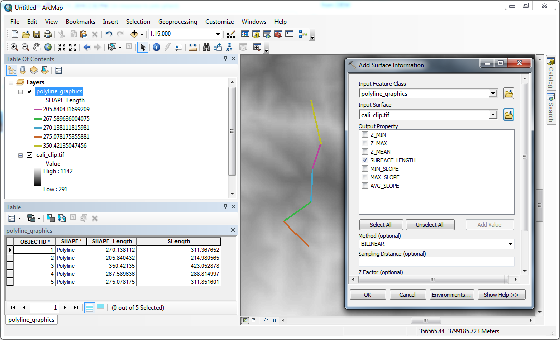
Thanks,
Prasanta.
- Mark as New
- Bookmark
- Subscribe
- Mute
- Subscribe to RSS Feed
- Permalink
- Report Inappropriate Content
If for any reason Add Surface Information is NOT working for you, you should also be able to calculate the same using following steps:
1. Interpolate Shape > Input surface: DEM; Input features: Polyline; and rest as default options.
2. Add a field (double) then Calculate Geometry to calculate 3D Length Property.
For me, this gave same/similar results as adding surface length.

Hope this help!
Thanks,
Prasanta.
- Mark as New
- Bookmark
- Subscribe
- Mute
- Subscribe to RSS Feed
- Permalink
- Report Inappropriate Content
Thank you Prasanta!
I did find the “Interpolate Shape” tool, (and added the 3D length field) it DID give me a different number for 3D length, by 7 miles. That does not seem right (but ?) the 264 mile Reservation boundary mostly follows watershed divides in the Rockies with an overall 2000m (~3000 ft. to 9000ft.)elevation fluctuation. I’ve enclosed the profile graph it produced, which definitely appears to have worked (I’ve labeled physical features that appear to make sense – it runs from the NE corner, south to Evaro Hill, west to the Flathead River, north, then east back towards Flathead Lake and the NE point of beginning).
Thanks to all who have answered or responded, will run with this for now.
- Mark as New
- Bookmark
- Subscribe
- Mute
- Subscribe to RSS Feed
- Permalink
- Report Inappropriate Content
See this thread Construct Points on polyline at 3d distance and the vector solution provided by Xander Bakker