- Home
- :
- All Communities
- :
- User Groups
- :
- Coordinate Reference Systems
- :
- Questions
- :
- Arc Desktop has trouble correctly projecting from ...
- Subscribe to RSS Feed
- Mark Topic as New
- Mark Topic as Read
- Float this Topic for Current User
- Bookmark
- Subscribe
- Mute
- Printer Friendly Page
Arc Desktop has trouble correctly projecting from ETRS to UTM?
- Mark as New
- Bookmark
- Subscribe
- Mute
- Subscribe to RSS Feed
- Permalink
- Report Inappropriate Content
Task is to project a DEM from ETRS_1989_UTM_Zone_30N to WGS 84 / UTM zone 29N. Easy enough right? Process succeeds, but inaccurately.
I have recently read on this ESRI Geonet post by Melita Kennedy that ArcDesktop has issues with this projection because of the following:
Some LAEA data uses a sphere rather than an ellipsoid/spheroid which if the metadata isn't correct can cause problems when the data is reprojected.
I tried to redefine the projection from ETRS to LAEA like the link above states. No luck.
Solved! Go to Solution.
Accepted Solutions
- Mark as New
- Bookmark
- Subscribe
- Mute
- Subscribe to RSS Feed
- Permalink
- Report Inappropriate Content
You could try changing the coordinate system, ED 1950 UTM Zone 30N, to the DEM, and set a transformation, ED_1950_To_WGS_1984_28 or ED_1950_To_WGS_1984_41_NTv2_Spain_v2 (accuracy is better with the second one). This assumes the DEM's coordinate system was defined incorrectly. ETRS 1989 and WGS 1984 should differ by more than a meter or so.
Melita
- Mark as New
- Bookmark
- Subscribe
- Mute
- Subscribe to RSS Feed
- Permalink
- Report Inappropriate Content
you said 'redefine', did you mean 'project' ??
- Mark as New
- Bookmark
- Subscribe
- Mute
- Subscribe to RSS Feed
- Permalink
- Report Inappropriate Content
Hi Shelby,
Also posted (with picture) at GIS stackexchange.
The Geonet post you mentioned was a specific case where there was a question about the "true" coordinate system of the DEM. Is your DEM from the same source?
If you add the original DEM (with a definition of ETRS_1989_UTM_Zone_30N) does it look correctly positioned if you compare it with a base map or other data in "Web Mercator" or geographic coordinates (ETRS 1989 / WGS 1984)?
What's the offset of the horizontal line in the polygon to the ridge?
What's the coordinate system of the polygon. Specifically, what geographic coordinate system is it using? The offset could be a geographic coordinate system/datum offset.
Melita
- Mark as New
- Bookmark
- Subscribe
- Mute
- Subscribe to RSS Feed
- Permalink
- Report Inappropriate Content
Hi Melita,
thanks for your very quick response, I appreciate your efforts.
To answer your questions:
The Geonet post you mentioned was a specific case where there was a question about the "true" coordinate system of the DEM. Is your DEM from the same source?
No, the DEM was delivered to me in the IMAGINE format, with the ETRS_1989_UTM_Zone_30N Spatial reference. Since the original dataset was for the entire province of Andalucia in Spain, it makes sense that the coordinate system above was used.
If you add the original DEM (with a definition of ETRS_1989_UTM_Zone_30N) does it look correctly positioned if you compare it with a base map or other data in "Web Mercator" or geographic coordinates (ETRS 1989 / WGS 1984)?
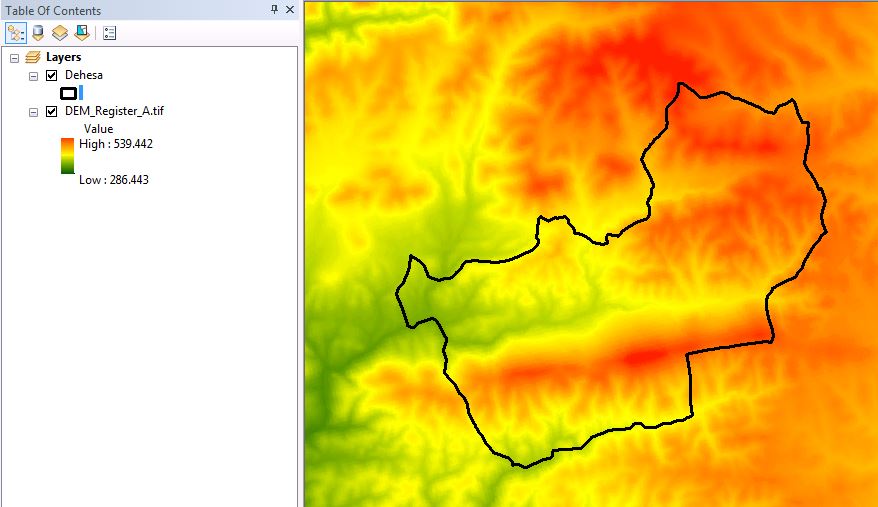
The Polygon in my previous post perfectly lines up with the ridge of ESRI's basemaps (WGS Web Mercator). The DEM exibits the same exact spatial characteristics as in the picture, slightly north of where it should be.
What's the offset of the horizontal line in the polygon to the ridge?
Im not quite sure what you mean by this. The polygon lines up nicely with the ridge of the basemaps. It doesnt line up well with the ridge of the DEM. The DEM seemed to be about 500 meters offset North-Northeast. I think it only needs to be moved, not warped to fit.
What's the coordinate system of the polygon. Specifically, what geographic coordinate system is it using?
The coordinate system of the polygon is WGS_1984_UTM_zone_29N which lines up perfectly with the basemap.
I've attached results from my own attempt to use the spatial adjustment tool (register raster) to fix it. It's better than before. I'm doing an analysis with half meter resolution ortho imagery, so I really need this to be spot on.
I can privately share the DEM (5.5 GB), and the polygon with you if you need it.
- Mark as New
- Bookmark
- Subscribe
- Mute
- Subscribe to RSS Feed
- Permalink
- Report Inappropriate Content
You could try changing the coordinate system, ED 1950 UTM Zone 30N, to the DEM, and set a transformation, ED_1950_To_WGS_1984_28 or ED_1950_To_WGS_1984_41_NTv2_Spain_v2 (accuracy is better with the second one). This assumes the DEM's coordinate system was defined incorrectly. ETRS 1989 and WGS 1984 should differ by more than a meter or so.
Melita
- Mark as New
- Bookmark
- Subscribe
- Mute
- Subscribe to RSS Feed
- Permalink
- Report Inappropriate Content
Melita,
your suggested method in your last post worked absolutely perfectly, you really know your stuff!  I cannot thank you enough, this was very important to the success of my project.
I have one final question for you. Could you explain why you think I had this projection issue? Is the DEM incorrectly defined in the first place? I just want to know so I understand it for next time this happens 
1000 thank-yous,
Shelby
- Mark as New
- Bookmark
- Subscribe
- Mute
- Subscribe to RSS Feed
- Permalink
- Report Inappropriate Content
Well, either the DEM's coordinate system was wrong to begin with--and it could have been simple as someone looking for a definition starting with "E" and not fully reading the name. OR, all your other data is wrong! But since you said that overlaying it with base maps worked fine, that pointed to the DEM having a problem.
When data doesn't line up:
Data off by less than a meter or so: could be scale / accuracy differs between the two layers AKA aerial photo versus 1:100000 or smaller data
Data off by a few meters to a few hundred meters: likely a geographic/datum transformation problem
Data off by lots/can't see both layers in ArcMap at the same time: one has missing or incorrect coordinate system
1. Is there a geographic/datum transformation set? Possibly try a different one if one is set but data is off by a meter or so.
2. What happens when I overlay the data with another "trusted" source (like a base map)?
3. Using (2), do the lat/lon coordinates look correct for the "bad" layer (for data in a projected coordinate system)? This check can help identify an incorrect coordinate system.