- Home
- :
- All Communities
- :
- User Groups
- :
- Coordinate Reference Systems
- :
- Questions
- :
- Customising the data frame spatial reference
- Subscribe to RSS Feed
- Mark Topic as New
- Mark Topic as Read
- Float this Topic for Current User
- Bookmark
- Subscribe
- Mute
- Printer Friendly Page
Customising the data frame spatial reference
- Mark as New
- Bookmark
- Subscribe
- Mute
- Subscribe to RSS Feed
- Permalink
- Report Inappropriate Content
ArcDesktop 10.2.2. Coordinate system: WGS84.
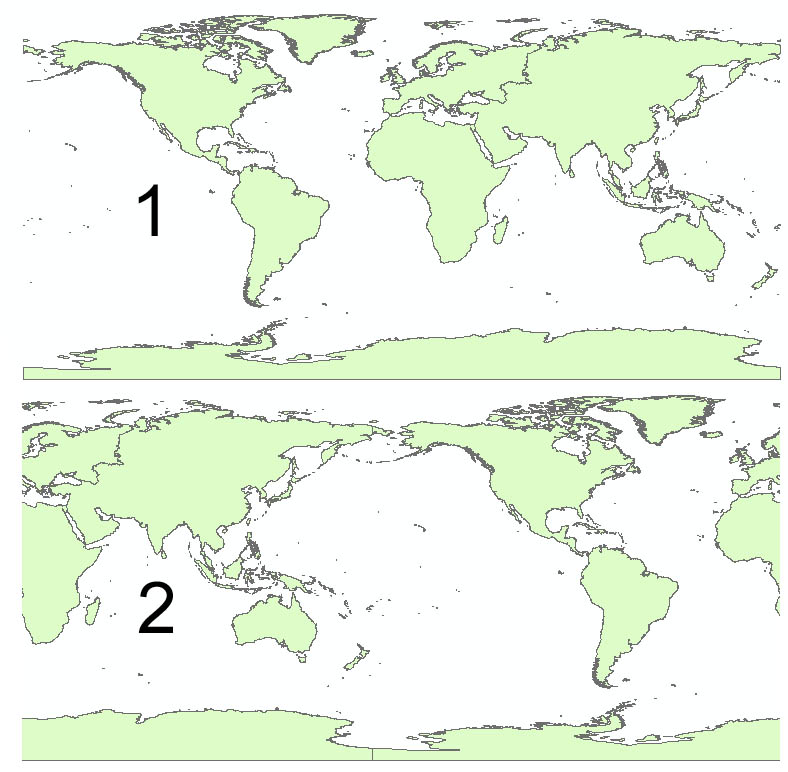
I want to view the map of the world to that the centre is at 180 degrees instead of zero - as discussed by Chris Fox in this post https://community.esri.com/ideas/1132 . He mentions that this can be done by customising the spatial reference but I can't find the controls to do it - can someone walk me through it?
i.e. so my map looks like 2 instead of 1.
Solved! Go to Solution.
Accepted Solutions
- Mark as New
- Bookmark
- Subscribe
- Mute
- Subscribe to RSS Feed
- Permalink
- Report Inappropriate Content
Thanks - got there in the end.
Dan's method seems to refer to v8 & 9 - my Catalogue tab doesn't seem to metion coordinate systems.
The "Copy and Modify" method was not sufficiently intuitive for me so, for anyone else with this question, here's what I did:
1. Make a new copy of WGS84.prj in windows explorer
2. Open it in a text editor and change the prime meridian to 180.
3. In the Coordinate system tab of the Dataframe properties click on little globe symbol and Import...
4. Select Transformations, then New... and change the "X Axis Translation (meters)" to 180.
note: this give the desired 180 degree translation even though the dialog suggests that the translation is in metres.
and I don't understand why you have to change the prime meridian and set a translation...
- Mark as New
- Bookmark
- Subscribe
- Mute
- Subscribe to RSS Feed
- Permalink
- Report Inappropriate Content
- Mark as New
- Bookmark
- Subscribe
- Mute
- Subscribe to RSS Feed
- Permalink
- Report Inappropriate Content
Hi Ben,
I believe since at least 10.1 you can open the Data Frame properties, go to the coordinate system tab, right-click the projection you want and choose "Copy and Modify". Here, you can re-name the projection and alter the Central Meridian property to 180.
- Mark as New
- Bookmark
- Subscribe
- Mute
- Subscribe to RSS Feed
- Permalink
- Report Inappropriate Content
Thanks - got there in the end.
Dan's method seems to refer to v8 & 9 - my Catalogue tab doesn't seem to metion coordinate systems.
The "Copy and Modify" method was not sufficiently intuitive for me so, for anyone else with this question, here's what I did:
1. Make a new copy of WGS84.prj in windows explorer
2. Open it in a text editor and change the prime meridian to 180.
3. In the Coordinate system tab of the Dataframe properties click on little globe symbol and Import...
4. Select Transformations, then New... and change the "X Axis Translation (meters)" to 180.
note: this give the desired 180 degree translation even though the dialog suggests that the translation is in metres.
and I don't understand why you have to change the prime meridian and set a translation...