- Home
- :
- All Communities
- :
- Products
- :
- ArcGIS Online
- :
- ArcGIS Online Questions
- :
- Hosted Map Service displays black tiles below a ce...
- Subscribe to RSS Feed
- Mark Topic as New
- Mark Topic as Read
- Float this Topic for Current User
- Bookmark
- Subscribe
- Mute
- Printer Friendly Page
Hosted Map Service displays black tiles below a certain scale
- Mark as New
- Bookmark
- Subscribe
- Mute
- Subscribe to RSS Feed
- Permalink
- Report Inappropriate Content
I have a 5ft resolution DEM that is currently stored as a mosaic dataset with overviews. I am trying to publish it as a hosted map service in AGO. When I do, I keep all of the default settings; the caching options are shown below:

After the service is published, these same scales are listed in the Manage Map Server Cache Tiles tool display:

Given these results, I assume that I should be able to see the cache when zoomed in to, say, 1:5,000. However, this is not the case. When I zoom in beyond 1:13,542, the entire service turns black.
Here is the service in ArcGIS for Desktop 10.3.1 at 1:13,542:

Here is the same service at 1:13,541:

The same thing happens when I open the service in MapViewer.
What is going wrong? Am I misunderstanding how scales work with caches? Does it have something to do with the fact that the information is being stored in a mosaic dataset? What piece of the puzzle am I missing?
Thanks for any and all help!
Solved! Go to Solution.
Accepted Solutions
- Mark as New
- Bookmark
- Subscribe
- Mute
- Subscribe to RSS Feed
- Permalink
- Report Inappropriate Content
How are level 16 and 17 smaller in size than level 15? There seems the issue.
Also don't burn your credits creating tiles directly in AGOL. Use this methodology Publish a Tiled Service to ArcGIS Online w/o ArcGIS for Server or Utilizing Your Credits
Think Location
- Mark as New
- Bookmark
- Subscribe
- Mute
- Subscribe to RSS Feed
- Permalink
- Report Inappropriate Content
Check the Cache completion status. I suspect the caching is incomplete.
View cache completion status—Documentation | ArcGIS for Server
Think Location
- Mark as New
- Bookmark
- Subscribe
- Mute
- Subscribe to RSS Feed
- Permalink
- Report Inappropriate Content
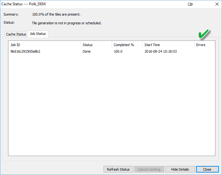
Thanks for the fast response! The cache status reports that 100% of the tiles are present:

And no errors are reported in the Job Status window:
- Mark as New
- Bookmark
- Subscribe
- Mute
- Subscribe to RSS Feed
- Permalink
- Report Inappropriate Content
How are level 16 and 17 smaller in size than level 15? There seems the issue.
Also don't burn your credits creating tiles directly in AGOL. Use this methodology Publish a Tiled Service to ArcGIS Online w/o ArcGIS for Server or Utilizing Your Credits
Think Location
- Mark as New
- Bookmark
- Subscribe
- Mute
- Subscribe to RSS Feed
- Permalink
- Report Inappropriate Content
Good eye. Thanks for catching that! There doesn't seem to be anything I can do, then. Is this is a bug with tiling in ArcGIS Online? In the meantime, I'll definitely be using the techniques in your link to try and get around the issue. I'll try and post back if I get the tiled service working correctly. Thanks again!
- Mark as New
- Bookmark
- Subscribe
- Mute
- Subscribe to RSS Feed
- Permalink
- Report Inappropriate Content
I was able to build the tile cache correctly using ArcGIS for Desktop, then transferred it to AGO as described in the link provided by Jayanta. As I can't rely on AGO to tile the data correctly, I'm going to be using this workflow in the future. Once again, thanks for you help!
- Mark as New
- Bookmark
- Subscribe
- Mute
- Subscribe to RSS Feed
- Permalink
- Report Inappropriate Content
A big Cheers to jskinner-esristaff for creating the wonderful document. 
Think Location