- Home
- :
- All Communities
- :
- Products
- :
- Mapping
- :
- Mapping Questions
- :
- Use Grids and Graticules to match the quad Index L...
- Subscribe to RSS Feed
- Mark Topic as New
- Mark Topic as Read
- Float this Topic for Current User
- Bookmark
- Subscribe
- Mute
- Printer Friendly Page
Use Grids and Graticules to match the quad Index Line. Is that possible ?
- Mark as New
- Bookmark
- Subscribe
- Mute
- Subscribe to RSS Feed
- Permalink
- Report Inappropriate Content
As I am going to work on my project for a few district office, I have a question for those you who have done this kind of Data Driven Pages or similar to it.
Here is the original map that I am suppose to copy or make some modification to it.. Here is the example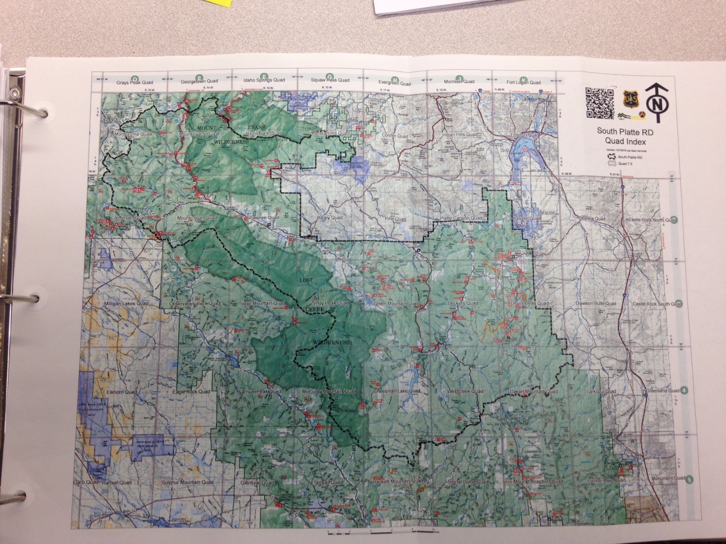
BUT when you zoom in closer here , I am trying to figure it HOW does the line goes across the tabs above, left, right and bottom of the layout ?

These lines are actually Quad index lines that can go through the Grid and Griducles margin to match the quad index lines ? Has anyone ever done this in the past ?
When I set them up to try and match exactly as it is and I do not see the line that can match the tabs . See here ..

I just wanted to see if anyone has done similar to it in the past.
- Mark as New
- Bookmark
- Subscribe
- Mute
- Subscribe to RSS Feed
- Permalink
- Report Inappropriate Content
One immediate thought would be to check the projection/coordinate system of the Data Frame versus the Quads. When I've made fieldmaps in the past that required a UTM grid overlaid on Quad maps, I've found that changing the Data Frame projection/coordinate system to match that of the Quads often resolves misalignment issues with the UTM lines and the UTM indexes shown on the Quad. However, I will say from practical experience that there always seems to be one or two quads in a map set where things are off a bit. The only conclusion that my colleagues and I could come up with at the time was the ones that were off were not scanned in precisely by the organization we received them from.
Chris Donohue, GISP
- Mark as New
- Bookmark
- Subscribe
- Mute
- Subscribe to RSS Feed
- Permalink
- Report Inappropriate Content
- Mark as New
- Bookmark
- Subscribe
- Mute
- Subscribe to RSS Feed
- Permalink
- Report Inappropriate Content
The tabs are part of a reference grid (aka index grid), which divides the frame edge into equal parts starting at the corner. The quad index lines are not tied to the frame and do not divide it up into equal parts from the corners. Moreover, the quad index lines are not exactly perpendicular/parallel to the frame. This means the grid and the lines will not match up, and there is no way to edit the reference grid to match the quad lines.
You will either need to draw tabs to match up using graphics (you could start with the index grid and convert it to graphics, then ungroup and edit the result), which won't be dynamic of course, or you may be able to use a custom overlay grid to label the edges with letters and numbers. To do that you will need a polygon feature class with an attribute for the letters and numbers (it may need 2 sets of features and 2 overlay grids, one for the rows and one for the columns). See Adding a Custom Overlay Grid in the help.
(meant to reply to the original post, not to Dan!)
- Mark as New
- Bookmark
- Subscribe
- Mute
- Subscribe to RSS Feed
- Permalink
- Report Inappropriate Content
Thank you everyone for your help. After I did spend some time, I do realized that it is NOT possible to do that as what others have said.
I kept looking at the map above that I posted and thought that the person who did this did not use any special or anything.
I believe that he just use the scanned up and created lines to match the latitude and Longitude (Shown in grey collor) and it is hard to read.
I tried to use the Grid and Griducles and I realized that it is NOT possible to do that in a very limited of my time and I have to do this 36 different maps for 6 Ranger District here.