- Home
- :
- All Communities
- :
- Products
- :
- ArcGIS GeoEvent Server
- :
- ArcGIS GeoEvent Server Questions
- :
- How do you create a simple geofence that sends an ...
- Subscribe to RSS Feed
- Mark Topic as New
- Mark Topic as Read
- Float this Topic for Current User
- Bookmark
- Subscribe
- Mute
- Printer Friendly Page
How do you create a simple geofence that sends an email when for example a hurricane track intersects it ?
- Mark as New
- Bookmark
- Subscribe
- Mute
- Subscribe to RSS Feed
- Permalink
- Report Inappropriate Content
Im very new to ArcGIS GeoEvent Manager.
I have a Hurricane live feed from NOAA, I want to create an application that sends an email when the hurricane cone of influence intersects with a point buffer.
Seems simple enough. However trying to figure out how to actually implement this in GeoEvent Manager does not appear easy.
Is there a guide other than the tutorials (not much use in my opinion) that actually shows you how to do this ? It was mentioned in a seminar I viewed online, but they didn't actually show you how to do it.
Regards.
Jeremy.
- Mark as New
- Bookmark
- Subscribe
- Mute
- Subscribe to RSS Feed
- Permalink
- Report Inappropriate Content
Hi Jeremy,
Some questions to start with:
1. Do you have the hurricane feed actively working in GeoEvent, so that you see an incrementing "Count" in the Monitor tab of GeoEvent Manager?
2. Are the geoevents in this feed points or polygons (cones)?
3. The points to be buffered - are they geoevents themselves, or static points that already exist? Or do the buffers exist?
Mark
- Mark as New
- Bookmark
- Subscribe
- Mute
- Subscribe to RSS Feed
- Permalink
- Report Inappropriate Content
Morning Mark.
Many thanks for getting back to me. Regarding your questions
1. No I do not have the Hurricane feed running in GEoEvent Server yet. I get an error (‘<’ Unexpected symbol) when I try to register the service.
2. They are points and polygons, but I only need to create geofences around the points I suppose. The streaming service is here http://livefeeds.arcgis.com/arcgis/rest/services/LiveFeeds/Hurricane_Active/MapServer can you access it ?
3. Just static points at the moment. What’s the best thing to do, geofence the static points or the live feed ?
4. I was under the impression you could just do this. Consume the live feed, upload some buffered points, when the live feed intersects with the buffered points, send an email.
I don’t really know the best way to go about doing this to be honest. Going through the tutorials doesn’t really get me any further forward as I can’t actually register the live feed, or if I import it as an input it doesn’t run.
Regards.
Jeremy.
- Mark as New
- Bookmark
- Subscribe
- Mute
- Subscribe to RSS Feed
- Permalink
- Report Inappropriate Content
I can physically see the service endpoint (i.e. no firewall is blocking me) but I get prompted for a token. I follow the link it presents to get one, but I then get a blank page with just an "API reference" link.
You can either geofence the items in the live feed or import buffered static points as geofences. Both are viable options.
Option 1. If you have static points, you can buffer them in ArcMap, then serve out the buffers as a feature service. You register a "Data Store" (ArcGIS Server, Portal, or ArcGIS Online) in GeoEvent Manager that points to that instance, then you will have access to the buffer layer when setting up any filter or processor that needs to use those buffers as a geofence.
Option 2. You could just serve out the points layer as a feature service. Register the data store the same way, then you will have access to the points layer the same way. The only difference is that you'll need to buffer the geoevents, then use that polygon in your filter or processor to do your spatial operation. They both can get you what you want, just using two different logical approaches.
In case #1 you have geoevent *points* you use with an "INSIDE" operation when comparing to *polygon* geofences (the polygons in the feature service), whereas in case #2, you have geoevent buffer *polygons* you use with a "CONTAINS" operation when comparing to *point* geofences (the points in the feature service). You can do exactly what you want, it's just a matter of piecing it together. I know your question is still unanswered, but I'm trying to lay out general concepts. If you can get me a link to a feed I can see, I can list out the exact steps you need to do.
In the meantime, here is a video from UC that you may want to check out. I haven't watched the whole thing but upon skimming it, I noticed some setting up of inputs, and setting up of some geofencing.
- Mark as New
- Bookmark
- Subscribe
- Mute
- Subscribe to RSS Feed
- Permalink
- Report Inappropriate Content
Hi Mark,
Many many thanks for the excellent instruction. I had a long conversation with ESRI yesterday and it turns out that the feed I was trying to use can’t be used in this way with GeoEvent as it’s not a true feature service but an image service so the actual data isn’t available.
So I’m back to square one really. As you say if we had a feed we could actually use that would be a start. And I’d be happy to point you to one, but I can’t find one that would work in GeoEvent. I’m also a little confused about what sort of feed we are exactly looking for. I assume it is a pure feature service. Do you think any of these would work ?
http://idpgis.ncep.noaa.gov/arcgis/rest/services/NWS_Forecasts_Guidance_Warnings
As you can see I am looking for hurricane feeds really, but now just anything that will work in GeoEvent. As these are all MapServer types I assume these also will not work.
Any thoughts.
Regards.
Jeremy,
Jeremy Dunn MSc, Spatial Analytics Specialist, Analytics Technology
Willis Towers Watson, The Willis Towers Watson Building, 51 Lime Street, London, EC3M 7DQ, United Kingdom
Jeremy.Dunn@willis.com<mailto:Jeremy.Dunn@willis.com>, www.willis.com
- Mark as New
- Bookmark
- Subscribe
- Mute
- Subscribe to RSS Feed
- Permalink
- Report Inappropriate Content
Hi Mark,
OK can you see if you can use any one of these “feeds”. I guess I’m interested to know which would be best in terms of what I want to do.
Which as you know is simply to intersect the feed with a buffered point and send an email once this happens.
Which one of these formats would give the most stable and simple environment to work with.
I’ve successfully input the GeoJSON feed but don’t seem to get any through put from my service. Although I don’t know if my service is set up correctly. I don’t get any errors but that doesn’t mean it’s working.
https://data.noaa.gov/dataset/noaa-national-hurricane-center-tropical-cyclone-forecasts-wms-wfsf4982
Regards.
Jeremy.
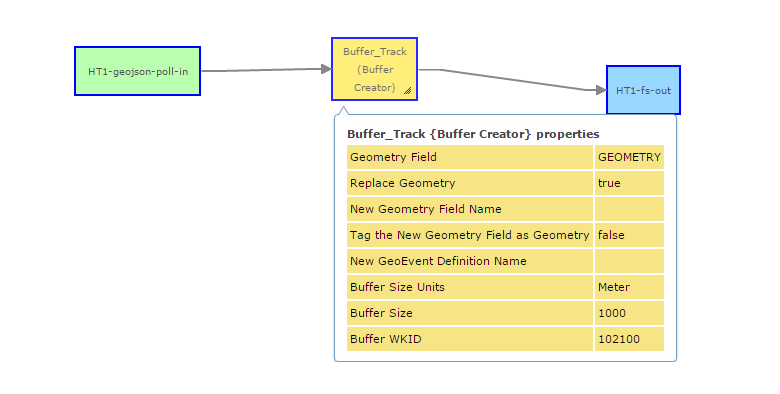
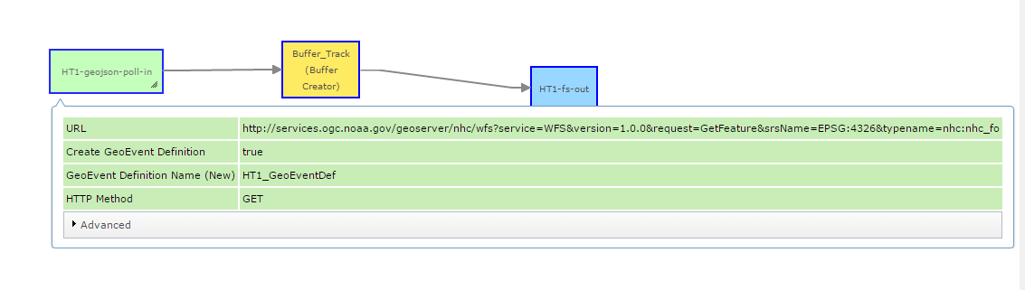
Here’s my attempt at creating a service
My question is, does this service buffer my hurricane points with 1000m buffer ? Does the output go to my service Hunch_Airports1 ?
Doesn’t look like anything happens.
Jeremy Dunn MSc, Spatial Analytics Specialist, Analytics Technology
Willis Towers Watson, The Willis Towers Watson Building, 51 Lime Street, London, EC3M 7DQ, United Kingdom
Jeremy.Dunn@willis.com<mailto:Jeremy.Dunn@willis.com>, www.willis.com
- Mark as New
- Bookmark
- Subscribe
- Mute
- Subscribe to RSS Feed
- Permalink
- Report Inappropriate Content
Jeremy,
I apologize for not seeing your message. Either I do not have my GeoNet notifications set up properly, or GeoNet notifications suck. I did not realize you replied until I just clicked on this message thread. I doubt your original use case is still in effect, but if you want to keep talking GeoEvent, email me at mbramer@esri.com.
Mark