- Home
- :
- All Communities
- :
- Industries
- :
- State & Local Government
- :
- State & Local Government Questions
- :
- Has anyone had to draw a public notification buffe...
- Subscribe to RSS Feed
- Mark Topic as New
- Mark Topic as Read
- Float this Topic for Current User
- Bookmark
- Subscribe
- Mute
- Printer Friendly Page
Has anyone had to draw a public notification buffer that excludes right of way?
- Mark as New
- Bookmark
- Subscribe
- Mute
- Subscribe to RSS Feed
- Permalink
- Report Inappropriate Content
Our City code says that the buffer should be 500' not including rights of way. I can't think of a way to standardize this.
- Mark as New
- Bookmark
- Subscribe
- Mute
- Subscribe to RSS Feed
- Permalink
- Report Inappropriate Content
A few questions to help clarify the issue:
- Does your organization have Right-of-Way (ROW) polygons stored either in a parcel layer or a regular feature class?
- Which software are you using to accomplish this? ArcGIS? ArcGIS Online? Another?
- What version of the software?
- Is it a specific tool/process that already exists that you are encontering this issue with (like something from the Local Government Information Model (LGIM)) or is this a brand new set of functionality you want to create?
- Based on your CIty Code, what is the basis of where the buffer starts? Is it a parcel boundary and then 500 feet out, the center of a parcel and then 500 feet out, or another basis?
Our city uses a parcel layer for public notifications that has all the ROW stripped out prior to running the buffers. However, that said, I've noticed other municipalities have a different combination of data and process. So I guess solving this comes down to "what have you got to work with" and then "how do you want to get there given what is available."
Chris Donohue, GISP
- Mark as New
- Bookmark
- Subscribe
- Mute
- Subscribe to RSS Feed
- Permalink
- Report Inappropriate Content
Thanks Chris.
- We do not have ROW polygons. We have a legal property line layer and a matching parcel layer for assessor's parcels.
- I am using ArcGIS Desktop but I could use Online or Pro.
- version 10.4.1
- In the past I have used the buffer tool to draw a polygon 500 feet out from the boundary of the parcel. I just found out that I am supposed to exclude ROW.
I'm not really sure how that could be done aside from just estimation. Is it possible to configure the buffer tool to account for ROW?
- Mark as New
- Bookmark
- Subscribe
- Mute
- Subscribe to RSS Feed
- Permalink
- Report Inappropriate Content
My very first thought would be to do it the way you said you did it in the past. I.e,. buffer the selected polygon 500 feet and then find all the parcels that intersect that. With this process the intersected ones would become the ones you need to notify.
But after re-reading your question I think what is going on is that you are saying the selected parcel needs to be buffered 500' and that distance needs to exclude from the measurement any ROW traversed as part of the 500 foot distance part. In other words, going away from the selected parcel we start to measure across parcels but whenever we traverse a ROW we stop increasing the measurement and only continue it once we are traversing parcels again. So a parcel 590 feet away from your selected parcel would be notified it in the traverse to it a 100 foot ROW was crossed (which does not count towards the 500 ft notification distance). In short, it is not a simple 500 foot buffer to solve this. So the goal will be to find a process that measures 500 feet out from a polygon to find all other non-ROW polygons by intentionally excluding from the 500ft distance any ROW polygons crossed.
Can you confirm if I theorized this correctly? If this is the case I don't immediately know the answer to this, but am sure with the talent on GeoNet we can find a solution. Let me know if I got the issue correct and/or if there is another aspect to it.
Chris Donohue, GISP
- Mark as New
- Bookmark
- Subscribe
- Mute
- Subscribe to RSS Feed
- Permalink
- Report Inappropriate Content
Yes Chris, you got it correct. It's not so hard when the ROW is parallel to the property. You could just add the width of the ROW to the buffer. But most of the time roads intersect the buffer at different angles and may not be a uniform width.
Thank you for your suggestions below! I'm starting to think of the problem in new ways.
Cindy
- Mark as New
- Bookmark
- Subscribe
- Mute
- Subscribe to RSS Feed
- Permalink
- Report Inappropriate Content
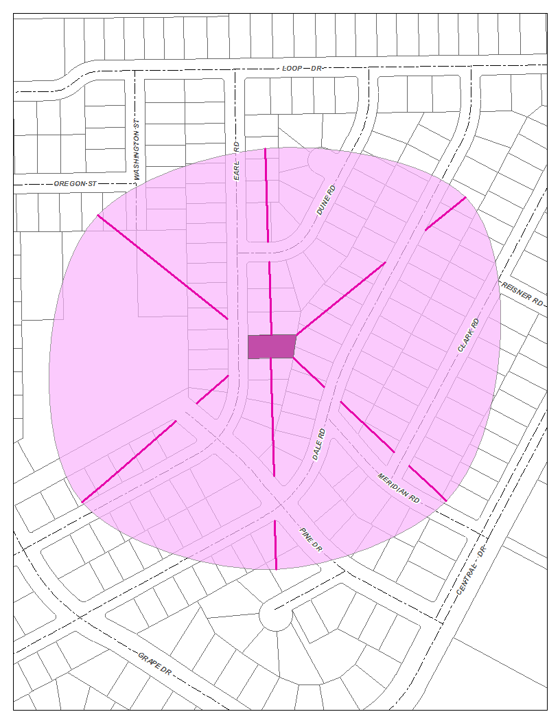
Here's my basic idea: I drew 500' lines radiating from the parcel. Then I broke out the parts of the lines that crossed a road and added them to the end of the line. I drew the buffer by just connecting the endpoints of the new lines and smoothing the resulting polygon.
- Mark as New
- Bookmark
- Subscribe
- Mute
- Subscribe to RSS Feed
- Permalink
- Report Inappropriate Content
A couple of follow-up questions:
- Will an actual buffer line need to be created (for later depiction) or is it sufficient to just select the parcels within 500' (without counting ROW crossed) without showing the buffer line?
- Does the process need to be automated?
Chris Donohue, GISP
- Mark as New
- Bookmark
- Subscribe
- Mute
- Subscribe to RSS Feed
- Permalink
- Report Inappropriate Content
- I don't think the buffer line would need to be shown. I would probably just highlight the affected parcels.
- The process doesn't need to be automated. I'd like to find a good balance between time and accuracy though.
Cindy
- Mark as New
- Bookmark
- Subscribe
- Mute
- Subscribe to RSS Feed
- Permalink
- Report Inappropriate Content
If you have an Advanced ArcGIS license, here's most of the workflow. However, note the very last step (#6) needs some work still.
1. Select your parcel to do the notification from and save it as a separate feature class.
2. Run Generate Near Table (note: requires an Advanced ArcGIS license)
- Use a search radius like 1000ft to ensure it captures parcels but does not try to do all the distances to every parcel in your database.
- Change the default checkboxes: Location should be checked, Angle should be checked, Find only closest feature should be unchecked.
http://pro.arcgis.com/en/pro-app/tool-reference/analysis/generate-near-table.htm (this is the Pro help, but the ArcGIS Desktop help is the same).
3. Run XY to Line using the table created in Generate Near Table as the input. This will generate a line feature class.
http://pro.arcgis.com/en/pro-app/tool-reference/data-management/xy-to-line.htm
4. Create a feature class of just the Right of Way (ROW) polygons in the vicinity.
5. Run Erase (Analysis) (requires an Advanced license) to remove the ROW from the lines, leaving only lines across parcels.
http://pro.arcgis.com/en/pro-app/tool-reference/data-management/xy-to-line.htm
6. First, calculate the distance of each line. Then find the ones that are 500 feet long or less and save them off as a separate feature class. Then use a Select by Location with this Line feature class to select the parcels that qualify. *****However, the Select by Location did not successfully find parcels just across a Right of Way, so this last bit needs work.***** (somehow part of the line is getting dropped, so of course there is nothing to use for a selection).

There may be a few other kinks to work out, but I think this process would work. Once it is workable, one could probably use Modelbuilder to automate it, or even better, Python. For the latter, we'd need some of the experts in Python to weigh in (not me).
Chris Donohue, GISP
- Mark as New
- Bookmark
- Subscribe
- Mute
- Subscribe to RSS Feed
- Permalink
- Report Inappropriate Content
Thanks so much for your help Chris. Unfortunately I don't have an advanced ArcGIS license. I can see that this is going to be a complicated process however I approach it. My strategy for now is going to be requiring the planners to define the notification area until I can develop an effective solution. In this way I can remove liablility from the GIS department. I'll post here if I figure something out.
Cindy