- Home
- :
- All Communities
- :
- Products
- :
- 3D
- :
- 3D Mapping Questions
- :
- Newbie questions
- Subscribe to RSS Feed
- Mark Topic as New
- Mark Topic as Read
- Float this Topic for Current User
- Bookmark
- Subscribe
- Mute
- Printer Friendly Page
Newbie questions
- Mark as New
- Bookmark
- Subscribe
- Mute
- Subscribe to RSS Feed
- Permalink
- Report Inappropriate Content
I am a Newbie to Arcgis, but a seasoned Autocad user.
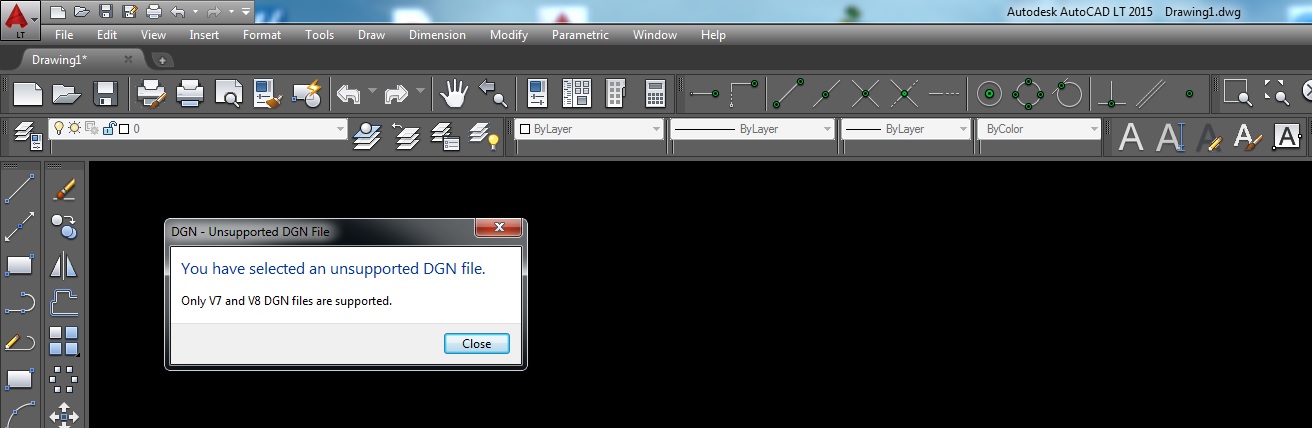
Recently I received files with extensions .aux, .tiff, .tfw, .tab, .rrd, but I cannot import these files into Autocad as it tells me it will only import version 7 & 8 files - so I am snookered.
I have downloaded a demo version of Arcmap and Arcgis and need some help to steer me in the right direction.
THe first problem I encountered is that it asks me to register a service or server. I have no idea whether this is part of a project or only for using external servers for other users.
I will be using these programs on my own PC and I would like to save all the data on this PC and not share with anyone.
What are the basic steps that I should go through to import map data or make a new map with geograhical data.
My application is to put contours and lat and long on a part of Google Earth of South Africa - and to enhance the map with 3D colours of the contours.
I do not even know if I am on the right forum, but it seems to be active - so please bear with me.
Thanks
PK
- Mark as New
- Bookmark
- Subscribe
- Mute
- Subscribe to RSS Feed
- Permalink
- Report Inappropriate Content
Could you provide a screenshot of the error message (from ArcGIS)?
Think Location
- Mark as New
- Bookmark
- Subscribe
- Mute
- Subscribe to RSS Feed
- Permalink
- Report Inappropriate Content
- Mark as New
- Bookmark
- Subscribe
- Mute
- Subscribe to RSS Feed
- Permalink
- Report Inappropriate Content
- Mark as New
- Bookmark
- Subscribe
- Mute
- Subscribe to RSS Feed
- Permalink
- Report Inappropriate Content
You could use Imagery with Labels/Streets or other basemaps in ArcMap as background(Add Basemap option).

And you could convert the data to KML (Layer to KML) to open it on Google Earth. Layer To KML—Help | ArcGIS for Desktop
But to align your data either with the Basemap in ArcMap or in Google Earth, the data must be georeferenced. Fundamentals of georeferencing a raster dataset—Help | ArcGIS for Desktop
From the error (ArcMap Error.jpg), I can say that the data is not georeferenced or lacks coordinate system.
Think Location