- Home
- :
- All Communities
- :
- Products
- :
- ArcGIS Spatial Analyst
- :
- ArcGIS Spatial Analyst Questions
- :
- how can i generate contours using point data?
- Subscribe to RSS Feed
- Mark Topic as New
- Mark Topic as Read
- Float this Topic for Current User
- Bookmark
- Subscribe
- Mute
- Printer Friendly Page
how can i generate contours using point data?
- Mark as New
- Bookmark
- Subscribe
- Mute
- Subscribe to RSS Feed
- Permalink
- Report Inappropriate Content
Hi guys
Can i ask for the procedures in generating contours using point data? I'm actually using the spatial analyst but the result is not that good.
- Mark as New
- Bookmark
- Subscribe
- Mute
- Subscribe to RSS Feed
- Permalink
- Report Inappropriate Content
the background is here An overview of the Raster Interpolation toolset—Help | ArcGIS Desktop here Understanding interpolation analysis—Help | ArcGIS Desktop and here Comparing interpolation methods—Help | ArcGIS Desktop The last link exposes a whole variety of other links appropriate to the interpolation method. Just follow the links to the one that is interested.
Key points to remember
- choose a cell size representing you inter-point spacing appropriately, just don't omit it since you will end up with poor results.
- you points shouldn't be clustered into groups... any interpolation method will do poorly in that situation... ie there shouldn't be huge gaps between the points with small groups of the points... well spread out is best
- you need an 'appropriate number of points to begin with.
Interpolation is part art and part science.... you may need to experiment once you understand how the interpolators function on a mathematical level.
- Mark as New
- Bookmark
- Subscribe
- Mute
- Subscribe to RSS Feed
- Permalink
- Report Inappropriate Content
Some excellent links provided by Dan Patterson
What have you tried so far and what makes you say that the result was "not that good"?
I also think a few pictures helps. So here is an old esri pdf on interpolation.
- Mark as New
- Bookmark
- Subscribe
- Mute
- Subscribe to RSS Feed
- Permalink
- Report Inappropriate Content
I had to do this not too long ago with fc with a lot of mass points, and I also had break lines.
Kept running out of memory or not finishing process, even after splitting it up several times.
Then, I created a terrain dataset using the mass points and break lines as input. Cranked it out in no time, then I dumped it out to a DEM/raster with the TerrainToRaster tool then ran the spatial analyst Contour tool to generate contours.
Came out nicely and waaaaay faster than trying to process the fc's individually.
What is a terrain dataset?—Help | ArcGIS for Desktop
R_
- Mark as New
- Bookmark
- Subscribe
- Mute
- Subscribe to RSS Feed
- Permalink
- Report Inappropriate Content
Kernel Interpolation with Barriers won't run out of memory.
-Steve
- Mark as New
- Bookmark
- Subscribe
- Mute
- Subscribe to RSS Feed
- Permalink
- Report Inappropriate Content
I don't see the result "contour lines" , but I think the result is not good because cell size of raster.
so if you have a standard or advanced license you can use Smooth Line to get better result .
- Mark as New
- Bookmark
- Subscribe
- Mute
- Subscribe to RSS Feed
- Permalink
- Report Inappropriate Content
You should never smooth the contour lines. You could end up with overlapping lines.
Rather smooth the raster and re-contour it.
-Steve
- Mark as New
- Bookmark
- Subscribe
- Mute
- Subscribe to RSS Feed
- Permalink
- Report Inappropriate Content
I tried to smooth contour line using Smooth line tool.
the DEM cell size is : 18 meter
the minimum distance between two close contour lines is : 3.3 meter
Using BEZIER_INTERPOLATION in Smoothing Algorithm
I didn't get overlapping lines.
Using PAEK in Smoothing Algorithm
I didn't get overlapping lines in 3 meter Smoothing Tolerance.
I didn't get overlapping lines in 18 meter Smoothing Tolerance.
I get 1 overlapping line in 50 meter Smoothing Tolerance.
- Mark as New
- Bookmark
- Subscribe
- Mute
- Subscribe to RSS Feed
- Permalink
- Report Inappropriate Content
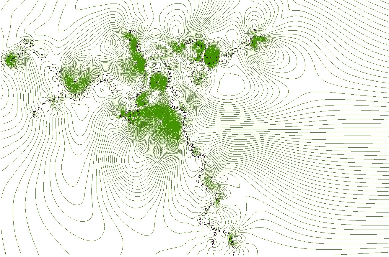
This is how my contour goes. I was expecting to create a contour following the points on the map. Actually these points are controlled points surveyed using total station to generate contour lines along the river. Below was there output:

I was about to evaluate their output but unfortunately i cannot generate my own contour, they use Autocad software while i'm using ArcGIS.
One question is how can i choose a cell size? is it something to be calculated?
- Mark as New
- Bookmark
- Subscribe
- Mute
- Subscribe to RSS Feed
- Permalink
- Report Inappropriate Content
Well, I see a regular set of points with quite a large spacing, then little points with a very small clustering. You won't be able to see the contours if zoomed to full extent even if you use a small cell size, because of the clustering. If you use a larger cell size appropriate to the widely spaced points, the small clusters will be obliterated.
What do you want to show and at what map scale? There is no need to contour the whole map and have it apply at all scales, you can partition your data and interpolate and contour at a scale appropriate to it.