- Home
- :
- All Communities
- :
- Products
- :
- Mapping
- :
- Mapping Questions
- :
- Not visible layer
- Subscribe to RSS Feed
- Mark Topic as New
- Mark Topic as Read
- Float this Topic for Current User
- Bookmark
- Subscribe
- Mute
- Printer Friendly Page
Not visible layer
- Mark as New
- Bookmark
- Subscribe
- Mute
- Subscribe to RSS Feed
- Permalink
- Report Inappropriate Content
Hi all,
I have received an .mxd file with the geodatabase.
When I Repair the data source it seems to work, but many of the layers are not showing up (their table of attribute is full of details, so the data are there).
If I check all the not showed layer are under the "Not visible" list. When I click on them to make them visible, nothing change so I ma still not able to see them.
I am quite sure the data re alright as I tried to import them in a new blank .mxd file and there they are visible, so is it possible it is something set in the .mxd I have been provided? Any suggestion?
Thanks a lot
F
- Mark as New
- Bookmark
- Subscribe
- Mute
- Subscribe to RSS Feed
- Permalink
- Report Inappropriate Content
What happens if you right-click the layer > Zoom to layer? If the layer are visible after doing "zoom to layer", it could be an issue with the spatial reference of the layers.
Snapshots of the layer properties (Source tab) would help. Also mention what is the spatial reference of the layers that are not visible.
You could also check for any definition query that is no longer valid.
Think Location
- Mark as New
- Bookmark
- Subscribe
- Mute
- Subscribe to RSS Feed
- Permalink
- Report Inappropriate Content
If I zoom, it zoom in the area but I cannot see anything.
The layers seem to have spatial references.
please see the screenshot of the source tab
.png)
What do you mean by "
You could also check for any definition query that is no longer valid."??
cheers
F
- Mark as New
- Bookmark
- Subscribe
- Mute
- Subscribe to RSS Feed
- Permalink
- Report Inappropriate Content
Do you see any expression in Layer Properties > Definition Query?
You could also copy-paste all the layers to a new MXD. If the problem gets resolved, delete the old MXD and save the new MXD with the same name.
Think Location
- Mark as New
- Bookmark
- Subscribe
- Mute
- Subscribe to RSS Feed
- Permalink
- Report Inappropriate Content
The Definition query tab are blank.
I can do in a new mxd file but this means that I will loose all the layer set up (colors and symbols) from the project and it will require too much time for me to do them identical to the project.
Any suggestion on what could it be the problem why I cannot see the layer?
Cheers
F
- Mark as New
- Bookmark
- Subscribe
- Mute
- Subscribe to RSS Feed
- Permalink
- Report Inappropriate Content
If you copy-paste the layers from the Table of Content of one MXD to the Table of Content of another MXD, the symbology remains intact.


Alternatively, you could save the layers (in Table of Contents) as layer files (.lyr). Then add those lyr files to the new MXD.

Think Location
- Mark as New
- Bookmark
- Subscribe
- Mute
- Subscribe to RSS Feed
- Permalink
- Report Inappropriate Content
Thank you, very helpful. Still didn't get what is the problem. How is it possible the data are there and I cannot see them?
Bytheway it will make the job!
Thanks,
Francesca
- Mark as New
- Bookmark
- Subscribe
- Mute
- Subscribe to RSS Feed
- Permalink
- Report Inappropriate Content
It would be easy for me to put the blame on a corrupt MXD, but I am not sure though.
Glad things are working fine.
Think Location
- Mark as New
- Bookmark
- Subscribe
- Mute
- Subscribe to RSS Feed
- Permalink
- Report Inappropriate Content
Hi,
another frustrating problem. I saved as layer one of the data "isopachs" and I imported in a new mxd file. It works and looks fine. When I triy to do an interpolation (Topo to raster) with SA tool, it gives me an error (please see below)
.png)
Do you know which one could be the problem?
Thanks
F
- Mark as New
- Bookmark
- Subscribe
- Mute
- Subscribe to RSS Feed
- Permalink
- Report Inappropriate Content
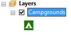
one more details about my not visible layer (just in case this means anything to you)
please see below what appears next to my not visible layers(picture below) and if I click on them the small "cylindrical" symbol disappear but the layer still doesn't became visible.
.png)
Does it make any sense?
Cheers
F