- Home
- :
- All Communities
- :
- Products
- :
- ArcGIS AppStudio
- :
- ArcGIS AppStudio Questions
- :
- Address Locator error on Online Geocode service
- Subscribe to RSS Feed
- Mark Topic as New
- Mark Topic as Read
- Float this Topic for Current User
- Bookmark
- Subscribe
- Mute
- Printer Friendly Page
Address Locator error on Online Geocode service
- Mark as New
- Bookmark
- Subscribe
- Mute
- Subscribe to RSS Feed
- Permalink
- Report Inappropriate Content
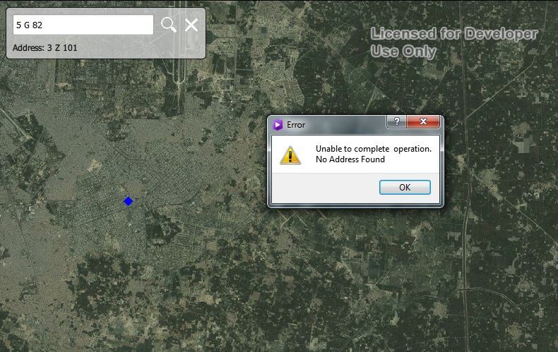
I am using my owned prepared locator Geocode service (http://maps.dhalahore.org/ArcGIS/rest/services/DHAMAP/AddressLocator/GeocodeServer) in Geocode online (arcgis-appstudio-samples-master).
Working perfect on Reverse Geocoding but giving Error (Unable to complete operation. No Address Found) when i search any address in search box.
Here code:
import QtQuick 2.3
import QtQuick.Controls 1.2
import QtQuick.Dialogs 1.2
import QtPositioning 5.3
import ArcGIS.AppFramework 1.0
import ArcGIS.AppFramework.Controls 1.0
import ArcGIS.AppFramework.Runtime 1.0
import ArcGIS.AppFramework.Runtime.Controls 1.0
import ArcGIS.AppFramework.Runtime 1.0
App {
id: app
width: 800
height: 532
property double scaleFactor: AppFramework.displayScaleFactor
property string errorMsg
Map {
id: mainMap
anchors.fill: parent
extent: usExtent
focus: true
ArcGISTiledMapServiceLayer {
url: "http://server.arcgisonline.com/ArcGIS/rest/services/World_Street_Map/MapServer"
}
SimpleMarkerSymbol {
id: simpleMarkerSymbolLocation
color: "red"
style: Enums.SimpleMarkerSymbolStyleCross
size: 10
}
SimpleMarkerSymbol {
id: simpleMarkerSymbolReverseLocation
color: "blue"
style: Enums.SimpleMarkerSymbolStyleDiamond
size: 10
}
GraphicsLayer {
id: graphicsLayerGeocode
}
GraphicsLayer {
id: graphicsLayerReverse
}
Graphic {
id: locationGraphicReverse
symbol: simpleMarkerSymbolReverseLocation
}
Graphic {
id: locationGraphicGeocode
symbol: simpleMarkerSymbolLocation
}
Envelope {
id: usExtent
xMax: -15000000
yMax: 2000000
xMin: -7000000
yMin: 8000000
spatialReference: mainMap.spatialReference
}
onMouseClicked: {
graphicsLayerReverse.removeAllGraphics();
var graphic1 = locationGraphicReverse.clone();
graphic1.geometry = mouse.mapPoint;
graphicsLayerReverse.addGraphic(graphic1);
locator.reverseGeocode(mouse.mapPoint, 500, mainMap.spatialReference);
}
}
ServiceLocator {
id: locator
url: "http://maps.dhalahore.org/ArcGIS/rest/services/DHAMAP/AddressLocator/GeocodeServer"
onFindStatusChanged: {
if (findStatus === Enums.FindStatusCompleted) {
progressBar.visible = false;
if (findResults.length < 1) {
showError("No address Found");
} else {
for (var i = 0; i < findResults.length; i++) {
var result = findResults;
var graphic = locationGraphicGeocode.clone()
graphic.geometry = result.location;
graphicsLayerGeocode.addGraphic(graphic);
}
mainMap.zoomTo(graphic.geometry);
}
} else if (findStatus === Enums.FindStatusErrored) {
progressBar.visible = false;
showError(findError.message + "\nNo Address Found");
}
}
onReverseGeocodeStatusChanged: {
if (reverseGeocodeStatus === Enums.ReverseGeocodeStatusCompleted) {
searchBox.descriptionTextVisibility = true;
searchBox.descriptionTextInput = "Address: "
var address = reverseGeocodeResult.addressFields["Address"];
var city = reverseGeocodeResult.addressFields["City"];
var state = reverseGeocodeResult.addressFields["Region"];
var zip = reverseGeocodeResult.addressFields["Postal"];
searchBox.descriptionTextInput += address + " " + city + ", " + state + " " + zip;
} else if (reverseGeocodeStatus === Enums.ReverseGeocodeStatusErrored) {
showError(reverseGeocodeError.message + "\nNo Address Found");
searchBox.descriptionTextVisibility = false;
}
}
}
LocatorFindParameters {
id: findTextParams
text: searchBox.searchTextInput
outSR: mainMap.spatialReference
maxLocations: 1
searchExtent: usExtent
sourceCountry: "US"
}
/*-----------------------------------------------------------------------------------------------------------------------
Search button / box
---------------------------------------------------------------------------------------------------------------------*/
SearchBox {
id: searchBox
anchors {
left: parent.left
top: parent.top
margins: 20 * scaleFactor
}
onSearch: {
findTextParams.text = searchBox.searchTextInput
graphicsLayerGeocode.removeAllGraphics();
locator.find(findTextParams);
progressBar.visible = true;
}
onClear: {
mainMap.extent = usExtent;
mainMap.mapRotation = 0;
graphicsLayerGeocode.removeAllGraphics();
graphicsLayerReverse.removeAllGraphics();
searchBox.descriptionTextInput = "";
searchBox.searchTextInput.focus = true;
searchBox.descriptionTextVisibility = false;
searchBox.searchTextInput = "";
}
Keys.onReturnPressed: {
findTextParams.text = searchBox.searchTextInput
graphicsLayerGeocode.removeAllGraphics();
locator.find(findTextParams);
progressBar.visible = true;
Qt.inputMethod.hide();
}
}
Row {
anchors {
horizontalCenter: parent.horizontalCenter
bottom: mainMap.bottom
bottomMargin: 5 * scaleFactor
}
ProgressBar {
id: progressBar
indeterminate: true
visible: false
}
}
MessageDialog {
id: messageDialog
title: "Error"
icon: StandardIcon.Warning
modality: Qt.WindowModal
standardButtons: StandardButton.Ok
text: errorMsg
}
Rectangle {
id: rectangleBorder
anchors.fill: parent
color: "transparent"
border {
width: 0.5 * scaleFactor
color: "black"
}
}
function showError(errorString) {
errorMsg = errorString;
messageDialog.visible = true;
}
}
Any Info would be greatly appreciated.
Cheers,
"Tasadduq Hussain" 
Solved! Go to Solution.
Accepted Solutions
- Mark as New
- Bookmark
- Subscribe
- Mute
- Subscribe to RSS Feed
- Permalink
- Report Inappropriate Content
Hi there, There are couple of issues here, directly related to your Geocoding service. 1) Your geocoding service is based on server 10.0 and hence only supports FindAddressCandidates. Therefore you should be usinglocator.geocode() method to perform Geocoding. This method calls the FindAddressCandidates operation 2) Based on your service address field. It currently takes Single Address labelled as "SingleKey". Hence you should only use that as your Address field parameter. I have added these suggestions in your code and pasted below for your reference. I hope this helps. Thank you. Nakul
App {
id: app
width: 800
height: 532
property double scaleFactor: AppFramework.displayScaleFactor
property string errorMsg
Map {
id: mainMap
anchors.fill: parent
extent: usExtent
focus: true
ArcGISTiledMapServiceLayer {
url: "http://server.arcgisonline.com/ArcGIS/rest/services/World_Street_Map/MapServer"
}SimpleMarkerSymbol {
id: simpleMarkerSymbolLocation
color: "red"
style: Enums.SimpleMarkerSymbolStyleCross
size: 10
}SimpleMarkerSymbol {
id: simpleMarkerSymbolReverseLocation
color: "blue"
style: Enums.SimpleMarkerSymbolStyleDiamond
size: 10
}GraphicsLayer {
id: graphicsLayerGeocode
}GraphicsLayer {
id: graphicsLayerReverse
}Graphic {
id: locationGraphicReverse
symbol: simpleMarkerSymbolReverseLocation
}Graphic {
id: locationGraphicGeocode
symbol: simpleMarkerSymbolLocation
}Envelope {
id: usExtent
xMax: 8380686
yMax: 3594113
xMin: 8180686
yMin: 3794113
spatialReference: mainMap.spatialReference
}onMouseClicked: {
graphicsLayerReverse.removeAllGraphics();
var graphic1 = locationGraphicReverse.clone();
graphicsLayerReverse.addGraphic(graphic1);
graphic1.geometry = mouse.mapPoint
locator.reverseGeocode(mouse.mapPoint, 500, mainMap.spatialReference);
} }ServiceLocator {
id: locator
url: "http://maps.dhalahore.org/ArcGIS/rest/services/DHAMAP/AddressLocator/GeocodeServer"
onGeocodeStatusChanged: {
console.log("geocode address found")
if(geocodeStatus === Enums.GeocodeStatusCompleted){
progressBar.visible = false;
if(geocodeResults.length < 1){
showError("No address Found");
}else {
for (var i = 0; i < geocodeResults.length; i++) {
var result = geocodeResults[i];
var graphic = locationGraphicGeocode.clone()
graphic.geometry = result.location;
graphicsLayerGeocode.addGraphic(graphic);
}mainMap.zoomTo(graphic.geometry);
}}else if (geocodeStatus === Enums.GeocodeStatusErrored) {
progressBar.visible = false;
showError(geocodeError.message + "\n No Address Found");
} }onReverseGeocodeStatusChanged: {
if (reverseGeocodeStatus === Enums.ReverseGeocodeStatusCompleted) {
searchBox.descriptionTextVisibility = true;
searchBox.descriptionTextInput = "Address: "
var address = reverseGeocodeResult.addressFields["SingleKey"];
} else if (reverseGeocodeStatus === Enums.ReverseGeocodeStatusErrored) {
showError(reverseGeocodeError.message + "\nNo Address Found");
searchBox.descriptionTextVisibility = false;
} } }/*-----------------------------------------------------------------------------------------------------------------------
Search button / box
---------------------------------------------------------------------------------------------------------------------*/
SearchBox {
id: searchBox
anchors {
left: parent.left
top: parent.top
margins: 20 * scaleFactor
}onSearch: {
graphicsLayerGeocode.removeAllGraphics();
var add = {"SingleKey": searchBox.searchTextInput}
locator.geocode(add,"*",mainMap.spatialReference)
progressBar.visible = true;
}onClear: {
mainMap.extent = usExtent;
mainMap.mapRotation = 0;
graphicsLayerGeocode.removeAllGraphics();
graphicsLayerReverse.removeAllGraphics();
searchBox.descriptionTextInput = "";
searchBox.searchTextInput.focus = true;
searchBox.descriptionTextVisibility = false;
searchBox.searchTextInput = "";
}Keys.onReturnPressed: {
graphicsLayerGeocode.removeAllGraphics();
var add = {"SingleKey": searchBox.searchTextInput}
locator.geocode(add,"*",mainMap.spatialReference)
progressBar.visible = true;
Qt.inputMethod.hide();
} }Row {
anchors {
horizontalCenter: parent.horizontalCenter
bottom: mainMap.bottom
bottomMargin: 5 * scaleFactor
}ProgressBar {
id: progressBar
indeterminate: true
visible: false
} }MessageDialog {
id: messageDialog
title: "Error"
icon: StandardIcon.Warning
modality: Qt.WindowModal
standardButtons: StandardButton.Ok
text: errorMsg
}Rectangle {
id: rectangleBorder
anchors.fill: parent
color: "transparent"
border {
width: 0.5 * scaleFactor
color: "black"
} }function showError(errorString) {
errorMsg = errorString;
messageDialog.visible = true;
}}
- Mark as New
- Bookmark
- Subscribe
- Mute
- Subscribe to RSS Feed
- Permalink
- Report Inappropriate Content
I am very Grateful Nakul Manocha.
It's working perfect.
One question please "On performing search it's find all addresses (E.g When I search 5 G 82 ,it's highlight 5 G 82,5 G 8/2 and 5 J 82) but I need when i write specific address it's only find that particular address.
It would be greatly appreciated.
Cheers,
"Tasadduq Hussain"
- Mark as New
- Bookmark
- Subscribe
- Mute
- Subscribe to RSS Feed
- Permalink
- Report Inappropriate Content
If you want only one address then you check for the score condition within the results and don't include if the score is not 100. I see based on your Geocode service I am getting lots of results with score >90. Hence I would recommend (
result.score <100) then it will include only one record.
else {
                    for (var i = 0; i < geocodeResults.length; i++) {
                        var result = geocodeResults[i];
                        if (result.score <100)
                            return;
                        var graphic = locationGraphicGeocode.clone()
graphic.geometry = result.location;
graphicsLayerGeocode.addGraphic(graphic);
}Hope this helps,
Nakul
- Mark as New
- Bookmark
- Subscribe
- Mute
- Subscribe to RSS Feed
- Permalink
- Report Inappropriate Content
I am very Grateful Nakul Manocha.
It's great idea.
I will putt condition on my matching score based on my Geocode Service.
I will replay you after putting condition..
Again I am very thankful to you.
Cheers,
"Tasadduq Hussain"
- Mark as New
- Bookmark
- Subscribe
- Mute
- Subscribe to RSS Feed
- Permalink
- Report Inappropriate Content
Very Grateful Nakul Manocha.
I putt condition
if (result.score <100)
return;
I working perfect and find only one address but it does not Zoom to that particular address.
Please see the screen shot.
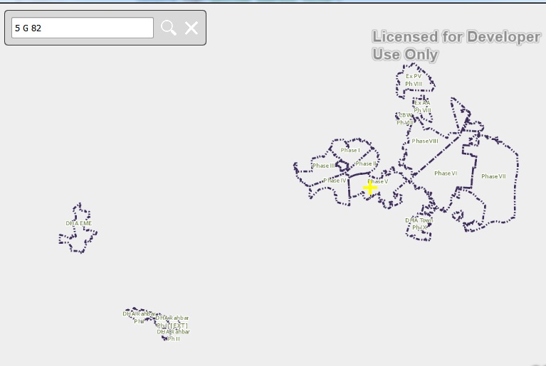
It would be greatly appreciated.
Cheers,
"Tasadduq Hussain"
- Mark as New
- Bookmark
- Subscribe
- Mute
- Subscribe to RSS Feed
- Permalink
- Report Inappropriate Content
That is expected as the single point geometry doesn't have an extent ( as min x,y and max x,y has same values). What you would have to do is to create a virtual extent around the point geometry and then zoom to that extent.
Another way is to create a buffer geometry (invisible- don't add it as graphic) around that point and then zoom to that buffer geometry.
Nakul
- Mark as New
- Bookmark
- Subscribe
- Mute
- Subscribe to RSS Feed
- Permalink
- Report Inappropriate Content
I am very Grateful Nakul Manocha.
I create Locator with Minimum Match/Candidate Score 100.
Now,it's working perfect and find only one address and also Zoom to that particular address.
Again I am very thankful to you.
Cheers,
"Tasadduq Hussain"