- Home
- :
- All Communities
- :
- Products
- :
- ArcGIS StoryMaps
- :
- Classic Esri Story Maps Questions
- :
- Exporting Story Map Tour table with long/lat data?
- Subscribe to RSS Feed
- Mark Topic as New
- Mark Topic as Read
- Float this Topic for Current User
- Bookmark
- Subscribe
- Mute
- Printer Friendly Page
Exporting Story Map Tour table with long/lat data?
- Mark as New
- Bookmark
- Subscribe
- Mute
- Subscribe to RSS Feed
- Permalink
- Report Inappropriate Content
Greets:
Is it possible to export the data from a Story Map Tour in a way that includes long/lat data?
I know I can export the table in ArcGIS desktop, but the long/lat data does not come with it.
Reason for asking; I want a way to sequentially renumber the points in a rather complicated web map application: https://asdm.maps.arcgis.com/apps/MapTour/index.html?appid=54b063f3cba845fb881c1f2d306e0664
Also, I think this would make a good back system for a story map.
Thank you,
Mark
- Mark as New
- Bookmark
- Subscribe
- Mute
- Subscribe to RSS Feed
- Permalink
- Report Inappropriate Content
Mark,
Have you brought the data into ArcGIS and added XY coordinates to it?
Adding x,y coordinate data as a layer—Help | ArcGIS for Desktop
(and if using Pro - Add XY Coordinates—Data Management toolbox | ArcGIS Desktop )
- Mark as New
- Bookmark
- Subscribe
- Mute
- Subscribe to RSS Feed
- Permalink
- Report Inappropriate Content
Adrian;
No, we are just placing points using the builder mode.
- Mark as New
- Bookmark
- Subscribe
- Mute
- Subscribe to RSS Feed
- Permalink
- Report Inappropriate Content
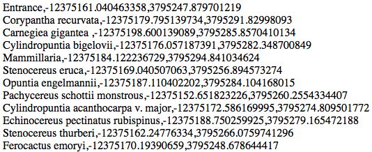
Maybe this will get you started. Your feature data can be accessed through the JavaScript function app.data.getAllFeatures(). It looks like your data are in Esri Web Mercator - if you need true lat/long, you'll have to do a little more work. Open the debugger tool in your browser and use a quick JS like:
var mylist = [];
var features = app.data.getAllFeatures();
for (var i=0;i<features.length;i++){
mylist.push([features[i].attributes.getName(),features[i].geometry.x, features[i].geometry.y]);
}
document.write(mylist.join("<br>"));Results in:
...
- Mark as New
- Bookmark
- Subscribe
- Mute
- Subscribe to RSS Feed
- Permalink
- Report Inappropriate Content
Thank you, Darren;
I'll give this a try
Mark