- Home
- :
- All Communities
- :
- Products
- :
- ArcGIS GeoPlanner
- :
- ArcGIS GeoPlanner Questions
- :
- Suitability Modeler is now part of Web AppBuilder
- Subscribe to RSS Feed
- Mark Topic as New
- Mark Topic as Read
- Float this Topic for Current User
- Bookmark
- Subscribe
- Mute
- Printer Friendly Page
Suitability Modeler is now part of Web AppBuilder
- Mark as New
- Bookmark
- Subscribe
- Mute
- Subscribe to RSS Feed
- Permalink
- Report Inappropriate Content
Imagine if, in a few clicks, you could answer multiple-factor spatial questions like Where are the areas on low angled slopes, in shrubby vegetation and are far from roads? What if you could do that and emphasize the importance of one of those factors over another?
You would be the hero of your workplace!
Questions like this are the essence of suitability modeling. Suitability modeling is a powerful analytical technique that enables you to find the best (or worst) places for a development or conservation activity, predict the likelihood of something occurring in an area, or find risks and opportunities in that area.
GeoPlanner, since its inception, has had a suitability modeling framework. That framework uses weighted raster overlay, on the web, to create models that can inform plans. Our intent was to enable anyone to use suitability modeling to make better decisions, solve tricky problems, and design a better future.
We decided recently that if we were serious about enabling anyone to use suitability modeling, we’d have to make it available to everyone through ArcGIS Online. We made it part of Web AppBuilder for its June 2017 update.
What can you do with it?
Suitability modeling on the web enables you to share your services and models with others and let them experiment with your ideas. This lets others get involved with your geospatial practice of planning, conservation, environmental screening and more. As a business partner once indicated, we wanted to let the public view possible outcomes that we had envisioned with a suitability model.
The Suitability Modeler widget in Web AppBuilder will let you engage your constituents by allowing them to view and change a model. You can share an app that uses this widget to the public so people can access your models without signing in. Without signing in, they can change and rerun your models. If they sign in, they can change, rerun and save a new version of your model as an item to an ArcGIS Online Organization.
Allowing stakeholders, constituents, decision makers, clients and others view and interact with your models will help them understand your thinking and help you build consensus for your ideas.
Get Started
It’s easy to start working with this widget. Here’s how:
- Sign in to ArcGIS Online and create a web map. You don’t even need to add layers to the map.
Save the map and click Share.
Click Create a Web App.
Click Web AppBuilder, type in an interesting name, and click Get Started.
Click a theme (like Billboard) and click on the Widget icon at the top of your browser.
- Click one of the grey Widget icons and then click on the Suitability Modeler icon (hint: it looks like 0 9). Click OK.
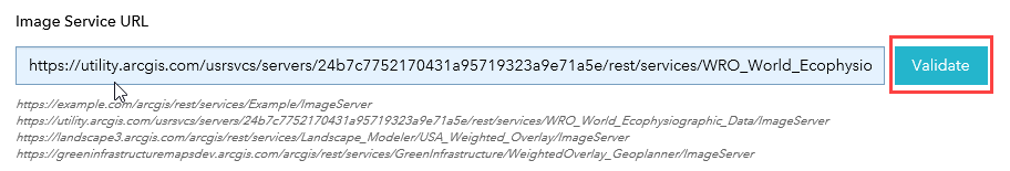
- In the Configure Suitability Modeler dialog, click the Validate button. This will make sure that you can access the World Ecophysiographic service hosted by Esri. Click OK.
- At the bottom left of the browser, click Save and then Launch. Your app will open in a new browser tab.
- Look for the 0 9 icon on the map. If you picked the Billboard theme, it will be in the upper left corner of the map. Click on it to open the Suitability Modeler widget.
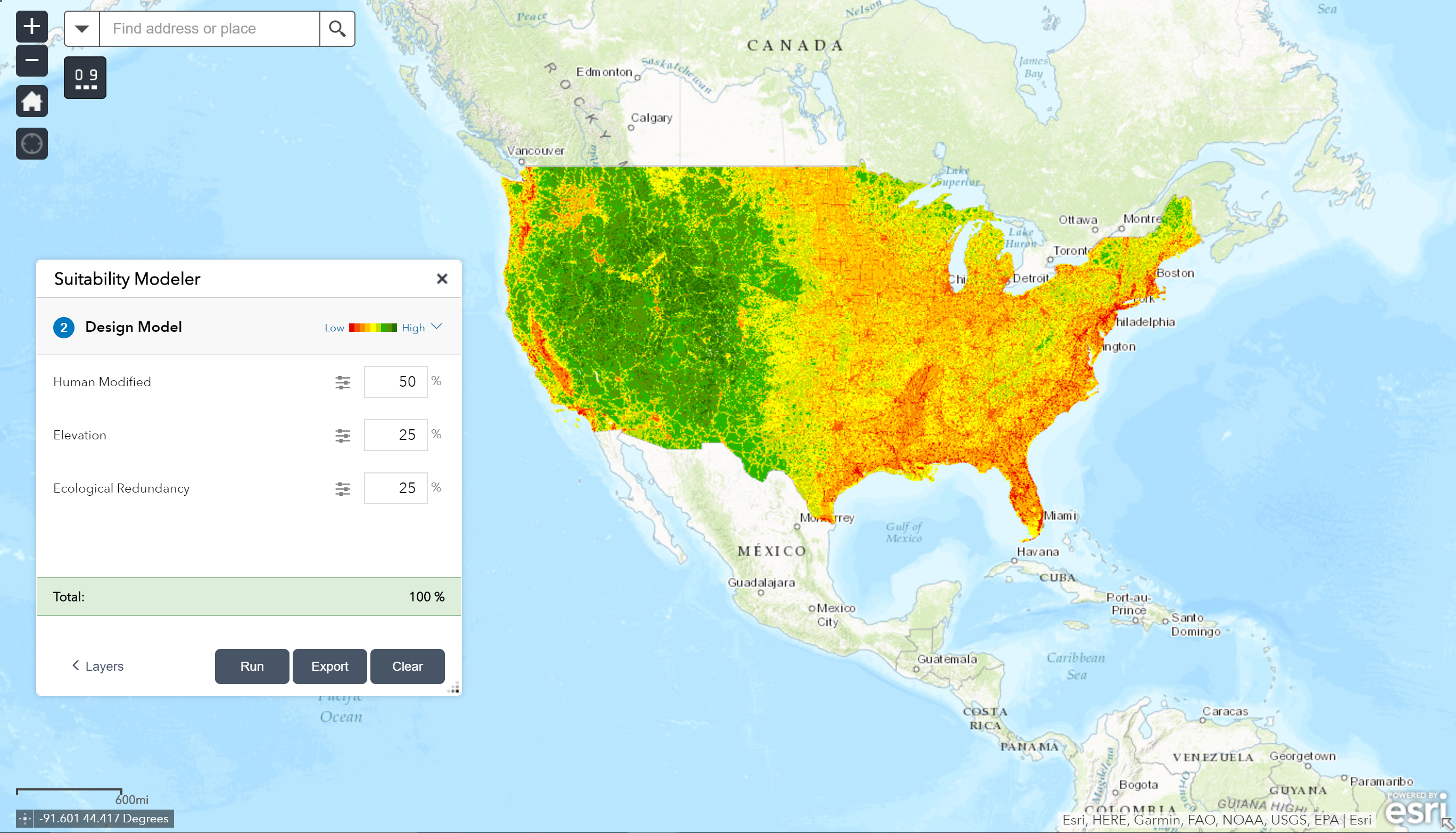
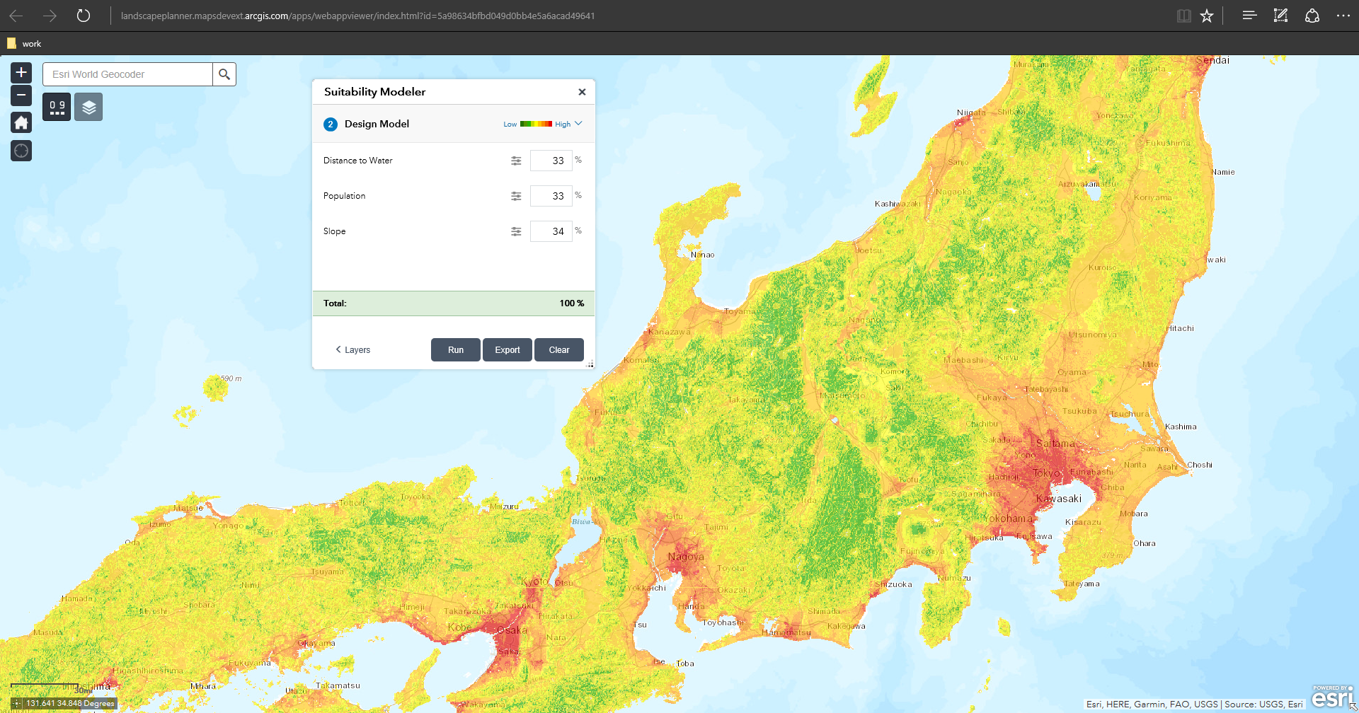
- In the Select Layers list, check on Distance to Water and Population.
Click Design Model to move to the Design Model screen.
- In this screen, you type in percentages for each layer. This allows you specify an importance for each layer in the analysis.
- Type in 50% for both layers. If you want, click the slider icons to examine and adjust the class values for each layer.
Click Run.
You’ve just created a model of population and distance to water! Shades of red represent high densities of people close to bodies of water like oceans, lakes and rivers. Shades of green represent lower densities of people living far from water bodies. Zoom to Tokyo and you’ll get a vivid picture of what this model communicates.
By the way, this process creates no intermediate datasets. It does not consume credits. The modeling operation is done in the request to and response from the ArcGIS Cloud so it’s fast!
Experiment by adding more layers, changing weights, and adjusting classification values for each layer. Adjusting a classification value within a layer allows you to emphasize or deemphasize those values in your model.
Alternatively, return to the configuration form and try one of the other two services. The USA_Weighted_Overlay service has 24 layers representing landscape variables for the United States. The Green Infrastructure service has 10 layers to help you evaluate landscape characteristics in the United States that are valuable for preservation.
Use your data
Modeling on the web helps you bring geospatial analysis to nearly anyone. We frequently hear that clients want to build models with their own data or data more local in scale.
You can do this if you have the right infrastructure. This includes:
- ArcGIS Enterprise 10.5x with Image Server
- ArcGIS Pro or Desktop
Learn more about building your own suitability modeling service by reviewing this topic. Building one of these services can bring a lot of value to your organization. Esri can help you prototype it by building and hosting the service for you so you can test its value yourself. If you’re interested, contact Esri Professional Services or reply to this post.
Learn more
I’m going to present on suitability modeling with GeoPlanner and Web AppBuilder at the 2017 Esri UC in San Diego. If you’re planning on attending our user conference, please attend one of my sessions at the following dates and times:
- Tuesday, July 11, 5:00 pm – 5:30 pm, SDCC – Tech Theater 18 Exhibit Hall A
- Wednesday, July 12, 10:00 am – 10:30 am, SDCC – Tech Theater 19 Exhibit Hall
Here’s another post that details GeoPlanner sessions at the UC.
Here’s some additional doc to help you understand Suitability Modeling in GeoPlanner and Web AppBuilder.
Final Words
We think that web based suitability modeling is super cool. We also think that you are going to realize how powerful and valuable it could be to your organization. You will probably realize that it’s another way you can engage your constituents. It’s fast, consumes no credits and can be run without an ArcGIS Online credential. It’s a great way to bring the science of where to everyone.
- Mark as New
- Bookmark
- Subscribe
- Mute
- Subscribe to RSS Feed
- Permalink
- Report Inappropriate Content
I am trying to utilize the suitability model widget with layers we host on our image server through our enterprise. Is this capability included with our Advanced Enterprise? Do I need to purchase Geoplanner?