- Home
- :
- All Communities
- :
- User Groups
- :
- Coordinate Reference Systems
- :
- Questions
- :
- ArcMap shapefiles are not overlaying even with the...
- Subscribe to RSS Feed
- Mark Topic as New
- Mark Topic as Read
- Float this Topic for Current User
- Bookmark
- Subscribe
- Mute
- Printer Friendly Page
ArcMap shapefiles are not overlaying even with the same coordinate systems.
- Mark as New
- Bookmark
- Subscribe
- Mute
- Subscribe to RSS Feed
- Permalink
- Report Inappropriate Content
Hi, everyone! So I'm fairly new to using ArcMap and have only taken one introductory level course using this system. I know the basics but can still get very confused. If this happens to be an easy fix then silly me, but I'm still learning!
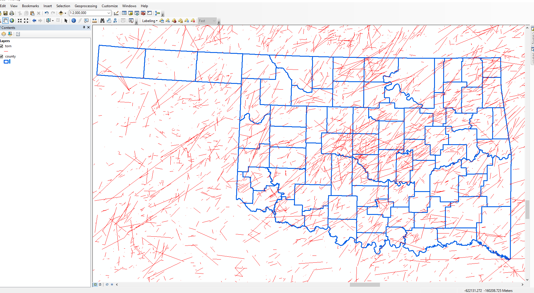
Anyway, when I upload two shapefiles to ArcMap they are not overlapping. I have to click "Zoom to Layer" to see each one. I know I have to change the coordinate systems but I am unsure how... If anyone would like to see the data I am using, I am using an Oklahoma Counties Shapefile and the Tornado Shapefile provided by NOAA. The links to each are provided below:
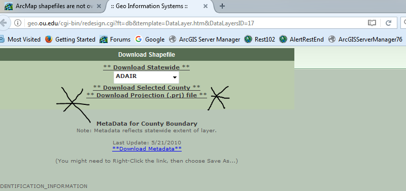
This is the link to the Oklahoma Counties shapefile. I downloaded the county shapefile for the entire state!
This is the link to the tornado shapefile provided by NOAA. I downloaded the torn.zip that you will see halfway down the page. It is the first of the three listed!
How do I get these two shapefiles to overlap? I have spent hours trying to figure this and have been reading/searching other posts but but I am not getting anywhere. Any help that can be provided would be great!
Solved! Go to Solution.
Accepted Solutions
- Mark as New
- Bookmark
- Subscribe
- Mute
- Subscribe to RSS Feed
- Permalink
- Report Inappropriate Content
I downloaded the two data sets you linked and they overlay fine. For the Oklahoma Counties Shapefile you need to download a separate .prj file for some reason (not really sure why they did it this way) and make sure you copy it to the same location as the other files that make up the shapefile (.shp, .dbf, etc.).
- Mark as New
- Bookmark
- Subscribe
- Mute
- Subscribe to RSS Feed
- Permalink
- Report Inappropriate Content
I know I have to change the coordinate systems but I am unsure how
To change coordinate system for layer use project tool. make them same.
Try to import the output coordinate system from the other shape file .To make sure they will be same.
- Mark as New
- Bookmark
- Subscribe
- Mute
- Subscribe to RSS Feed
- Permalink
- Report Inappropriate Content
I downloaded the two data sets you linked and they overlay fine. For the Oklahoma Counties Shapefile you need to download a separate .prj file for some reason (not really sure why they did it this way) and make sure you copy it to the same location as the other files that make up the shapefile (.shp, .dbf, etc.).
- Mark as New
- Bookmark
- Subscribe
- Mute
- Subscribe to RSS Feed
- Permalink
- Report Inappropriate Content
Hi, Christopher.
Thank you so much! I copied the prj file to the OK County folder and it worked perfectly. Maybe one day I'll learn all the ins and outs of ArcMap, but thank you so much for your response and added pictures!
- Mark as New
- Bookmark
- Subscribe
- Mute
- Subscribe to RSS Feed
- Permalink
- Report Inappropriate Content
Did you download the .prj file for the Oklahoma data? I just downloaded the state wide data and the .prj was not included. In ArcGIS you can add two or more feature classes of disparate projections and it will 'project on on the fly'.
Do this: add both the state data and noaa data to an ArcMap session. Use the full extent button (little globe looking button) and I bet things disaopear from view. That's because ArcMap is confused as to how it is supposed to 'project' 3-d data (remember, we live on this 3-d spheroid, floating in space) to a 2-d screen.
Make sense?
ETA: Looks like Christopher beat me to it....
- Mark as New
- Bookmark
- Subscribe
- Mute
- Subscribe to RSS Feed
- Permalink
- Report Inappropriate Content
You guys are great!! I copied the prj file into the county file and it worked!
Slowly but surely figuring out how ArcMap works... lol. Thanks for helping me and bearing with me 
- Mark as New
- Bookmark
- Subscribe
- Mute
- Subscribe to RSS Feed
- Permalink
- Report Inappropriate Content
Victoria Johnson - here is a link that you might take a look at about projections:
FAQ: Projection Basics: What the GIS professional needs to know
Also, if you can find a copy of 'Map Projections Georeferencing Spatial Data' which was written by MKennedy-esristaff, read it cover to cover. I consider it the Gospel of projections; my copy is tattered and dog eared. There is also 'Understanding Map Projections' by Melita and Steve Kopp; another keeper...
- Mark as New
- Bookmark
- Subscribe
- Mute
- Subscribe to RSS Feed
- Permalink
- Report Inappropriate Content
Joe,
Did you mean Margaret Maher's book: Lining up Data in ArcGIS?
Oh, the book you're referring to is one used as part of the ArcGIS Workstation documentation (version 8). Almost all the information is in the online documentation of ArcGIS Desktop.
Melita
- Mark as New
- Bookmark
- Subscribe
- Mute
- Subscribe to RSS Feed
- Permalink
- Report Inappropriate Content
....the book you're referring to is one used as part of the ArcGIS Workstation documentation (version 8)....
Call me old fashioned but sometimes the classics are just tough to beat! (Remember I cut my teeth on a Unix box and ArcInfo.) Seems like the web references you mention have the same graphics, and I've poached (errr, I mean downloaded) them for power point presentations for teaching.