- Home
- :
- All Communities
- :
- Products
- :
- Imagery and Remote Sensing
- :
- Imagery Questions
- :
- Help calculating four corner frame w/ FMV
- Subscribe to RSS Feed
- Mark Topic as New
- Mark Topic as Read
- Float this Topic for Current User
- Bookmark
- Subscribe
- Mute
- Printer Friendly Page
Help calculating four corner frame w/ FMV
- Mark as New
- Bookmark
- Subscribe
- Mute
- Subscribe to RSS Feed
- Permalink
- Report Inappropriate Content
Hi all,
I am running ArcMap 10.4.1 on a 64-bit windows machine. We have an infrared video with accompanying metadata collected in the field (w/ at least 12 of basic parameters) via GPS puck and inclinometer. We want to fully utilize full motion video and calculate the video footprint comprising of the four corner coordinates. When trying to multiplex the .csv and .mp4 video file together, Arc is able to generate a success report, but in fact fails, as the output video is 0 kb. I am thinking there must be something off in the values with the accompanying metadata sheet. It should be noted that the video is captured moving horizontally (parallel to ground), while mounted to a stand in the bed of a truck. I also attempted to calculate the vertical field of view, as I only had horizontal. I have attached the .csv metadata sheet if anyone is able to look at it and give advice/info/critique. I am also willing to send/attach the FLIR video that goes with the metadata.
Thanks!
- Mark as New
- Bookmark
- Subscribe
- Mute
- Subscribe to RSS Feed
- Permalink
- Report Inappropriate Content
Mark
I haven't verified the rest of your data yet (will try to review) but your UNIX Timestamps are corrupted. All show the same value. If you edit in MS Excel, you have to ensure you reset the time field to "Number" before saving the *.csv, otherwise when it sees a long number, it automatically reformats to "Scientific".
Can you restore the original time values?
Cody B
- Mark as New
- Bookmark
- Subscribe
- Mute
- Subscribe to RSS Feed
- Permalink
- Report Inappropriate Content
Mark
Your platform roll values of -88 degrees seem incorrect (and to be honest I'm not sure a platform roll value that large works properly - this has triggered some more testing for us). Were you intending to use that to apply a 90 degree rotation of the camera? If yes, I would apply that in the SensorRelativeRoll field
Try this file edited_csv
I know the roll and timestamp values are not correct in this file, but it should generate an output for you, with the 4 corners shown.
Cody B.
- Mark as New
- Bookmark
- Subscribe
- Mute
- Subscribe to RSS Feed
- Permalink
- Report Inappropriate Content
Hi Cody,
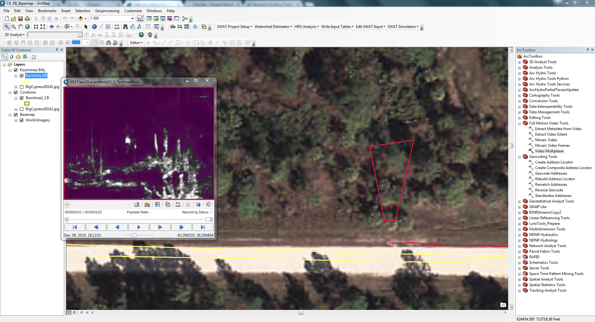
Wow! Thanks for your help. Using the csv you sent over, I corrected the timestamp and multiplexed the video and metadata together, and it worked perfectly. FMV was indeed able to calculate the 4 corner coordinates and visualize it real-time. This is exciting. I have attached the updated .csv in the original post if curious.
Thanks again for your assistance, and I won't hesitate to contact you all again if needed!
Mark
- Mark as New
- Bookmark
- Subscribe
- Mute
- Subscribe to RSS Feed
- Permalink
- Report Inappropriate Content
This does looks promising. Just picked up a Virb Ultra 30 for specifically loading video in to FMV. Attempts to capture vertical video with the Virb have yielded mixed results with heading/course not being very reliable. Corners are being calculated but often are not pointed in the correct direction. Additionally with the Virb Ultra 30 are there any in camera settings need to be considered as far as lens distortion / correction. The Virb has a couple digital in camera setting that crop the image and narrow the view to remove distortion. Its not clear if any adjustments would help or hurt footprints and or if they would get past along into the .csv.
*UPDATE* 8/30/17
Heading/Course issues with the Virb appear to be related to the magnetometer. The apparent solution: if in a vehicle is to perform a magnetometer manual calibration of the Virb before collection.
There isn't a built in calibration function on the Virb. Like cellphone compass calibrations, It appears that by simply manipulating the camera in a figure 8 motion while rotating its orientation for 10 or 15 seconds prior to collection will calibrate the Virb for its current environment.