- Home
- :
- All Communities
- :
- Industries
- :
- Water Resources
- :
- Water Resources Questions
- :
- Actual Versus Delineated stream network arc hydro ...
- Subscribe to RSS Feed
- Mark Topic as New
- Mark Topic as Read
- Float this Topic for Current User
- Bookmark
- Subscribe
- Mute
- Printer Friendly Page
Actual Versus Delineated stream network arc hydro then SWAT
- Mark as New
- Bookmark
- Subscribe
- Mute
- Subscribe to RSS Feed
- Permalink
- Report Inappropriate Content
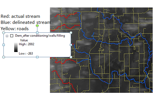
I was using arc Swat to delineate my watershed. arc swat produce streams network using DEM and my resultant streams were disconnected so I came across arc hydro tool to burn actual network in my DEM. I am using 10 m USGS dem. Probably not the best choice (for hydrologic modeling) but LIDAR <5 DEM is not available in my study area. I reconditioned my DEM (somehow DEM leveling did not work for me after trying several times. I got error in arc hydro). Reconditioning worked then I build walls and in the last I did filling.
Inner wall:- roads (all network, major minor)
Breach line- all stream network
I noticed that after using the resultant Dem, the flow paths for my network have improved, but my network is still disconnected at few locations. (see the images below please)
Changing stream buffer from 5 number of cells to 10 also did not make a difference. However I have not played around with smooth drop raise and sharp raise. I was using default values in arc hydro manual.
I also think that in my case there is not actually significant mismatch between actual and delineated streams but more like shorter length of delineates streams. The segments that dem missed to delineate are not only first order streams (that’s what I thought initially). Half of them are first order, remaining half ae higher order streams
Some other things I am planning to do based on suggestions from old posts:
- Take raw DEM, convert it form 10 m to 1 meter by (raster resampling) and then repeat Dem Reconditioning, Build walls and Filling. However I don’t think that I will make much difference
- Take DEM that I have already reconditioned, burn it again with stream segments where there is mismatch between my actual and delineated network. (but I think that I am overusing burning and forcing my streams to follow a certain path. Still there is a chance this method wont work where segments are disconnected)
- By browsing through answers in this community related to arc hydro, someone suggested using roads as buffers and then clip streams segments where roads intersect. I think arc hydo already does that during building wall process. So I don’t need to do that
- Just in case I separately clipped my streams using 5 meter road buffer outside of arc hydro in arc gis and I got some tiny dots as segments where stream is crossing a roads. Now if I zoom , does not look like the problem is because of road crossing.
- For some reasons I think that I should fill my raw dem first then DEM reconditioning and then building walls)
Any suggestions from experienced people would help me to improve my dem.