- Home
- :
- All Communities
- :
- Products
- :
- ArcGIS Pro
- :
- ArcGIS Pro Questions
- :
- Elevation Layer cutting through features
- Subscribe to RSS Feed
- Mark Topic as New
- Mark Topic as Read
- Float this Topic for Current User
- Bookmark
- Subscribe
- Mute
- Printer Friendly Page
Elevation Layer cutting through features
- Mark as New
- Bookmark
- Subscribe
- Mute
- Subscribe to RSS Feed
- Permalink
- Report Inappropriate Content
Hi All, i'm very new to Arc Pro (first time properly using it).
I'm overlaying some proposed design work on the default elevation surface. In places the elevation surface protrudes through the design features (see attachment). Is there a way to stop this from happening? Preferably without geoprocessing.
Essentially what we would like is the complete design work to be visible with the elevation surface filling in the surrounding environment.
Thanks in advance
- Mark as New
- Bookmark
- Subscribe
- Mute
- Subscribe to RSS Feed
- Permalink
- Report Inappropriate Content
You could define a relevant Cartographic Offset for the design feature.
Define height characteristics for layers—ArcGIS Pro | ArcGIS Desktop
Think Location
- Mark as New
- Bookmark
- Subscribe
- Mute
- Subscribe to RSS Feed
- Permalink
- Report Inappropriate Content
You could also put the features on the ground.
- Mark as New
- Bookmark
- Subscribe
- Mute
- Subscribe to RSS Feed
- Permalink
- Report Inappropriate Content
The features are 3D (have z values) so they are extruded and elevated above the surface. If we draped them they result would be displayed in the wrong location
- Mark as New
- Bookmark
- Subscribe
- Mute
- Subscribe to RSS Feed
- Permalink
- Report Inappropriate Content
I don't think that will work for us as it will offset them and they will be displayed in the incorrect location
- Mark as New
- Bookmark
- Subscribe
- Mute
- Subscribe to RSS Feed
- Permalink
- Report Inappropriate Content
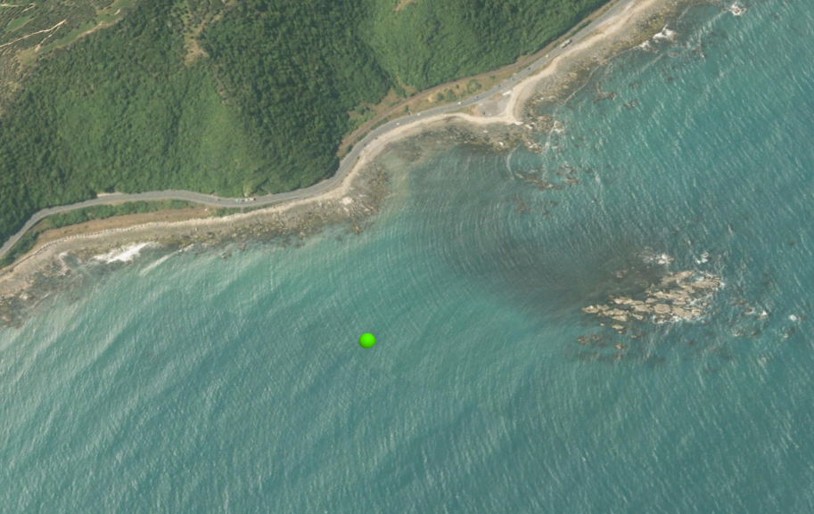
Hamish, taking a wild guess you are working on SH 1 a little north of Kaikoura, on the coast (i.e. sea level matters).
If your data has ellipsoidal heights (like from GPS) and you are using the default World DTM elevation surface, which is orthometric, then you should apply a cartographic offset equal to the geoid offset, or 12.68m around there.
I didn't pick the number out of thin air. See the attached too, included in the download, but edited for the locality lat-long.
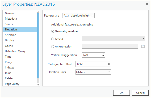
I added the shapefile created by the tool to a scene, applied a cartographic offset of 12.68m and the point sits exactly at sea level.
This is a whole lot easier than reprojecting your data vertically (which can be done too).
The layer elevation properties:
- Mark as New
- Bookmark
- Subscribe
- Mute
- Subscribe to RSS Feed
- Permalink
- Report Inappropriate Content
Hi Bruce, thanks for that - yes you picked the location perfectly.
Unfortunately I don't think that will do the trick either...
What we're trying to do is pull the design data through from 12D Synergy into our GIS system and display it in a Web Scene. This design data is updated daily. We're using FME to pull the data from 12D into a GDB. This is then going to be overlayed on a custom elevation surface (0.5m res).
The design data is true and therefore setting a cartographic offset is going to misrepresent the data. I have spoken with Todd Davis and we think the best solution will be to get FME, during the GDB update, to lower the sections of the DEM that overlap the design data. Then push the new data to arcgis server, and rebuild the elevation service cache with the new data.

I was hoping that we could specify in ArcPro to not draw the elevation service through features that are on top of it.
Cheers, Hamish
- Mark as New
- Bookmark
- Subscribe
- Mute
- Subscribe to RSS Feed
- Permalink
- Report Inappropriate Content
Well that covers off the problem being different vertical datums.
I asked around, this problem is called Z-fighting - some DEM points are higher than the construction features.
Someone suggested adding a zero-elevation (or lower anyway) source with shape taken from the roadway footprint. One option is to make a TIN from your construction elements. There may be interference artifacts at the base of the walls. If it looks bad go with burning the flat area into your DEM.