- Home
- :
- All Communities
- :
- User Groups
- :
- Cartography and Maps
- :
- Questions
- :
- How to Space / Explode / Separate Shape files?
- Subscribe to RSS Feed
- Mark Topic as New
- Mark Topic as Read
- Float this Topic for Current User
- Bookmark
- Subscribe
- Mute
- Printer Friendly Page
How to Space / Explode / Separate Shape files?
- Mark as New
- Bookmark
- Subscribe
- Mute
- Subscribe to RSS Feed
- Permalink
- Report Inappropriate Content
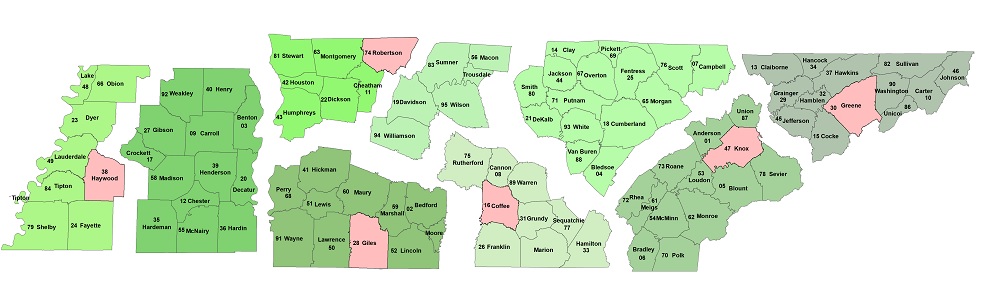
I know that title sounds strange but I don't know exactly how to word what I'm wanting to do. I'm currently making a territory map of Tennessee with certain areas of Tennessee divided into districts. I attached an example of the map I'm working on. For me to create this map I had to select the counties in each district and export them into their own shape file, and then edit the district and move it out to space it. I'm just trying to put a little distance in between the districts instead of just changing the symbol to reflect the change. Currently I'm exporting each district into it's own TIFF file and then using Photoshop to put the distance in each district, but i figured there was a way to do this in layout mode without all the hassle of using Photoshop, but that may be asking to much. So is it possible to do this in ArcGIS Desktop 10.2?
Thanks!
Solved! Go to Solution.
Accepted Solutions
- Mark as New
- Bookmark
- Subscribe
- Mute
- Subscribe to RSS Feed
- Permalink
- Report Inappropriate Content
Yeah that's what I've ended up doing. I make a copy of the state wide shape file. i go into the attribute table where I have a column for districts. I then select by attribute for the district and then I go in and manually move them away from the rest. After I get the spacing correct I display the symbology, logos, legend, and labels I want present and then export it. After that if there's anything that needs to be touched up I use Photoshop, but I try to keep it all within ArcGIS so i don't have to go back in every time and edit the TIFF file in Photoshop. I was just hoping there was a way to do this within ArcGIS encase my districts ever change. In that case I will have to go in and change the attribute information and also move each county manually to the correct district. It would just be a lot easier if there was a type of symbology that could space districts (features) out by attributes.
- Mark as New
- Bookmark
- Subscribe
- Mute
- Subscribe to RSS Feed
- Permalink
- Report Inappropriate Content
A lot of state DOTs show a format similar to your example, for viewing and printing their state transportation map in (smaller file size) sections from their official website. If you export your map to any "vector" format, then use Adobe Illustrator to separate the regions, you should have good luck. . . You are right. There are a lot of ways to accomplish this. If you do go a different route and are pleased with it, please share!
- Mark as New
- Bookmark
- Subscribe
- Mute
- Subscribe to RSS Feed
- Permalink
- Report Inappropriate Content
This method would still mean creating separate datafiles for each region.
A possible way to do this is to modify the coordinate systems for each region if they're using a projected coordinate system. You could adjust the false easting and/or the false northing parameter values to "move" the data from its normal location. You would use the Define Projection tool, or the data's property page, NOT the Project tool.
Melita
- Mark as New
- Bookmark
- Subscribe
- Mute
- Subscribe to RSS Feed
- Permalink
- Report Inappropriate Content
It sounds like the method I'm using now is the best. I just thought there may have been a way to accomplish this in the layout view for presentation or something. I went through a modified a shape file of counties and selected by region and spaced them out by hand. I know this completely eliminates the whole Idea behind GIS and having data in the proper location, but the data layers don't change often, just the data in the attribute tables changes from time to time. I mainly need to display information within each county like county codes, county names, employees who cover those areas, so at this time this will be good.
Thanks for all the help, if anyone thinks of another way just let me know.
- Mark as New
- Bookmark
- Subscribe
- Mute
- Subscribe to RSS Feed
- Permalink
- Report Inappropriate Content
get a copy!! into edit mode, select groups of polygons the drag them to where you want them you can play around with where you want them and you will have a template... No big deal that they are displaced they are used in isolation from other data I presume
- Mark as New
- Bookmark
- Subscribe
- Mute
- Subscribe to RSS Feed
- Permalink
- Report Inappropriate Content
Yeah that's what I've ended up doing. I make a copy of the state wide shape file. i go into the attribute table where I have a column for districts. I then select by attribute for the district and then I go in and manually move them away from the rest. After I get the spacing correct I display the symbology, logos, legend, and labels I want present and then export it. After that if there's anything that needs to be touched up I use Photoshop, but I try to keep it all within ArcGIS so i don't have to go back in every time and edit the TIFF file in Photoshop. I was just hoping there was a way to do this within ArcGIS encase my districts ever change. In that case I will have to go in and change the attribute information and also move each county manually to the correct district. It would just be a lot easier if there was a type of symbology that could space districts (features) out by attributes.
- Mark as New
- Bookmark
- Subscribe
- Mute
- Subscribe to RSS Feed
- Permalink
- Report Inappropriate Content
to computationally group, explode and shift geometry objects, requires potentially complex rules which requires a lot of programming. Yours is the first request that I have seen on this topic, so I suspect the market is small for what you want to do, hence no script... on the other hand, should you want to distort space by attributes... do a search on 'Cartograms' which is a whole different way to view attributes and their geometric relationships.