- Home
- :
- All Communities
- :
- User Groups
- :
- Coordinate Reference Systems
- :
- Questions
- :
- Which projected coordinate system?
- Subscribe to RSS Feed
- Mark Topic as New
- Mark Topic as Read
- Float this Topic for Current User
- Bookmark
- Subscribe
- Mute
- Printer Friendly Page
Which projected coordinate system?
- Mark as New
- Bookmark
- Subscribe
- Mute
- Subscribe to RSS Feed
- Permalink
- Report Inappropriate Content
I am currently trying to establish the proper Projected Coordinate System for features that span Washington, Oregon, and California. I wish to preserve area and length if possible. I thought that UTM zone 10 may not cause too much distortion in the southern/eastern end of the states. Any suggestions for optimal projections would be super helpful!
- Mark as New
- Bookmark
- Subscribe
- Mute
- Subscribe to RSS Feed
- Permalink
- Report Inappropriate Content
If they fit into a UTM zone, then that should be fine.
UTM is conformal, but I would weigh the potential 'error' (4ish parts in 10,000) to the actual error of the data you have. Plus your extent is longer than wide, which suits a UTM.
Everyone will have some suggestions, so short of an equal area/equidistance projection, (that no one else really routinely uses) UTM would be a good one.
- Mark as New
- Bookmark
- Subscribe
- Mute
- Subscribe to RSS Feed
- Permalink
- Report Inappropriate Content
That extent is smack in the middle of zones 10 and 11. UTM uses transverse Mercator which maintains shapes (angles), not areas nor distances. It's impossible to maintain all distances. Normally you get all distances from the center point, or along all longitude lines plus any standard parallels.
Depending on which version you have, there are tools or arcpy functions which can return "geodetic"-based areas and distances. Here's a link to a blog post discussing the calculation of the geodesic-based areas in the field calculator.
If you want the data stored in a equal area projection, you could design your own. Albers is a conic projection or cylindrical equal area would work.
If you want to stick with transverse Mercator, I would do a custom one with the central meridian at -117. If you leave the scale factor at 1.0, the central meridian will have no distortion. Otherwise, adding a scale factor, like 0.9996, will move the no-distortion lines out away from the central meridian. UTM zones were designed to be no worse than 1:2500 (which occurs along the central meridian and the zone edges).
Melita
- Mark as New
- Bookmark
- Subscribe
- Mute
- Subscribe to RSS Feed
- Permalink
- Report Inappropriate Content
Thank you guys for the responses. I would like to stick with the standard UTM Zone 10 which fits most of the features inside, only a small portion of the features reside in zone 11. If the error that is produced is not minimal, then I would be willing to create a custom one with the central meridian at -117.
Thanks!
- Mark as New
- Bookmark
- Subscribe
- Mute
- Subscribe to RSS Feed
- Permalink
- Report Inappropriate Content
Some general comments/visual:
If your data includes whole states, using only UTM 10 may be a bit problematic as Caliornia is split between UTM 10 and 11 pretty equally.
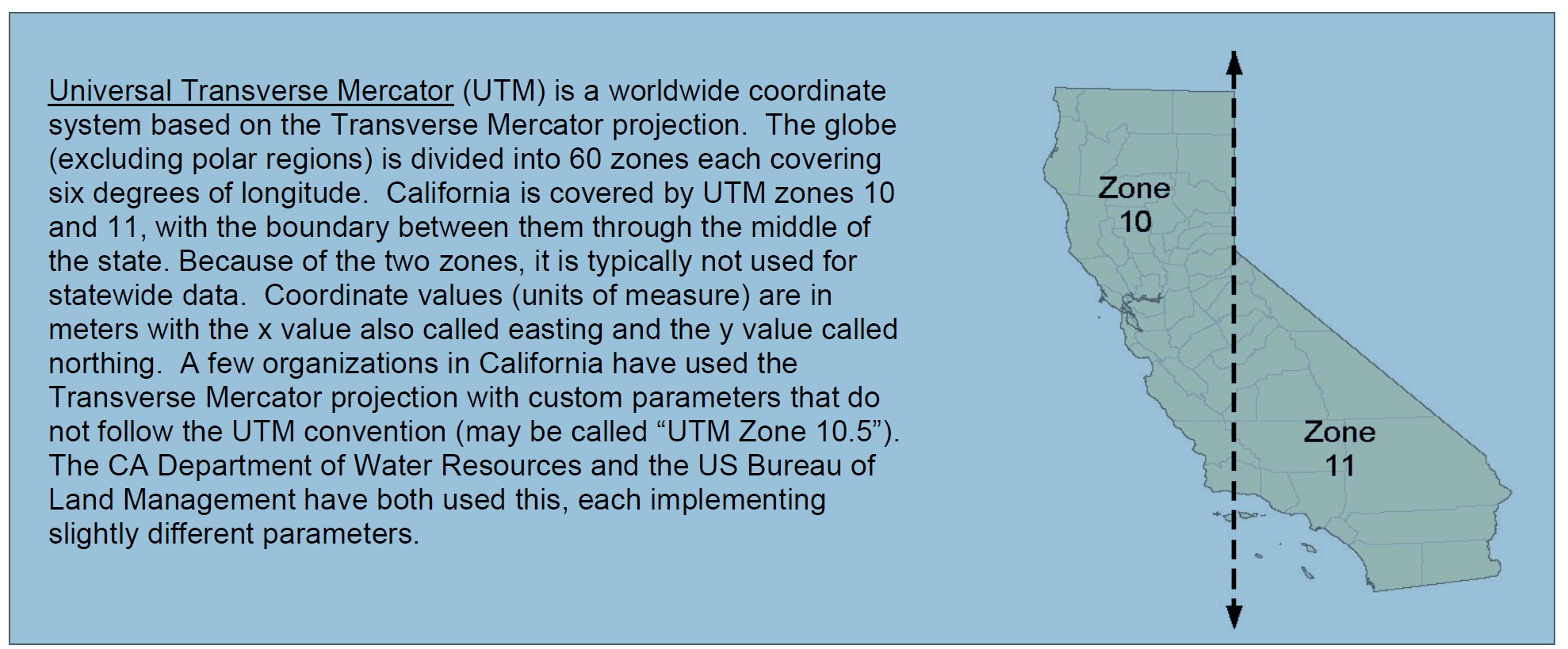
Source: https://www.google.com/search?q=Teale+Albers&ie=utf-8&oe=utf-8
The common solution at the California state level is to use the Teale Albers projections. Also, as mentioned in the picture above, some folks use a custom "UTM 10.5".
http://spatialreference.org/ref/sr-org/california-teale-albers-nad27-projection/prettywkt/
http://spatialreference.org/ref/sr-org/10/prettywkt/
I'd consider what Melita Kennedy suggested.
Chris Donohue, GISP