Turn on suggestions
Auto-suggest helps you quickly narrow down your search results by suggesting possible matches as you type.
Cancel
- Home
- :
- All Communities
- :
- Products
- :
- 3D
- :
- 3D Questions
- :
- How to process .XYZ format data
Options
- Subscribe to RSS Feed
- Mark Topic as New
- Mark Topic as Read
- Float this Topic for Current User
- Bookmark
- Subscribe
- Mute
- Printer Friendly Page
How to process .XYZ format data
Subscribe
19917
12
12-08-2011 05:20 AM
12-08-2011
05:20 AM
- Mark as New
- Bookmark
- Subscribe
- Mute
- Subscribe to RSS Feed
- Permalink
- Report Inappropriate Content
Hi everyone,
I'm an undergraduate student, need help for my final year thesis. I have a LIDAR data which is in .XYZ format. How can I process the data to generate a raster files? I have tried using ASCII 3D to Feature Class tool under 3D Analyst/Conversion toolset in ArcCatalog, however, the .shp files generated is problematic. The points do not have height information, hence, I cannot proceed to generate TIN. I do not understand why the software cannot read the Z information from the .XYZ files. Is there any other way to create raster files from the .XYZ files? Really need help..(Note : I'm using ArcGIS 9.3 and the .XYZ files using TAB separator)
Thank you
12 Replies
12-08-2011
06:36 AM
- Mark as New
- Bookmark
- Subscribe
- Mute
- Subscribe to RSS Feed
- Permalink
- Report Inappropriate Content
Could you attach a sample of your lidar data (for download) that includes the column headers and a few hundred rows? It would be easier to troubleshoot if we can look at a sample of the xyz data you're trying to work with.
12-11-2011
05:07 AM
- Mark as New
- Bookmark
- Subscribe
- Mute
- Subscribe to RSS Feed
- Permalink
- Report Inappropriate Content
12-13-2011
03:17 PM
- Mark as New
- Bookmark
- Subscribe
- Mute
- Subscribe to RSS Feed
- Permalink
- Report Inappropriate Content
The output of the 'ASCII 3D to Feture' tool (Output Feature Class Type: POINT) is a 3D feature class and contains Z information. Run the Add XY Coordinates tool (Data Management Tools > Features) and the Z values will be added into the attribute table.
12-14-2011
03:30 AM
- Mark as New
- Bookmark
- Subscribe
- Mute
- Subscribe to RSS Feed
- Permalink
- Report Inappropriate Content
Thanks for the advice! 🙂 I've tried the 'Add XY Data' using sample data (the one that I've simplified) which contains only 1048576 points instead of using the full data and yes, it works..! I can proceed to generate TIN and also raster files.
However, when I tried using the full data which contain 51424541 points, TIN cannot be generated. Is it because of the file size..?
However, when I tried using the full data which contain 51424541 points, TIN cannot be generated. Is it because of the file size..?
12-14-2011
06:13 AM
- Mark as New
- Bookmark
- Subscribe
- Mute
- Subscribe to RSS Feed
- Permalink
- Report Inappropriate Content
I would recommend you to create a terrain instead of TIN as there is a limitation on number of nodes with TINs. Once a terrain is created, you can run Terrain to Raster tool to generate a raster surface.
From the help documentation:
The maximum allowable size of a TIN varies relative to free, contiguous, memory resources. 10 to 15 million nodes represents the largest size achievable under normal operating conditions with Win32. Regardless, it's strongly recommended to cap the size at a few million for the sake of usability and performance. Anything larger than this is best represented using a terrain dataset.
12-15-2011
09:04 PM
- Mark as New
- Bookmark
- Subscribe
- Mute
- Subscribe to RSS Feed
- Permalink
- Report Inappropriate Content
12-16-2011
03:20 PM
- Mark as New
- Bookmark
- Subscribe
- Mute
- Subscribe to RSS Feed
- Permalink
- Report Inappropriate Content
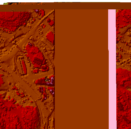
Can anyone explain to me why is the terrain generated only half...?
12-19-2011
06:03 AM
- Mark as New
- Bookmark
- Subscribe
- Mute
- Subscribe to RSS Feed
- Permalink
- Report Inappropriate Content
Did you already try re-creating the terrain?
12-20-2011
02:05 AM
- Mark as New
- Bookmark
- Subscribe
- Mute
- Subscribe to RSS Feed
- Permalink
- Report Inappropriate Content
vattarai,
Sorry for not updating my progress..yes, I did re-creating the terrain and it works...
terrain was successfully generated..
then, I created a raster files using 'Terrain to Raster' under 3D Analyst Tools in ArcToolbox..
however, the raster created looks so rough..Is it because of the 'Pyramid Level Resolution'..? because I've choose 2 for the Pyramid Level Resolution...what does it mean by 'Pyramid Level Resolution' and how it affect the raster file..?