Turn on suggestions
Auto-suggest helps you quickly narrow down your search results by suggesting possible matches as you type.
Cancel
- Home
- :
- All Communities
- :
- Products
- :
- ArcGIS Explorer Desktop (Retired)
- :
- ArcGIS Explorer Desktop Questions
- :
- georeferencing, tools greyed out
Options
- Subscribe to RSS Feed
- Mark Topic as New
- Mark Topic as Read
- Float this Topic for Current User
- Bookmark
- Subscribe
- Mute
- Printer Friendly Page
georeferencing, tools greyed out
Subscribe
8603
4
11-30-2011 08:59 AM
11-30-2011
08:59 AM
- Mark as New
- Bookmark
- Subscribe
- Mute
- Subscribe to RSS Feed
- Permalink
- Report Inappropriate Content
About 25% of the time, when I add an image for georeferencing, most of the tools are greyed out and I can't work (Fit To Display etc. see attachment). I don't have the image highlighted in ArcCatalog, I don't know what the issue is. Sometimes I have to reboot.
thanks in advance
thanks in advance
4 Replies
12-01-2011
05:02 AM
- Mark as New
- Bookmark
- Subscribe
- Mute
- Subscribe to RSS Feed
- Permalink
- Report Inappropriate Content
Nevermind. If your editing layer is rotated the tools are greyed out.
08-08-2017
01:21 PM
- Mark as New
- Bookmark
- Subscribe
- Mute
- Subscribe to RSS Feed
- Permalink
- Report Inappropriate Content
It works perfect for me.
My map was rotated 359º to see "right" a little section of map, but it didn't allow me to georeferencing images.
I went to Data Frame Properties -> General: and I change "rotations" 359 for 0 and tool began to be enabled.
Nice!
03-27-2014
10:58 AM
- Mark as New
- Bookmark
- Subscribe
- Mute
- Subscribe to RSS Feed
- Permalink
- Report Inappropriate Content
Or the data frame...
I had to check the Data Frame Properties>General tab> Rotation box.
This was set to 359 59 59 for some reason and I reset it to 0 to fix the problem.
I had to check the Data Frame Properties>General tab> Rotation box.
This was set to 359 59 59 for some reason and I reset it to 0 to fix the problem.
01-20-2017
05:30 AM
- Mark as New
- Bookmark
- Subscribe
- Mute
- Subscribe to RSS Feed
- Permalink
- Report Inappropriate Content
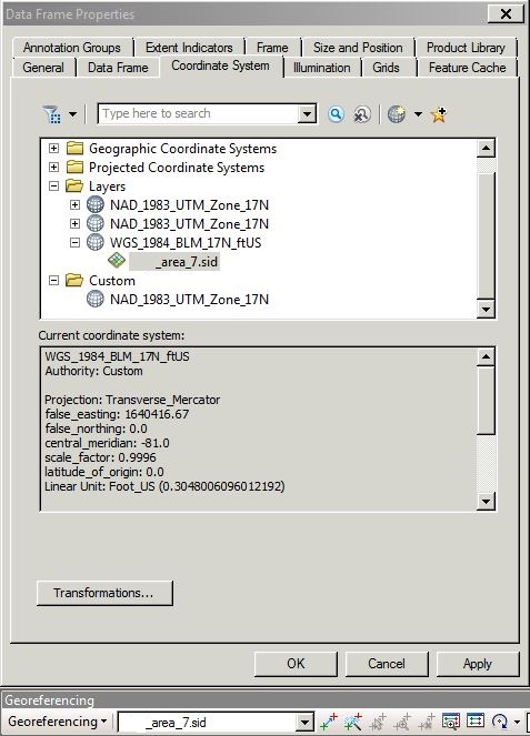
I've found a workaround. In the Data Frame Properties for the data frame that you need to georeference, go to Coordinate System. Expand layers, then the coordinate system assigned to your imagery, then click on the imagery layer that you want to georeference. It should change the Georeferencing toolbar from grayed out to active.