- Home
- :
- All Communities
- :
- Events
- :
- User Conference
- :
- User Conference Blog
- :
- UC 2017 Daily Updates Day Five (Friday): Closing S...
UC 2017 Daily Updates Day Five (Friday): Closing Session, Awards and Recap
- Subscribe to RSS Feed
- Mark as New
- Mark as Read
- Bookmark
- Subscribe
- Printer Friendly Page
- Report Inappropriate Content

Welcome to the fifth and final day of UC coverage on Geonet! It's been an amazing week of connecting and collaborating with you all in San Diego and in the community. The last day wrapped with the closing session featuring the Map and GeoNet awards, Jack's closing remarks and the Open Q&A session. Here are some of the highlights and links to all the UC GeoNet coverage. Enjoy!
Note: If you missed any of the GeoNet coverage, check out the list below:
- https://community.esri.com/community/events/user-conference/blog/2017/07/10/live-blog-2017-esri-uc-p...
- https://community.esri.com/community/events/user-conference/blog/2017/07/10/live-blog-2017-esri-uc-p...
- https://community.esri.com/community/events/user-conference/blog/2017/07/12/uc-2017-daily-updates-da...
- https://community.esri.com/community/events/user-conference/blog/2017/07/13/uc-2017-daily-updates-da...
- https://community.esri.com/community/events/user-conference/blog/2017/07/14/uc-2017-daily-updates-da...
Closing Session Segments (click to jump to segment)
UC 2017 Map Award Winners
The following is a list of the winners for this year's Map Awards. Congrats to the winners and thanks to all who submitted your work this year!
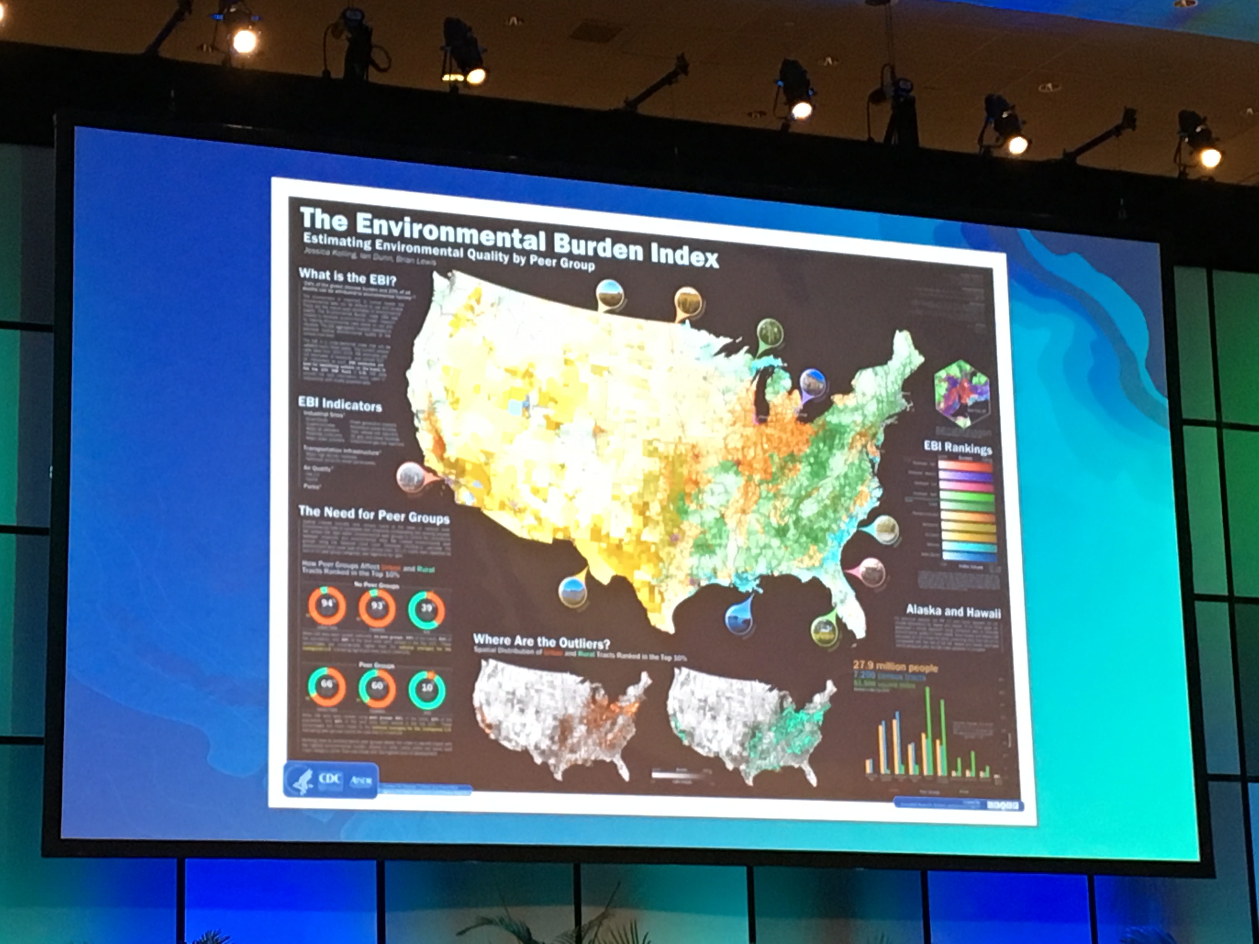
- Best of Show: The Environmental Burden Index: Estimating Environmental Quality by Peer Group
- Jessica Kolling, Ian Dunn, Brian Lewis; Centers for Disease Control and Prevention
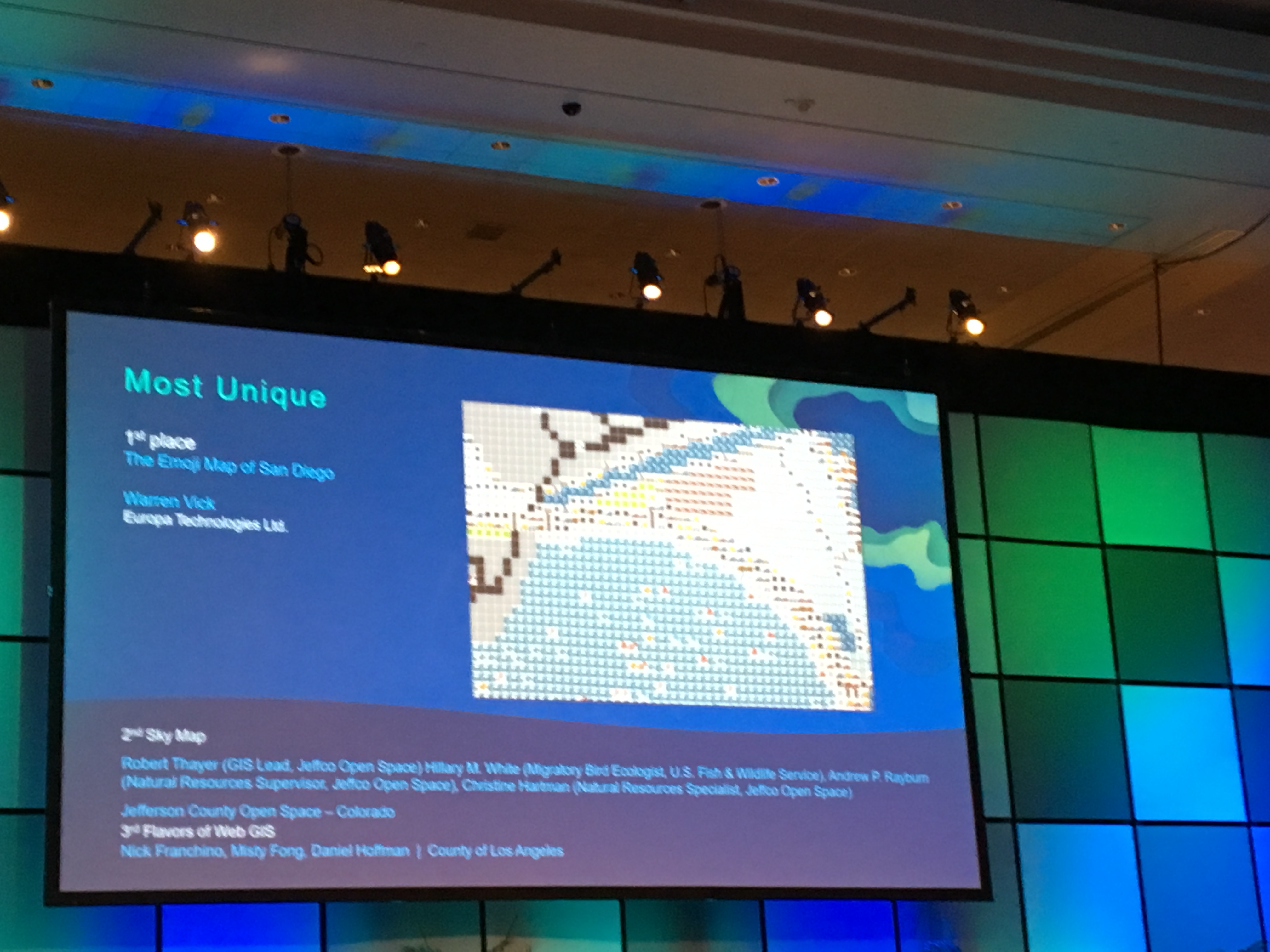
- Most Unique - The Emoji Map of San Diego
- Warren Vick; Europa Technologies Ltd.
- Best Map Series of Atlas - Atlas of Conversation Opportunities in the Amazon Bione Under Climate Change Considerations
- Johanna Prassmann, Ceasar Suajrez and Maria Elfi Chaves; WWF Colombia
- Best Use of an API in a Map - FlowsMapper Poster
- Prepared by the Geography Division, Population Division, and Social, Economic and Housing Statistics Divison, U.S. Census Bureau
- Best Story Map: Remember the Alamo in 3D
- Michael A. Garza, GISP; Pape-Dawson Engineers
- Best ArcGIS Pro Map: The Union Canal (Fallkirk to Edinburgh)
- Doug Cain; City of Fort Collins
- Best Large Format Printed Map: A Perspective View of Gallatin County, Montana
- Frank L Dougher; Gallatin County
- Best Analytic Map: Modeling the Prehistoric Extent of San Francisco Bay and Potential for Cultural Resources
- Paul Brandy and Shannon DeArmond; Far Western
- Best Cartography Special Interest Group Map:
- Santiam Pass Winter Recreation, Willamette and Deschutes National Forest; USDA Forest Service
USDA Forest Service, Pacific Northwest Region Cartography Unit
- North American Natural Gas; S&P Global Platts
Ginny Mason
- Alley Pond Park; NYC Parks
Ben Perry Blackshear
- Santiam Pass Winter Recreation, Willamette and Deschutes National Forest; USDA Forest Service
- Best Instructional Map: Data Driven Pages to the Rescue
- Corey Bowens, Michael Campbell, Bob Carberry, Paul Clement; St. Johns County
- ICA Winners:
- Geologic Map of Great Sand Dunes National Park, Colorado
- Paco VanSistine, Richard Madole, Joseph Romig; U.S. Geological Survey
Relationship between geographical names and landforms with names of birds in Japan
Masataka Satoh
- Geologic Map of Great Sand Dunes National Park, Colorado
- Best of User Apps Fair: Exotic Plant Information Collector (EPIC)
- Best Student Map up to age 12: Colored Community Map
- Tri-County Preschool Class; Pro-West & Associates
- Best Student Map ages 13-18: Geospatial Analysis of the Distribution of Sea Turtles and Sharks off the Coast of Long Island, New York
- Sohum Sheth; Stony Brook University
- Best Student Map - post-secondary, university, and postgrad: Pinpointing Vulnerabilities - Protecting Regions of the Arctic
- Gabriel Rousseau and Kyle Lempinen; Bureau of Land Management, Oregon State Office
GeoNet Awards: 2016 Top Contributors
Earlier this year we recognized the top GeoNet contributors Robert Scheitlin, GISP, Dan Patterson and Rebecca Strauch, GISP and it was exciting to give them a well-earned shout out at UC too.
UC Facts and Stats
- 17,980 attendees
- 2,000 Esri Staff
- 136 countries
- 326 Exhibitors
- 400+ students
- A special shout-out to the Student Assistant program. This program plays a crucial role throughout UC and in starting and further GIS careers after the event. You can get involved and learn more about it here.
- 900+ Young Professionals
- 37 Plenary speakers
- 314 Technical workshops
- 133 Special Interest Groups
- 407 Demo Theaters
- 290 Paper Sessions
- 900 Maps (Map Gallery)
- 703 runners (Esri 5K)
- 90,950 buttons (Did you get your first-edition UC GeoNet button?)
- Many Lifelong learners!
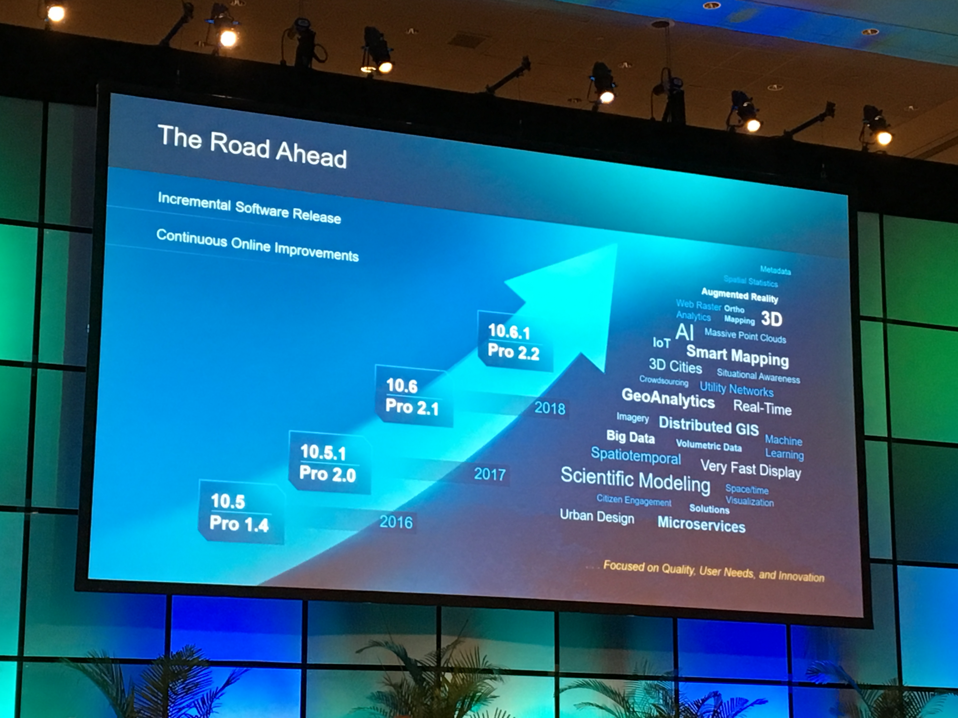
The Road Ahead
Jack's UC 2017 farewell, "Thank you and I love you. See you next year!
Thanks so much for following along! And a big thanks to all the guest contributors (Rachel Weeden, Dawn Wright, Joseph Kerski, Suzanne Boden, Adrian Welsh, Amy Niessen and many others) who shared their experiences with us throughout the week. It was great to partner with you this year and expand the coverage and perspective of UC 2017.
We hope you enjoyed UC 2017! We look forward to hearing what you're learned and what your biggest takeaways were from this year's event. Let's continue the conversation in the User Conference group and in the comments below!
You must be a registered user to add a comment. If you've already registered, sign in. Otherwise, register and sign in.