- Home
- :
- All Communities
- :
- Events
- :
- User Conference
- :
- User Conference Blog
- :
- Live Blog: 2016 Esri UC Plenary (Morning Session)
Live Blog: 2016 Esri UC Plenary (Morning Session)
- Subscribe to RSS Feed
- Mark as New
- Mark as Read
- Bookmark
- Subscribe
- Printer Friendly Page
- Report Inappropriate Content
Welcome to the 2016 Esri International User Conference Plenary. We (Christopher Catania & Timothy Hales) will be sharing the latest news from the plenary.
Note: You can follow the Plenary afternoon session live blog here.

7:55 - The excitement is building as we wait for the plenary doors to open.
8:30 - Intro video talking about the power of GIS in a variety of industries from business development to environmental studies. The audio was created from previous keynote speaker. GIS Enabling a Smarter World.
8:33 - Jack Dangermond welcomes everyone to the 37th Annual User Conference. The audience has come from 130 different countries. Jack is inviting us to meet those around us. This type of networking is what this conference is all about.

Nice to meet Kenny from Texas during the intros! He uses the Esri platform to support the city of Keller. It's his first UC too. Thanks for coming and hope you enjoy your UC, Kenny!
8:36 - Jack is highlighting your work.
- Environmental Monitoring
- Energy Development and Managing Natural Resources
- Managing Land Information, Urban, Regional and Conservation
- Transportation Planning and Management
- Engineering and Public Works
- Utilities and Telecommunication
- Buildings and Campus Management
- Business Analysis and Management
- Health, Education and Demographics
- Public Safety and Security
- Preparing for and Responding to Disasters
- Citizen Engagement, Open Data and Collaboration
- Cartography
- Story Maps

8:47 - This year there is a Storytelling with Maps Contest and they are sharing several of the entries in a video. Pennsylvania Horticultural Society is this year's winner.

8:48 - Recognizing the 2016 Special Achievement in GIS Award winners.
- Enterprise GIS Award - Pinellas County, Florida
- President's Award - Federal Emergency Management Agency (FEMA)
- Craig Fugate telling about the partnership with Esri to use social media to help emergency responders.
8:56 - UC Vision: GIS - Enabling a Smarter World
- GIS Provides the Framework and Process for Enabling a Smarter World
- GIS is Getting Smarter - Integrating and leveraging many mnnovations
- Smart GIS Integrates Real-Time Data - Providing dynamic information and everything
- Smart GIS Connects Everyone - Creating a system of insight; Connecting people, processes, things and data about them
- Smart GIS Applications - Are already changing how we think and act
- Smart GIS Engages Communities - "Community of GIS" is a new pattern
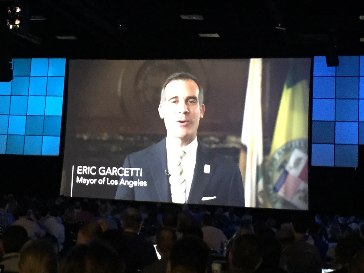
9:08 - Jack introducing Mayor Eric Garcetti from the City of Los Angeles. Video of Mayor Garcetti describing their Esri Partnership and their GeoHub Portal.
Lilian Coral, LA Chief Data Officer - Describing GeoHub and how is provides better access to real-time data. Lilian introducing Vision Zero which is a citywide effort brings together transportation engineers, police officers, advocates, and policymakers to work together towards creating safer streets.

9:22 - Our Work (Esri technology and supporting our users)
ArcGIS
- A complete web GIS platform
- Enables multiple types of systems
ArcGIS is Evolving - Moving from simply supporting client server to
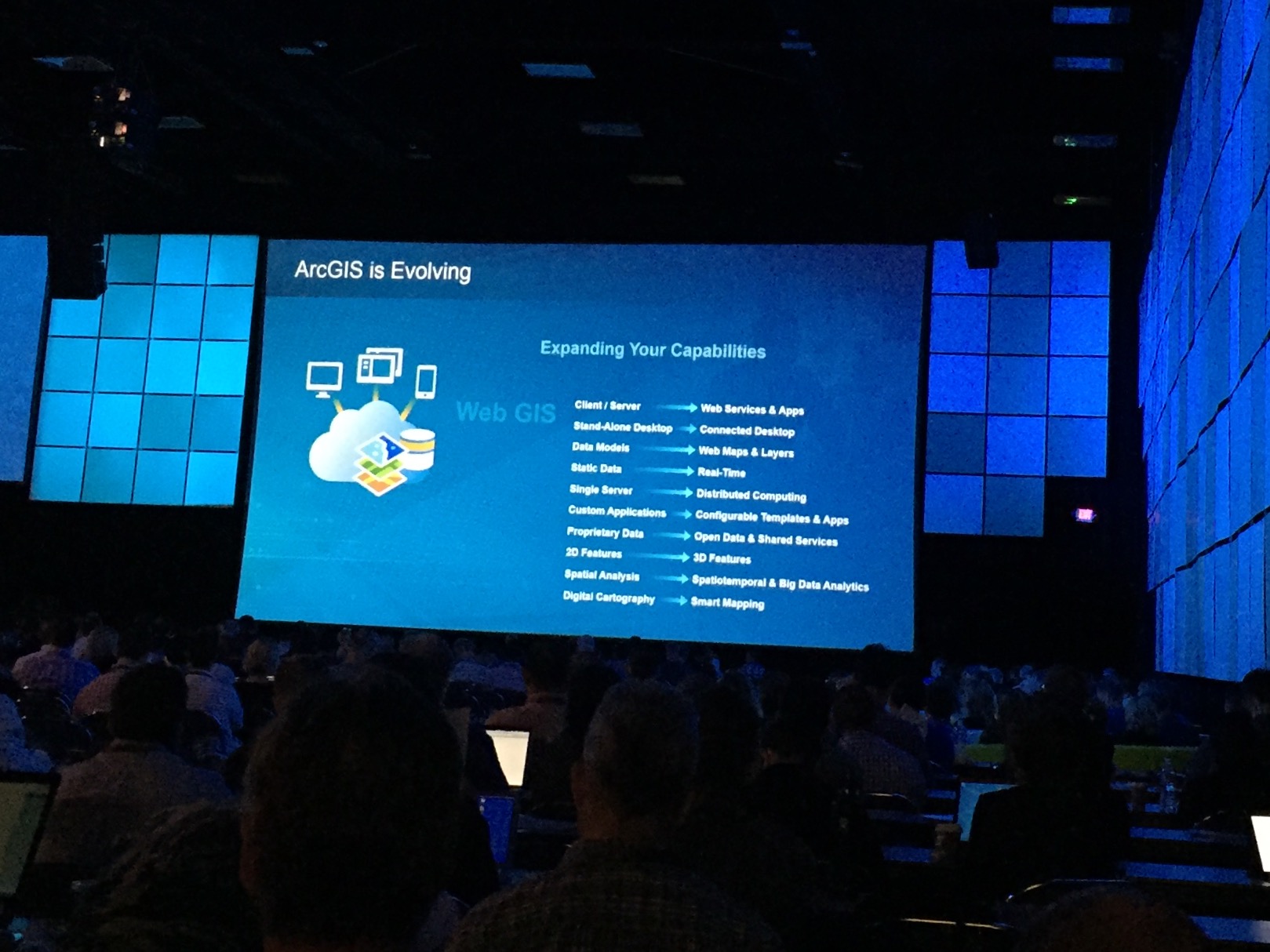
ArcGIS Capabilities are Advancing
- Data Management and Editing
- Field GIS - Taking GIS Beyond the Office
- Living Atlas - Ready-to-use Maps and Data
- Esri has a new partnership with Digital Globe to get their best imagery for the entire planet.
- Mapping and Visualization
- Isights - Transforming understanding with exploratory Analysis
9:32 - Linda Beale showing the all new Insights application. Spatial Analysis plays a big role in this app.
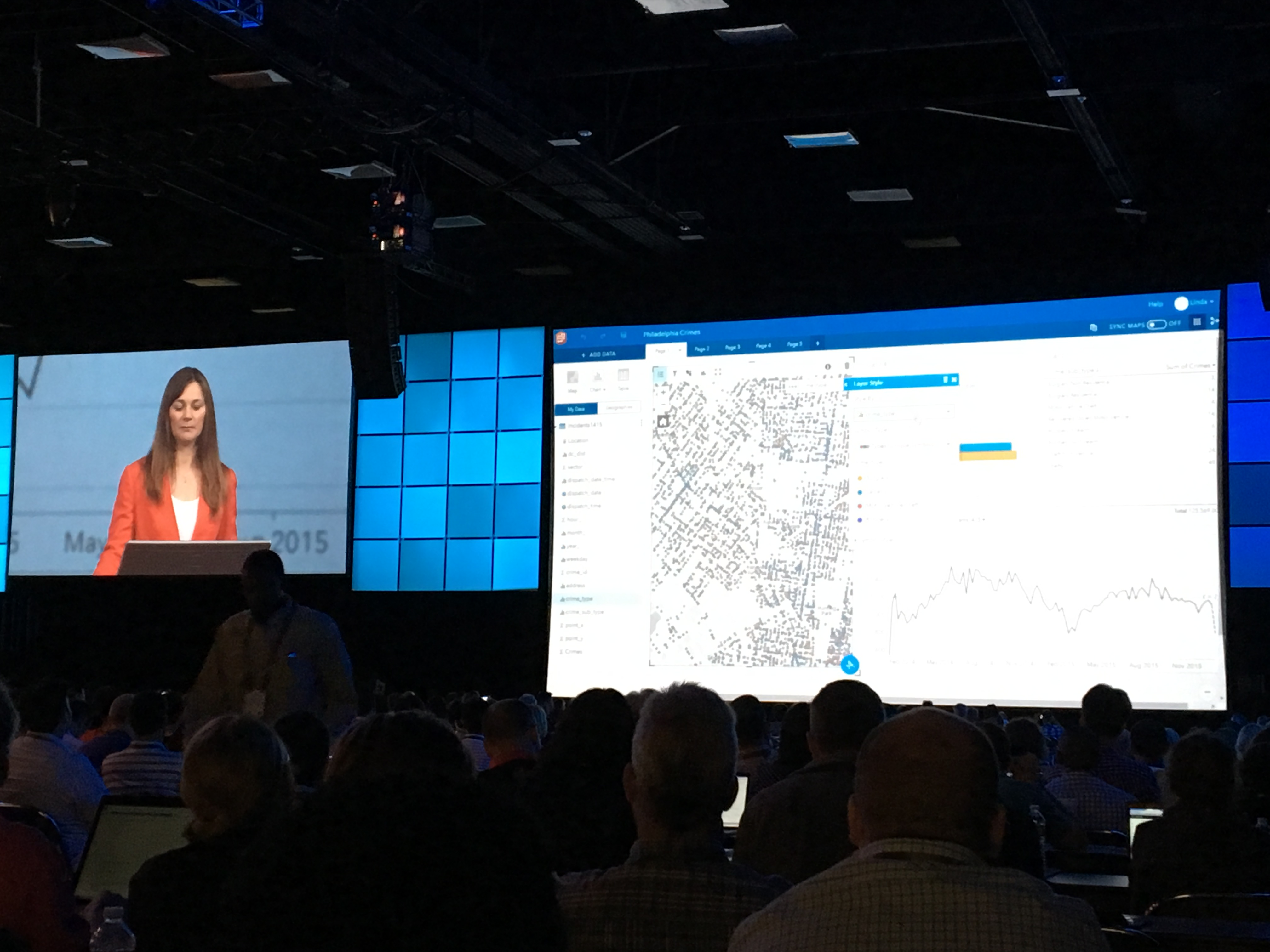
During the analysis, everything is automatically recorded so that processes can be rerun.
Insights is being licenses as premium ArcGIS service.
ELA Users will receive on prem version without cost.
- Spatial Analysis - Introducing new technologies and methods
- R - ArcGIS (Project R) is being integrated into ArcGIS
- Big Data - GeoAnalytics and visualization of massive data
Suzanne Foss - Demoing GeoAnalytic capabilities with a great example of fraud analysis and processing billions of records.
- 3D - New and improved capabilities across the platform
9:52 - Smart 3D Cities - Brooks Patrick
- Imagery - Improved capabilities for ortho mapping, image management and analysis
- Drone2Map for ArcGIS being release this week.
- Apps - Extending ArcGIS capabilities everywhere
- Open-Source Maps and Apps
- App Builder - Easy-to-configure and Create pps
- Web Apps
- Web AppBuilder - Web AppBuilder for ArcGIS
- AppStudio - @App_Studio
- Development and Scripting Tools- For extending, customizing, and embedding
- ArcGIS Code Sharing - Reincarnated ArcScripts
- ArcGIS is Open and Interoperable
- Open Standards and Formats
- Product Integration
- Open Software
ArcGIS Platform Components
- ArcGIS Desktop - Professional GIS
- ArcMap - Continues to be supported
- ArcGIS Pro - Investing in the development of pro to work alongside of ArcMap
- ArcGIS Online - Host Web GIS
- 3.2 Million Users
- 94 Billions Map Views
- 6.2 Million items
- 15.3 open data downloads

- ArcGIS Server - Web GIS in your own infrastructure
- ArcGIS Portal Replication
- Specialized Products - Providing Focus Applications
- Geodesign
- Decision Support
- Domain-Specific
10:06 - Road Map - Incremental and Groundbreaking Advancements

- Esri - Serving our users
- Advancing GIS and Spatial Science
- Professional Development - Lifelong Learning
- Esri Young Professionals Network
- Esri Young Professionals Network
- Self-Paced Learning is now free to all users
- Partner Ecosystem - Committed to Your Success
- Special Relationships - Enriching our user community making a difference
- Education (Education) - Building the Next Generation

10:15 - BREAK
10:30 - Lauren Bennett - Welcomes up back and invites us to take a look at how GIS is enabling a smarter world
The Living Atlas of the Works - Deane Kensok
- Content
- Imagery
- Landscape
- Earth observations
- Boundaries and Places
- Vector Basemaps
A Symphony of Apps - Jean Gea
- Apps for the Field
- Apps for the Office
- Apps for the Community
- AppBuilders - No Coding Required
- Open Source Apps for Industries

10:48 - Auckland Council - Creating the worlds most livable city
Ian Smith and Lauren McAarthy
Five Steps to Maximizing Web GIS
- Create Destinations
- Integrate Systems
- Configure First
- Apps for Efficiency
- Maps for Communications
11:00 - ArcGIS Pro (ArcGIS Pro) - Flora Vale
- Smart mapping help us to visualize and integrate more data at once
- Charting visualizations
- Explore new relationships between data
- Integrates with Living Atlas
- Flora used ArcGIS Pro for finding favorite music venues in downtown and how to find the best place to hold a music festival to demonstrate the new tools.
11:05 - Guy Carpenter
Shannon Peterson & Brian Adam
- Exposure Assessment
- Multiple Exposures
- Seismic Modeling
- Building Accumulations
- Growing the Business

11:15 - Remote Sensing (Imagery and Remote Sensing) - Peter Becker
- ArcGIS Online (ArcGIS Online) imagery analysis
- ArcGIS Pro - Classification Tools that works with data from ArcGIS Online
- Drone2Map for ArcGIS provides a way to collect imagery and LIDAR

11:21 - City of New Orleans
Lamar Gardere, Greg Hymel & James Raasch
- Where Y'At
- NoticeMe - Land use changes
- RoadWorks - Communicating road work project information
- 311 Street Flooding
- Adopt a Catch Basin
- Water Management Projects in New Orleans

11:34 - Real-Time GIS - Suzanne Foss & Adam Mollenkopf
- City of Auckland: Real-Time Transit
- Real-Time as a Managed Service

11:39 - 3D and Global Visualization - Jo Fraley
- Taking 2D data and making a 3D map
- Visualizing data analysis in 3D (Water modeling)
- Can Publish 3D packages to ArcGIS
- ArcGIS Earth
- Visualize KML data in a simple application
- Support for 3D meshes

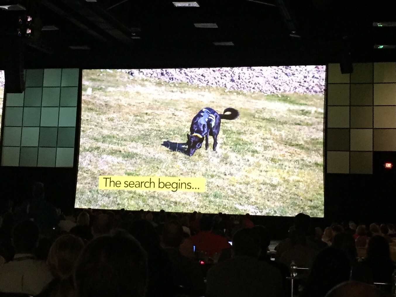
11:46 - Frozen in Time - A History of Life and the Moments of Death at Sandby Borg
Kalmar County Museum - Nicholas Nilsson & Fredrik Gunnarsson

Use of archeology dog and Collector for ArcGIS (Collector for ArcGIS)
11:57 - Runtime Applications - Adrien Meriaux
Virtual Archeology Android App

12:04 - BREAK for lunch - Return at 2:00pm
Check out 2016 Plenary Part 2: the live blog for the afternoon plenary session.
You must be a registered user to add a comment. If you've already registered, sign in. Otherwise, register and sign in.