Turn on suggestions
Auto-suggest helps you quickly narrow down your search results by suggesting possible matches as you type.
Cancel
- Home
- :
- All Communities
- :
- Products
- :
- Data Management
- :
- Data Management Questions
- :
- Re: How to create filled contour lines
Options
- Subscribe to RSS Feed
- Mark Topic as New
- Mark Topic as Read
- Float this Topic for Current User
- Bookmark
- Subscribe
- Mute
- Printer Friendly Page
How to create filled contour lines
Subscribe
8057
8
02-26-2013 02:43 AM
02-26-2013
02:43 AM
- Mark as New
- Bookmark
- Subscribe
- Mute
- Subscribe to RSS Feed
- Permalink
- Report Inappropriate Content
Hi, I am quite new to ArcGIS, I'm an undergrad at Uni.
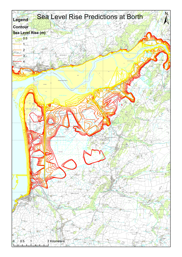
I am currently stuck trying to create filled contour lines of my map of sea level rise like this: http://blogs.esri.com/esri/arcgis/files/2012/11/screenShot.png
These are the stages I've currently completed:
1. Imported the .tif map files from Digimap and Mosaic'd them together
2. Imported the .tif profile DTM files from Digimap and Mosaic'd them together
3. Extracted contour lines at an interval of 0.5m from the DTM using the Arc Toolbox: Spatial Analyst Tools>Surface>Contour
4. Changed the contour lines properties from 'Single symbol' to 'Graduated colours' under the Symbology tab
5. Changed the range to show only: 0.0-0.5, 0.6-1.0, 1.1-2.0, 2.1-3.0 and 3.1-4.0 meters
This produces the attached map:
So yeah I don't know how to create filled contour lines, without resorting to using MS Paint or something.
Any help would be much appreciated!
Thanks
Mike
8 Replies
02-26-2013
04:09 AM
- Mark as New
- Bookmark
- Subscribe
- Mute
- Subscribe to RSS Feed
- Permalink
- Report Inappropriate Content
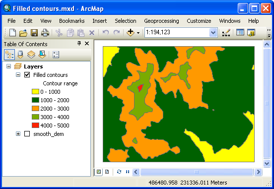
I suspect that they symbolized the DEM and not the contour lines.
02-26-2013
07:16 AM
- Mark as New
- Bookmark
- Subscribe
- Mute
- Subscribe to RSS Feed
- Permalink
- Report Inappropriate Content
Mike,
The Spatial Analyst team recently published a blog post introducing the "Spatial Analyst Supplemental tools". One of the supplemental tools is a Filled Contours tool.
You can download the tools here:
http://www.arcgis.com/home/item.html?id=3528bd72847c439f88190a137a1d0e67
Requirements:
ArcGIS 10.1 Service Pack 1 and Spatial Analyst Extension
The Filled Contours tool requires ArcGIS for Desktop Advanced or ArcGIS for Server Advanced and Spatial Analyst Extension.
Best,
Eric
02-26-2013
07:21 AM
- Mark as New
- Bookmark
- Subscribe
- Mute
- Subscribe to RSS Feed
- Permalink
- Report Inappropriate Content
or look at http://www.arcgis.com/home/item.html?id=22d6a18db6e246a08a9411fcc5a1f32d
if you only have ArcGIS 10
if you only have ArcGIS 10
02-26-2013
12:18 PM
- Mark as New
- Bookmark
- Subscribe
- Mute
- Subscribe to RSS Feed
- Permalink
- Report Inappropriate Content
or look at http://www.arcgis.com/home/item.html?id=22d6a18db6e246a08a9411fcc5a1f32d
if you only have ArcGIS 10
I've download and extracted the zip files, I tried to add the script to ArcGIS 10 using the ArcCatalog? by looking on other threads but I've been unsuccessful. Could you explain how I add the tool please?
Thank you everyone for your help!
Mike
02-26-2013
02:26 PM
- Mark as New
- Bookmark
- Subscribe
- Mute
- Subscribe to RSS Feed
- Permalink
- Report Inappropriate Content
In ArcMap, use the Catalog window and browse to the folder where you extracted the zip files. There is a toolbox, expand it and you'll find the script tool. Double click it.
Regards
Steve
Regards
Steve
03-11-2013
11:41 PM
- Mark as New
- Bookmark
- Subscribe
- Mute
- Subscribe to RSS Feed
- Permalink
- Report Inappropriate Content
03-12-2013
08:10 AM
- Mark as New
- Bookmark
- Subscribe
- Mute
- Subscribe to RSS Feed
- Permalink
- Report Inappropriate Content
Do you have 10.1 and do you have a Spatial Analyst license?
03-12-2013
08:45 PM
- Mark as New
- Bookmark
- Subscribe
- Mute
- Subscribe to RSS Feed
- Permalink
- Report Inappropriate Content
Yes. This software is company-owned, however.