- Home
- :
- All Communities
- :
- Products
- :
- 3D
- :
- 3D Mapping Questions
- :
- create polygon(s) that represent a 100ft set back...
- Subscribe to RSS Feed
- Mark Topic as New
- Mark Topic as Read
- Float this Topic for Current User
- Bookmark
- Subscribe
- Mute
- Printer Friendly Page
create polygon(s) that represent a 100ft set back from the ridgeline
- Mark as New
- Bookmark
- Subscribe
- Mute
- Subscribe to RSS Feed
- Permalink
- Report Inappropriate Content
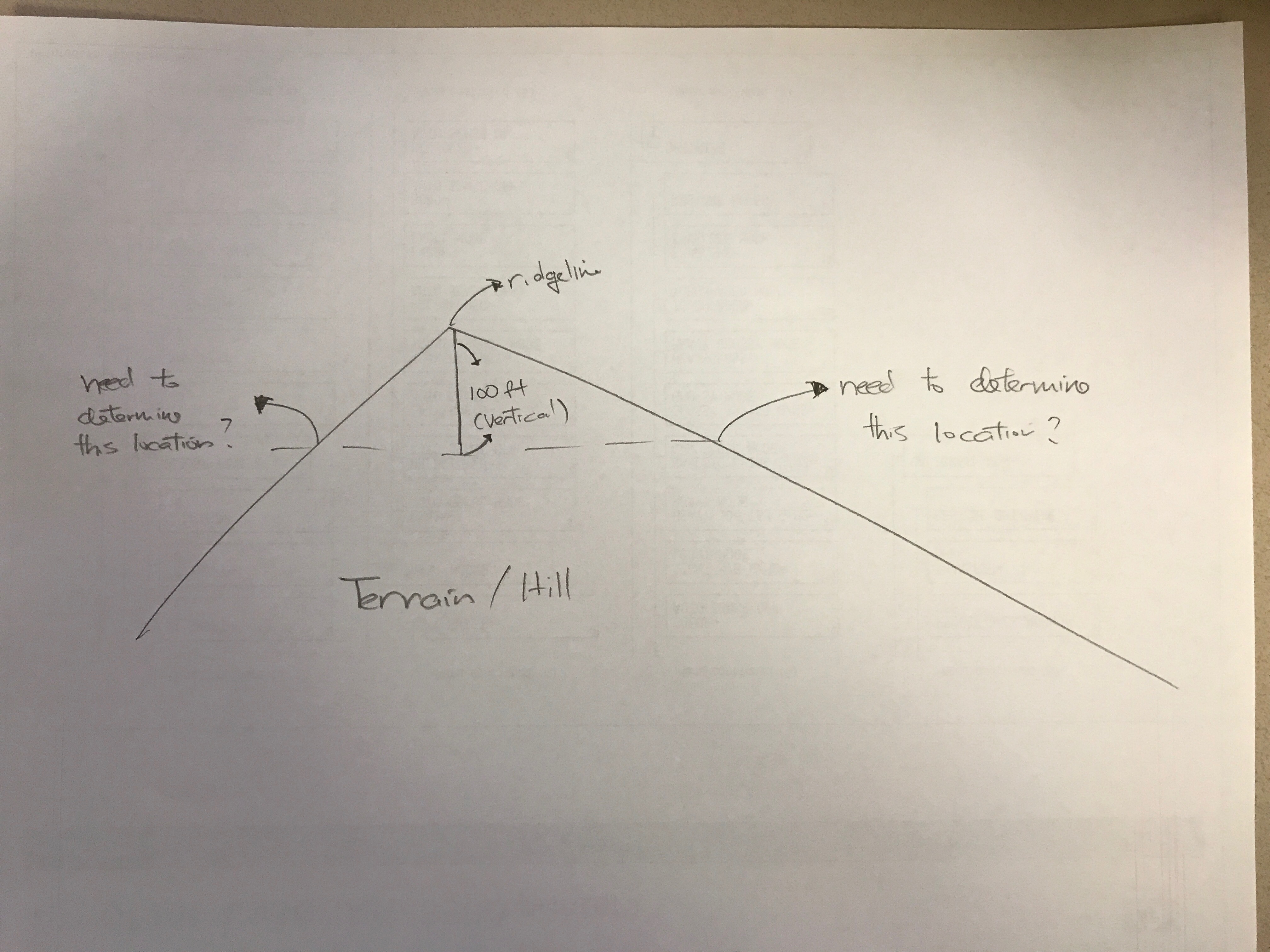
I am seeking assistance on how to create intersecting polygon(s) that is/are derived from 100ft vertical set back from the ridgeline. Basically, I have been tasked by our Planning Dept. to show deviation of 25% slope, ridgeline, and 100ft vertical set back from the ridgeline of our surround terrain. My dilemma is how to create the vertical 100ft set back and determining the intersecting points and/or polygons on the terrain. Please see attached pic. Hopefully the pic can explain what I need to figure out. Thank you.
Solved! Go to Solution.
Accepted Solutions
- Mark as New
- Bookmark
- Subscribe
- Mute
- Subscribe to RSS Feed
- Permalink
- Report Inappropriate Content
Thanks to everyone who replied to my question. I also wanted to thank Hayward's GIS coordinator, ESRI's Spatial and 3D analyst software engineers for guiding me.
Posting my how to doc for anyone who may encounter similar question. Once the procedure is established, processing and data organization time may take the bulk of the time. Ran this on ArcGIS Pro with 3D and Spatial analyst extensions
- Mark as New
- Bookmark
- Subscribe
- Mute
- Subscribe to RSS Feed
- Permalink
- Report Inappropriate Content
For starters in providing a solution, can you provide the following:
1. Which software package are you using? ArcGIS Desktop? ArcGIS Pro? Another?
2. What version is the software?
3. If it is ArcGIS Desktop or ArcGIS Pro, do you have access to the Spatial Analyst or 3D Analyst Extensions?
4. Is vertical elevation data available for your planning area? What format? Elevation points, a raster surface?
5. Are the ridgelines already derived or will part of the task be to derive them to then use in the analysis?
Chris Donohue, GISP
- Mark as New
- Bookmark
- Subscribe
- Mute
- Subscribe to RSS Feed
- Permalink
- Report Inappropriate Content
If you have ArcGIS Desktop, access to the Spatial Analyst extension, and access to elevation data, the general workflow would be to create the initial elevation surface, derive the ridgelines, subtract 100 feet from the ridgelines layer to make a new surface, then use that new surface to intersect the original surface, then convert the resulting intersect to vector. The particulars of each step will depend, however, on what you have access to.
Chris Donohue, GISP
- Mark as New
- Bookmark
- Subscribe
- Mute
- Subscribe to RSS Feed
- Permalink
- Report Inappropriate Content
Good day Chris, Thanks for prompt suggestion. Never thought of subtracting 100ft from the ridgeline. I will give this.
I have access to both ArcGIS Pro and Map at Adv level. Thus far, all has been created except the intersecting part. Thanks again.
- Mark as New
- Bookmark
- Subscribe
- Mute
- Subscribe to RSS Feed
- Permalink
- Report Inappropriate Content
Hi Chris,
What are the GP tools that you would suggest to intersect new and existing surface then derive a polygon or polyline from it? The end result our Planner is looking for is a polygon or polyline layer that traverse along the hillsides. FYI, I have are my original raster DEM and new raster DEM that was derived from Ridgeline minus 100ft. Thank you.
BTW, I have both 3D and Spatial Analysts extension available. Been working in ArcGIS pro environment.
- Mark as New
- Bookmark
- Subscribe
- Mute
- Subscribe to RSS Feed
- Permalink
- Report Inappropriate Content
Related to your picture, If you know the ridgeline level (elevation) . (you can identify the elevation or Extract Values to Points).
To determine the intersect location, Just you need to create specific Contour lines use Contour List tool and the value is ( Z of Ridgeline - 100 ft.) and extract where it intersect with your figure in the picture.
- Mark as New
- Bookmark
- Subscribe
- Mute
- Subscribe to RSS Feed
- Permalink
- Report Inappropriate Content
Thanks to everyone who replied to my question. I also wanted to thank Hayward's GIS coordinator, ESRI's Spatial and 3D analyst software engineers for guiding me.
Posting my how to doc for anyone who may encounter similar question. Once the procedure is established, processing and data organization time may take the bulk of the time. Ran this on ArcGIS Pro with 3D and Spatial analyst extensions