- Home
- :
- All Communities
- :
- Products
- :
- 3D
- :
- 3D Mapping Questions
- :
- Re: How to perform Tasseled Cap Function/"Greennes...
- Subscribe to RSS Feed
- Mark Topic as New
- Mark Topic as Read
- Float this Topic for Current User
- Bookmark
- Subscribe
- Mute
- Printer Friendly Page
How to perform Tasseled Cap Function/"Greenness" Factor in GIS?
- Mark as New
- Bookmark
- Subscribe
- Mute
- Subscribe to RSS Feed
- Permalink
- Report Inappropriate Content
Good morning,
I'm a beginner analyst attempting to map impervious water surfaces of land parcels in a city. The research I did suggested I use what is called the "Tasseled Cap" function in GIS to estimate the vegetation aka "Greenness" factor of the raster image to automatically make a distinction between pixels that are vegetation (some minimum level of green) and not vegetation (impervious).
I have no idea how to do this as my experience with Python and SQL is extremely limited and I can't find a built in function to do this for me.
Would anyone happen to have any helpful hints?
Cheers
- Mark as New
- Bookmark
- Subscribe
- Mute
- Subscribe to RSS Feed
- Permalink
- Report Inappropriate Content
Basically you have a 'picture' ... only red, green and blue. Acquire the imagery that is needed for the analysis or follow in your 'superiors' footsteps. Have you checked to see if imagery is available for your area even at a different resolution?
- Mark as New
- Bookmark
- Subscribe
- Mute
- Subscribe to RSS Feed
- Permalink
- Report Inappropriate Content
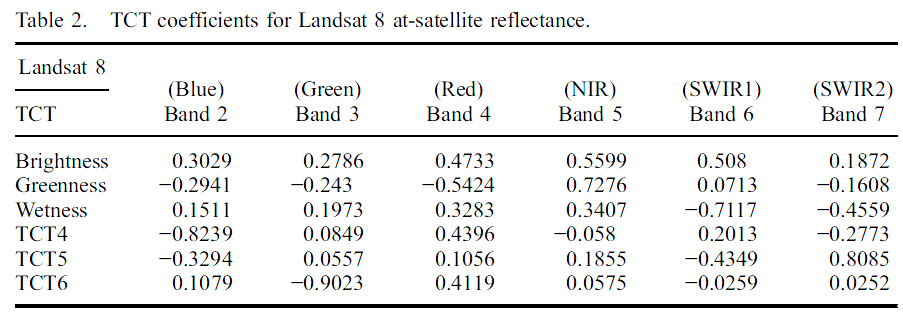
See the Landsat 8 coefficients here https://www.tandfonline.com/doi/full/10.1080/2150704X.2014.915434
Download the article (three cheers for "open access" provided by the authors) https://www.researchgate.net/publication/262005316_Derivation_of_a_tasselled_cap_transformation_base...
@JayantaPoddar I confirm that it must be used on at-satellite reflectance, it is mentioned also in literature, including the above cited article and https://yceo.yale.edu/tasseled-cap-transform-landsat-8-oli
- Mark as New
- Bookmark
- Subscribe
- Mute
- Subscribe to RSS Feed
- Permalink
- Report Inappropriate Content
Also found TCT coefficients for L8.
Tasseled Cap transformation for Landsat 8 Imagery.pdf
Think Location
- Mark as New
- Bookmark
- Subscribe
- Mute
- Subscribe to RSS Feed
- Permalink
- Report Inappropriate Content
- Mark as New
- Bookmark
- Subscribe
- Mute
- Subscribe to RSS Feed
- Permalink
- Report Inappropriate Content
Hi-
I worked up the Landsat 8 parameters for TCT into a toolbox. It is on GeoNet here:
I think the script needs to be exported and re-added to the toolbox due to a relative-vs-absolute path problem, but it's a well written python script. The original script is on GitHub at GeospatialDaryl/LandSat8_TasseledCapTransform · GitHub
I'll look to try to get the TBX formatted right today.
Thanks-
Daryl
- Mark as New
- Bookmark
- Subscribe
- Mute
- Subscribe to RSS Feed
- Permalink
- Report Inappropriate Content
Wow that is super useful. Thank you!
- Mark as New
- Bookmark
- Subscribe
- Mute
- Subscribe to RSS Feed
- Permalink
- Report Inappropriate Content
Could someone help me out with getting this toolbox to work? I've not worked with toolboxes much before so I'm unable to figure this one out.
- Mark as New
- Bookmark
- Subscribe
- Mute
- Subscribe to RSS Feed
- Permalink
- Report Inappropriate Content
alternatives in Pro
- Mark as New
- Bookmark
- Subscribe
- Mute
- Subscribe to RSS Feed
- Permalink
- Report Inappropriate Content
Lol. I guess that works for me. Thanks. I should have looked at Pro.
- « Previous
-
- 1
- 2
- Next »
- « Previous
-
- 1
- 2
- Next »