- Home
- :
- All Communities
- :
- Products
- :
- 3D
- :
- 3D Questions
- :
- Re: Comparison of created DEM from TIN and SPLINE
- Subscribe to RSS Feed
- Mark Topic as New
- Mark Topic as Read
- Float this Topic for Current User
- Bookmark
- Subscribe
- Mute
- Printer Friendly Page
- Mark as New
- Bookmark
- Subscribe
- Mute
- Subscribe to RSS Feed
- Permalink
- Report Inappropriate Content
Hello everybody.
I have two layers of DEM - one is created with SPLINE and second is created with TIN.
How do I compare their succes, accuracy...? Can I use some kind of analysis? Can anybody help, please?
Thank you so much 
Solved! Go to Solution.
Accepted Solutions
- Mark as New
- Bookmark
- Subscribe
- Mute
- Subscribe to RSS Feed
- Permalink
- Report Inappropriate Content
Hello SV,
The Tin should be more accurate than the Spline. You can compare them by adding both rasters to ArcMap, using the Image Analysis Window under Windows at the top of ArcMap and then click on the Difference Button to get the difference between the two. You could then export the difference image and run statistics on it to get more detailed information on the differences between the images. Just wondering, what's the source of your data in the DEM?


Thanks,
Arthur Crawford
- Mark as New
- Bookmark
- Subscribe
- Mute
- Subscribe to RSS Feed
- Permalink
- Report Inappropriate Content
Hello SV,
From the Help: "Spline interpolates a raster surface from points using a two-dimensional minimum curvature spline technique. The resulting smooth surface passes exactly through the input points."
Looking at the graphic below suggest that the Spline in orange might create artificially high and low points in the DEM. A tin usually creates more of a triangle effect with a DEM that is shown in Red below.
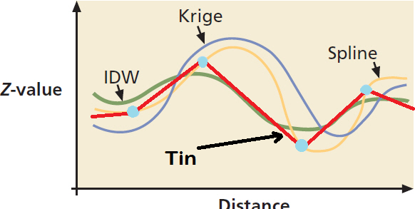
I would suggest trying to use the Topo to Raster which interpolates a hydrologically correct raster surface from point, line, and polygon data. ArcGIS Help 10.1
Thanks,
Arthur Crawford
- Mark as New
- Bookmark
- Subscribe
- Mute
- Subscribe to RSS Feed
- Permalink
- Report Inappropriate Content
thank you, mr. Crawford
guess i was badly expressed, i am not good in english, but i meant - can i find out some differences between my two layers (1 from tin, 1 from spline)? i mean differences in term of heights, accuracy and so on...
thank you
- Mark as New
- Bookmark
- Subscribe
- Mute
- Subscribe to RSS Feed
- Permalink
- Report Inappropriate Content
Hello SV,
The Tin should be more accurate than the Spline. You can compare them by adding both rasters to ArcMap, using the Image Analysis Window under Windows at the top of ArcMap and then click on the Difference Button to get the difference between the two. You could then export the difference image and run statistics on it to get more detailed information on the differences between the images. Just wondering, what's the source of your data in the DEM?
Thanks,
Arthur Crawford
- Mark as New
- Bookmark
- Subscribe
- Mute
- Subscribe to RSS Feed
- Permalink
- Report Inappropriate Content
Lidar data
- Mark as New
- Bookmark
- Subscribe
- Mute
- Subscribe to RSS Feed
- Permalink
- Report Inappropriate Content
And thank you so so much!
- Mark as New
- Bookmark
- Subscribe
- Mute
- Subscribe to RSS Feed
- Permalink
- Report Inappropriate Content
when you have different data structures, you have to convert to a standard form in order to perform differences. The process of performing the conversion (for example, from TIN to raster) brings with it a series of concerns as well. I could see comparing rasters to raster etc, but I would advise against comparing between structures. A comparison between interpolation methods is a common student project, however, I always caution against saying one is better than the other. One may be more 'appropriate' given certain data conditions, for example, but the term 'better' is too subjective to be valid.
- Mark as New
- Bookmark
- Subscribe
- Mute
- Subscribe to RSS Feed
- Permalink
- Report Inappropriate Content
I completely agree with you about using "appropriate" rather than "better"...always depends on what we have to do