- Home
- :
- All Communities
- :
- User Groups
- :
- 911 GIS
- :
- Questions
- :
- Re: Homogenisation
- Subscribe to RSS Feed
- Mark Topic as New
- Mark Topic as Read
- Float this Topic for Current User
- Bookmark
- Subscribe
- Mute
- Printer Friendly Page
- Mark as New
- Bookmark
- Subscribe
- Mute
- Subscribe to RSS Feed
- Permalink
- Report Inappropriate Content
Hi,
I am new to ArcGIS. I am a bit stuck. I am adding a 2 layers in ArcMap :
ArcGIS coordinate system
* Type Geographic
* Geographic coordinate reference GCS_WGS_1984
and
* Type Projected
* Geographic coordinate reference GCS_MGI
* Projection MGI_Austria_GK_M31
I cannot see the projected layer - when I Define Projection as MGI, they are both there, but very FAR apart. Is it the Datum that is incorrect? How can I correct this?
Thanks in advance
Terri
Solved! Go to Solution.
- Mark as New
- Bookmark
- Subscribe
- Mute
- Subscribe to RSS Feed
- Permalink
- Report Inappropriate Content
Well given the easting and northing values of the 2nd image, I think it is within the correct latitudinal range. The only thing to resolve now is what projected coordinate system would give rise to those values, hence my guess of some UTM or transverse Mercator based projection since 45 degrees is 1/2 way between the equator and the pole and the original definition of the metre was 1/10,000,000 of the distance between the equator and the pole... ergo, 5,000,000 metres-ish would be an appropriate northing. As for the easting, you should be able to figure what UTM zone you are in and whether your longitude falls to the east or west of the central meridian for the utm zone that covers the latitude and longitude range.
Of course this doesn't rule out any other projections that you might encounter in your studies that are unique or widely used in your area. Trial and error and/or comparison to a known dataset are your only options to narrow down appropriate candidates.
- Mark as New
- Bookmark
- Subscribe
- Mute
- Subscribe to RSS Feed
- Permalink
- Report Inappropriate Content
Thank you for the mail. The correct projected Coordinate system for LULC_NAWI is WGS_1984_UTM_Zone_33N.
Go to the Shapefile Properties from ArcCatalog > XY Coordinate System Tab. And define WGS_1984_UTM_Zone_33N as the coordinate system.
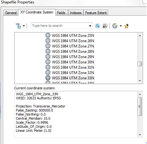
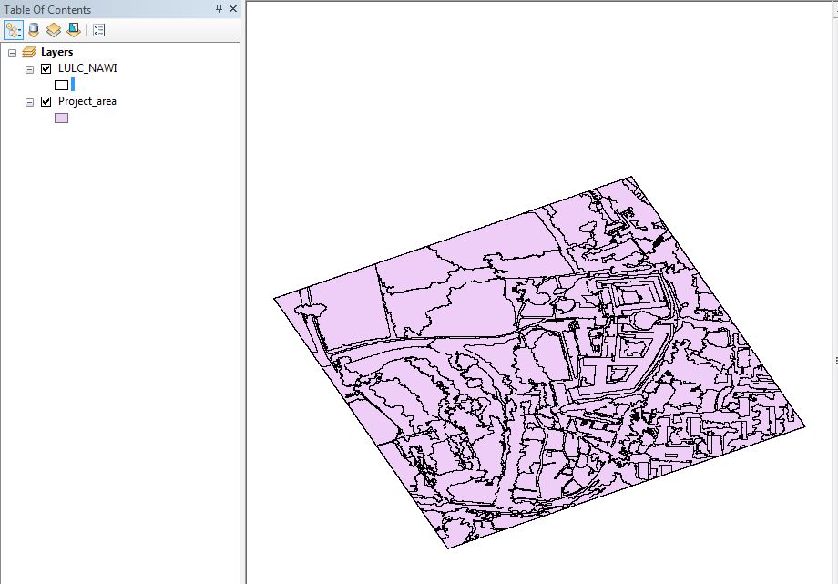
The Project_area and LULC_NAWI will then exactly overlay on each other.
Think Location
- Mark as New
- Bookmark
- Subscribe
- Mute
- Subscribe to RSS Feed
- Permalink
- Report Inappropriate Content
Excellent - that worked!
Please could you tell me how you ascertained that correct projected
Coordinate system - I hunted through my list for hours and tried MANY.
There must be an easier way.
Terri
- Mark as New
- Bookmark
- Subscribe
- Mute
- Subscribe to RSS Feed
- Permalink
- Report Inappropriate Content
UTM is a very common PCS used globally. It was just a hunch.
Check How to calculate the UTM zone using longitude values (Decimal Degrees)
Think Location
- Mark as New
- Bookmark
- Subscribe
- Mute
- Subscribe to RSS Feed
- Permalink
- Report Inappropriate Content
plus your longitudes are in the appropriate range for that utm 
- Mark as New
- Bookmark
- Subscribe
- Mute
- Subscribe to RSS Feed
- Permalink
- Report Inappropriate Content
Thanks - a very helpful link.
Terri
- Mark as New
- Bookmark
- Subscribe
- Mute
- Subscribe to RSS Feed
- Permalink
- Report Inappropriate Content
Try this: add one of the layers to an ArcMap session, right click and Zoom to Layer. In another ArcMap session do the same thing with the other layer. If one of them 'dissapears' from your screen, that's the problem child and it has an extent problem.
- Mark as New
- Bookmark
- Subscribe
- Mute
- Subscribe to RSS Feed
- Permalink
- Report Inappropriate Content
Hi,
I am also new in GIS.
How do I know name for the EPSG 31258 projection?
- « Previous
-
- 1
- 2
- Next »
- « Previous
-
- 1
- 2
- Next »