- Home
- :
- All Communities
- :
- Products
- :
- ArcGIS Business Analyst
- :
- ArcGIS Business Analyst Questions
- :
- Re: Import shapefile problem
- Subscribe to RSS Feed
- Mark Topic as New
- Mark Topic as Read
- Float this Topic for Current User
- Bookmark
- Subscribe
- Mute
- Printer Friendly Page
Import shapefile problem
- Mark as New
- Bookmark
- Subscribe
- Mute
- Subscribe to RSS Feed
- Permalink
- Report Inappropriate Content
Hello,
I have a shapefile I would like to import into Business Analyst/Community Analyst to use as part of a Smart Map Search. I go through the steps of importing a shapefile, but then I get a warning/error message that says that the shapefile has more than 100 records so only the first 100 will be imported. Not great, but I decide to proceed in order to see what I get.
When I click on the "OK" button, nothing happens.
That's not OK. Any idea what is happening?
Allen Risley
GIS Specialist
Cal State University San Marcos
- Mark as New
- Bookmark
- Subscribe
- Mute
- Subscribe to RSS Feed
- Permalink
- Report Inappropriate Content
Allen,
Take a look at this article. There are some suggestions on what to try with an error like this:
- Mark as New
- Bookmark
- Subscribe
- Mute
- Subscribe to RSS Feed
- Permalink
- Report Inappropriate Content
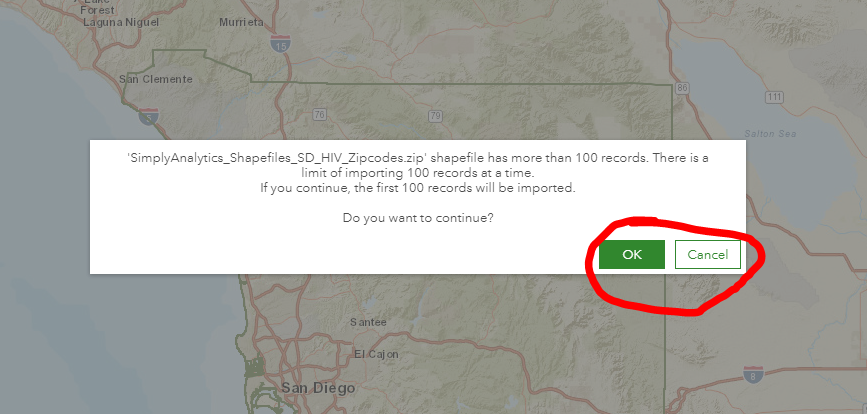
Here's a screenshot of the error message:
- Mark as New
- Bookmark
- Subscribe
- Mute
- Subscribe to RSS Feed
- Permalink
- Report Inappropriate Content
According to that article, here are the restrictions for shapefiles for Business Analyst:
a. A maximum of 100 records and a file size limit of 3 MB.
b. Only point and polygon geometry (no lines and no multi-part geometry) can be added.
c. Compression formats other than a .zip archive are not supported
- Mark as New
- Bookmark
- Subscribe
- Mute
- Subscribe to RSS Feed
- Permalink
- Report Inappropriate Content
The warning message is stating that there are more than 100 records so it will import the first 100. So I try clicking on the OK button to continue and nothing happens. Shouldn't something happen when I click on the OK button?
- Mark as New
- Bookmark
- Subscribe
- Mute
- Subscribe to RSS Feed
- Permalink
- Report Inappropriate Content
Allen,
Is your shapefile larger than 3 MB?
Does your shapefile contain just points or just polygons? Or are there lines/multi-parts in there?
Are you using a zip file for your shapefile?
Just to check, can you load your zipped up shapefile into regular ArcGIS Online?
You should be able to load it there. If you are seeing problems there, then there might be bigger problems that need to be worked out:
- Mark as New
- Bookmark
- Subscribe
- Mute
- Subscribe to RSS Feed
- Permalink
- Report Inappropriate Content
Hi Adrian,
The zipped shapefile is 1.3 MB. It is a .zip file. It is a polygon file, wit the polygons being zipcodes, so the problem might be that there are some multi-part fields in the data.
I added the zipped shapefile as an item in ArcGIS Online with no problems. I then went back to Community Analyst and added the feature service using the Custom Data Setup method. That worked, so the immediate problem is solved. Thanks you for your help - that article is now in my list of bookmarks.
The point behind this exercise is that I am working with public health students who have limited GIS skills but want to include some GIS analysis in their work. I'm trying to document as simple a set of steps at possible so the students can be somewhat self-sufficient at this task. The students are designing health-based intervention programs, and part of their design is to select locations for the mythical intervention offices near the target populations. For several semesters I have been teaching students how to use Smart Map Search to select data variables relevant to their health condition of interest and then use the sliders to isolate the census tracts most likely to have greater proportions of their target population. One problem we have encountered is that Community/Business Analyst does not have a lot of health condition/ailment data. Our university recently licensed Simply Analytics, which has more of this data, so we are exporting shapefiles to then import into CAO/BAO to hopefully use in Smart Map Search. Sometimes it's working, sometimes not - but it's a marked improvement over where we were previously.
Thanks for the help!
- Mark as New
- Bookmark
- Subscribe
- Mute
- Subscribe to RSS Feed
- Permalink
- Report Inappropriate Content
I'm glad to hear it is working ok. This sounds like a cool and practical solution for public health students.