- Home
- :
- All Communities
- :
- Products
- :
- ArcGIS GeoPlanner
- :
- ArcGIS GeoPlanner Questions
- :
- Re: GeoPlanner: Failing to Import Features to Scen...
- Subscribe to RSS Feed
- Mark Topic as New
- Mark Topic as Read
- Float this Topic for Current User
- Bookmark
- Subscribe
- Mute
- Printer Friendly Page
GeoPlanner: Failing to Import Features to Scenario
- Mark as New
- Bookmark
- Subscribe
- Mute
- Subscribe to RSS Feed
- Permalink
- Report Inappropriate Content
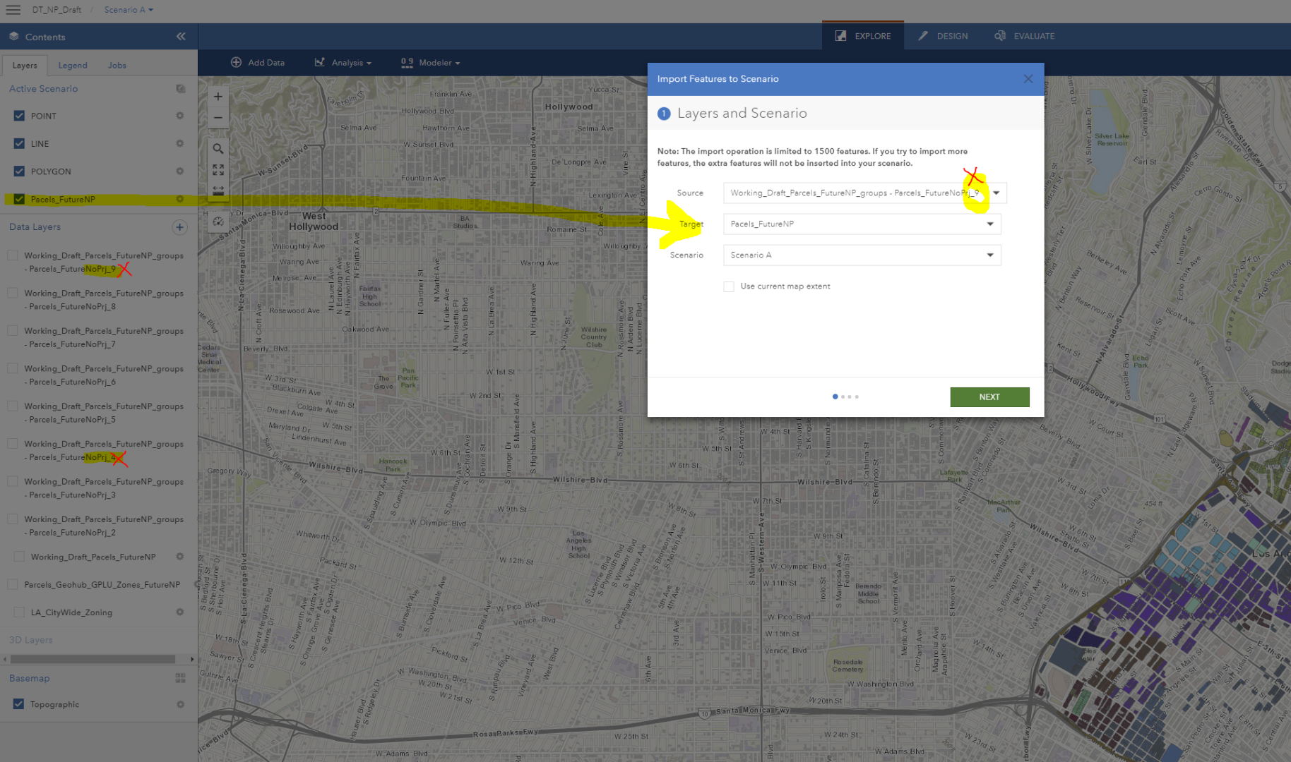
I am setting up an Active Scenario in GeoPlanner and have imported several feature layers from ArcGIS Server (Portal). Since the import limit is 1500 records, I created groups from my feature layer and have them broken out into 9 data layers. My problem is 2 of the 9 feature layers failed during import (group 4 and 9). I can see no clear reason why these two would fail but not any others. Any help or ideas would be greatly appreciated. I have attached an image to help explain the problem.
- Mark as New
- Bookmark
- Subscribe
- Mute
- Subscribe to RSS Feed
- Permalink
- Report Inappropriate Content
Hi Jacqui,
How are you doing? I am a member of the GeoPlanner team and can help you look into your issue. I have a few questions:
- Are you using the ArcGIS Online or ArcGIS Enterprise version of GeoPlanner?
- Is there any way that you would be able to share your data with me? If you're using ArcGIS Online, are you able to make the data public, or share the data with me? My username is kwalton_gadmin.
Thanks,
Kenneth
- Mark as New
- Bookmark
- Subscribe
- Mute
- Subscribe to RSS Feed
- Permalink
- Report Inappropriate Content
Hi Kenneth,
Thank you for your help. I am using ArcGIS Enterprise. I was actually able to get in contact with Rob Stauder, another of the ESRI GeoPlanner team members. We have a call scheduled tomorrow to go over the issue. I hope he can help. If not, you'll be hearing from me. Thanks again for reaching out.
Jacqui
- Mark as New
- Bookmark
- Subscribe
- Mute
- Subscribe to RSS Feed
- Permalink
- Report Inappropriate Content
No problem! I'll check with Rob if he needs any help looking into the issue.
- Mark as New
- Bookmark
- Subscribe
- Mute
- Subscribe to RSS Feed
- Permalink
- Report Inappropriate Content
Hi Jacqui,
I was able to talk with Rob and he shared the data with me. I was able to reproduce the problem, and I believe that I've found the issue. It doesn't seem to like the <NULL> value in the FAR and TFSAR_MAX fields. You can use the Calculate tool in ArcGIS Desktop to change the "<NULL>" values to "N/A". Or, you can do this directly from Portal, which I have provided steps for below. Let me know if this resolves your issue!
Thanks!,
Kenneth
Enable editing for layer
1. In GeoPlanner, click the gear icon next to "countrywide_parcels_04_20_2015 - Parcels_FutureNoPrj_4", then click Properties.
2. Click DETAILS, then VIEW DETAILS.
3. Enter Portal credentials if needed.
4. Click the Settings tab, then under Feature Layer (hosted) Settings > Editing, check the box for "Enable Editing".
5. Scroll down, then click the SAVE button.
Use Calculate tool to update FAR and TFAR_MAX fields
1. In the items details page, click the "Overview" tab, then click the "Open in Map Viewer" button.
2. In the TOC, hover over "countrywide_parcels_04_20_2015 - Parcels_FutureNoPrj_4", then click the "Filter" icon.
3. Set the following filter: FAR contains NULL
4. Click "Add another expresion", then set the following filter: TFAR_MAX contains NULL
5. At the top of the Filter window, set the drop-down for "Display features in the layer that match" to "Any".
6. Click the "APPLY FILTER" button.
7. In the TOC, hover over "countrywide_parcels_04_20_2015 - Parcels_FutureNoPrj_4", then click the "Show Table" icon.
8. Select the first feature in the table, then scroll down to the last feature in the list (if needed), then hold down the SHIFT key and select the last feature in the table.
This should highlight all features in the table.
9. Scroll the table to the right, click the column header for "FAR", then select "Calculate".
10. In the textbox underneath "FAR =", enter the following (including the single quotes): 'N/A'
11. Click the green checkmark to verify the value, then click the CALCULATE button.
12. Repeat steps 8-11 for the "TFAR_MAX" field.
13. In the TOC, hover over "countrywide_parcels_04_20_2015 - Parcels_FutureNoPrj_4", then click the "Filter" icon.
14. Click the REMOVE FILTER button.
15. In the TOC, hover over "countrywide_parcels_04_20_2015 - Parcels_FutureNoPrj_4", click the 3 dots (...) icon, then click "Save Layer".
- Repeat above steps for the "countrywide_parcels_04_20_2015 - Parcels_FutureNoPrj_9" layer.
Disable editing for layer
1. In GeoPlanner, click the gear icon next to "countrywide_parcels_04_20_2015 - Parcels_FutureNoPrj_4", then click Properties.
2. Click DETAILS, then VIEW DETAILS.
3. Enter Portal credentials if needed.
4. Click the Settings tab, then under Feature Layer (hosted) Settings > Editing, uncheck the box for "Enable Editing".
5. Scroll down, then click the SAVE button.
- Retry the import in GeoPlanner.
- Mark as New
- Bookmark
- Subscribe
- Mute
- Subscribe to RSS Feed
- Permalink
- Report Inappropriate Content
Thank you Kenneth. I will try this out tomorrow and let you know if I have any issues.
- Mark as New
- Bookmark
- Subscribe
- Mute
- Subscribe to RSS Feed
- Permalink
- Report Inappropriate Content
Hi Kenneth,
Thank for your help. I was finally able to jump back onto this. Interestingly enough the import for Group 4 was successful but Group 9 failed. See image below. Only 800 of my 934 records imported. Any thoughts?