- Home
- :
- All Communities
- :
- Developers
- :
- JavaScript Maps SDK
- :
- JavaScript Maps SDK Questions
- :
- Re: Spider Line in a 3D (or Curved)
- Subscribe to RSS Feed
- Mark Topic as New
- Mark Topic as Read
- Float this Topic for Current User
- Bookmark
- Subscribe
- Mute
- Printer Friendly Page
- Mark as New
- Bookmark
- Subscribe
- Mute
- Subscribe to RSS Feed
- Permalink
- Report Inappropriate Content
I am using Esri Javascript API 4.6
Is it possible to Assign an elevation at the end of spider lines- from my store point elevation (total Count). or how to curve them as
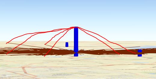
Figure one is what I have so far, when clicked on any store it show a flat spider line (feature Class with definition expression).
Figure 2 is what I need to accomplish.
Solved! Go to Solution.
Accepted Solutions
- Mark as New
- Bookmark
- Subscribe
- Mute
- Subscribe to RSS Feed
- Permalink
- Report Inappropriate Content
Solved by Using Construct Line of sight, and assigning 0 to the elevation in the target field solved it.

- Mark as New
- Bookmark
- Subscribe
- Mute
- Subscribe to RSS Feed
- Permalink
- Report Inappropriate Content
Solved by Using Construct Line of sight, and assigning 0 to the elevation in the target field solved it.
- Mark as New
- Bookmark
- Subscribe
- Mute
- Subscribe to RSS Feed
- Permalink
- Report Inappropriate Content
Did you pre-calculate the elevation in ArcGIS Pro and then published the lines? I guess you can also do that client-side by manipulating the z values in the polyline geometry, but it's probably better to save the computation for something else if they have values that never change.