- Home
- :
- All Communities
- :
- Products
- :
- ArcGIS Network Analyst
- :
- ArcGIS Network Analyst Questions
- :
- Re: Holes in Service Area
- Subscribe to RSS Feed
- Mark Topic as New
- Mark Topic as Read
- Float this Topic for Current User
- Bookmark
- Subscribe
- Mute
- Printer Friendly Page
- Mark as New
- Bookmark
- Subscribe
- Mute
- Subscribe to RSS Feed
- Permalink
- Report Inappropriate Content
Hello,
I'm trying to create a service area for a fire station, but for whatever reason, the service areas seem to be ignoring a lot of driveways that are dead ends. Does anyone know how to fix this? I'm pretty new with network analyst and this error is really creating problems for accuracy in my analysis. I've tried every setting possible in the polygon generation tab and it's still not picking them up.
Thanks so much guys,
Nick.
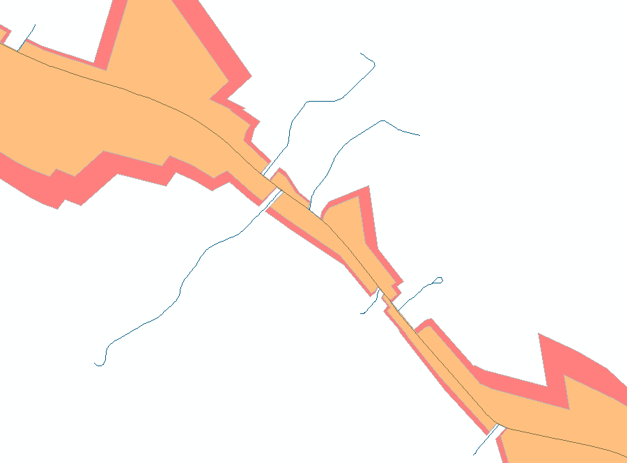
I'll attach a photo below.
Solved! Go to Solution.
Accepted Solutions
- Mark as New
- Bookmark
- Subscribe
- Mute
- Subscribe to RSS Feed
- Permalink
- Report Inappropriate Content
Your streets have to be more than just "physically" connected to other streets in the network in order for those connections to be routable. If your network has End Point connectivity, the streets have to touch at end points or else they will not be treated as connected. If your network has Any Vertex connectivity, the streets have to touch at either an end point or a vertex. Read more about network dataset connectivity policies here: Understanding connectivity—Help | ArcGIS for Desktop
- Mark as New
- Bookmark
- Subscribe
- Mute
- Subscribe to RSS Feed
- Permalink
- Report Inappropriate Content
The obvious question, is are they actually connected to the network, or just look like they are?
- Mark as New
- Bookmark
- Subscribe
- Mute
- Subscribe to RSS Feed
- Permalink
- Report Inappropriate Content
Hi Dan, I physically checked some of them (there are hundreds of holes) and they seem to be connected.
- Mark as New
- Bookmark
- Subscribe
- Mute
- Subscribe to RSS Feed
- Permalink
- Report Inappropriate Content
Grief... I vaguely remember something about the rules in the setup, about dead end rules and uturns, but I am not sure, but have a look
- Mark as New
- Bookmark
- Subscribe
- Mute
- Subscribe to RSS Feed
- Permalink
- Report Inappropriate Content
Thanks for your help Dan, I think you're on to something with your first answer.
- Mark as New
- Bookmark
- Subscribe
- Mute
- Subscribe to RSS Feed
- Permalink
- Report Inappropriate Content
Your streets have to be more than just "physically" connected to other streets in the network in order for those connections to be routable. If your network has End Point connectivity, the streets have to touch at end points or else they will not be treated as connected. If your network has Any Vertex connectivity, the streets have to touch at either an end point or a vertex. Read more about network dataset connectivity policies here: Understanding connectivity—Help | ArcGIS for Desktop
- Mark as New
- Bookmark
- Subscribe
- Mute
- Subscribe to RSS Feed
- Permalink
- Report Inappropriate Content
Hi Melinda,
Thanks for your input. Let's say the problem IS connectivity, do you know if there is a tool that would identify points where lines are not connecting?
Thanks.
- Mark as New
- Bookmark
- Subscribe
- Mute
- Subscribe to RSS Feed
- Permalink
- Report Inappropriate Content
Well...your Service Area analysis did a pretty good job of identifying roads that weren't connected.
If you're using Any Vertex connectivity, you can automatically add vertices at locations where roads cross using the Integrate tool with 0 XY tolerance. Make a backup copy of your data first...
If you're using End Point connectivity, you'll have to split features at intersection points, which can be done. However, if you have fields in your data like address ranges or travel times, keep in mind that these could get messed up if you start splitting features. You'll need to make sure that your geodatabase domains are set up with the appropriate merge/split policies.
- Mark as New
- Bookmark
- Subscribe
- Mute
- Subscribe to RSS Feed
- Permalink
- Report Inappropriate Content
Is it a featureclass that was used as input? with topology? An overview of the File Geodatabase toolset—Help | ArcGIS for Desktop and the 2nd obvious question, everything is in one layer?
- Mark as New
- Bookmark
- Subscribe
- Mute
- Subscribe to RSS Feed
- Permalink
- Report Inappropriate Content
The quick and dirty workaround to identify gaps in a theoretically connected Network Dataset is to use Network Analyst to create a New Service Area. When setting up the Service Area, check off the box to Generate Lines.
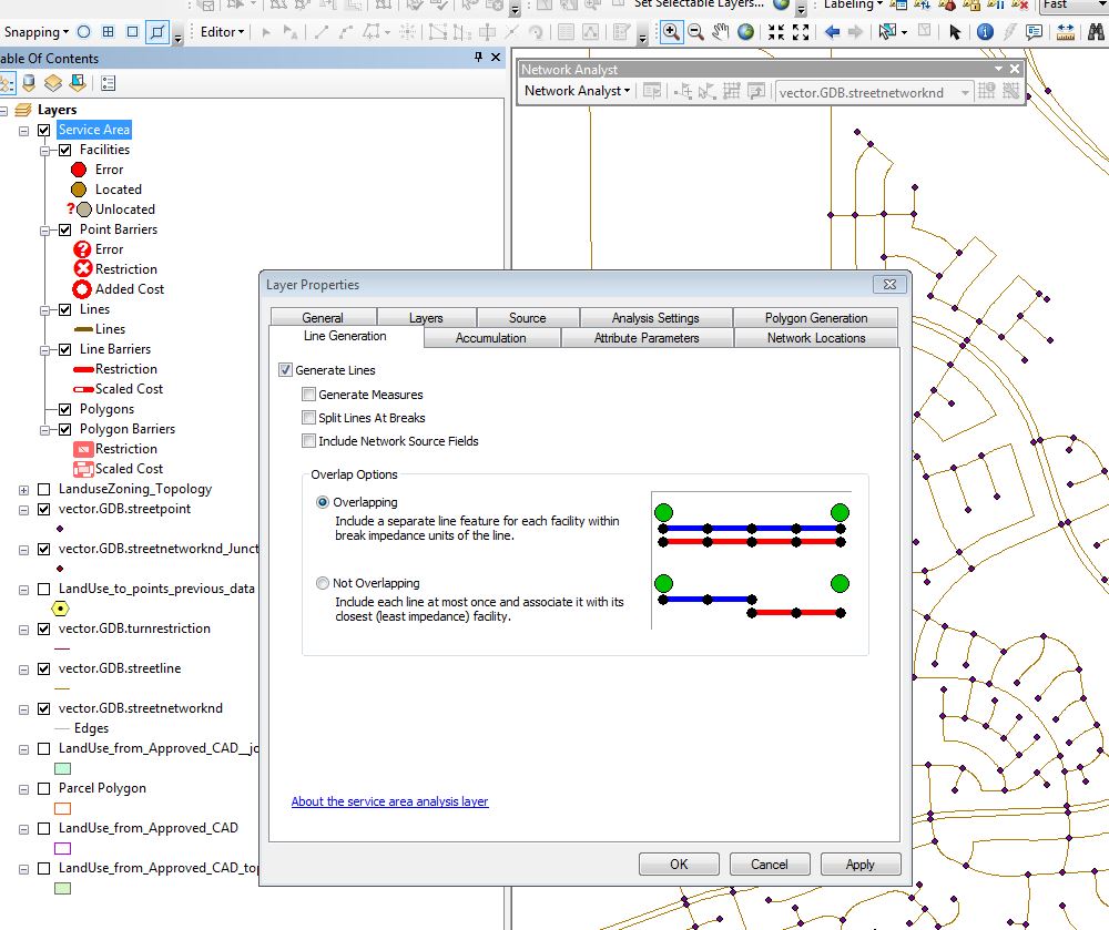
Then set the Default Breaks on the Analysis Settings tab to a very large value so the entirely street dataset will definitely be covered.
Then run it. If lines are not generated across your entire network dataset, then there are issues with connectivity. My guess given the image you have posted is that there are tiny disconnects at each of the intersections.
Chris Donohue, GISP
Network Analysis = 1% Analysis + 99% Data Cleanup