- Home
- :
- All Communities
- :
- Products
- :
- ArcGIS Online
- :
- ArcGIS Online Questions
- :
- Re: Arc GIS Online Crowd Sourcing App
- Subscribe to RSS Feed
- Mark Topic as New
- Mark Topic as Read
- Float this Topic for Current User
- Bookmark
- Subscribe
- Mute
- Printer Friendly Page
- Mark as New
- Bookmark
- Subscribe
- Mute
- Subscribe to RSS Feed
- Permalink
- Report Inappropriate Content
Hello,
I created a crowd sourcing app using the Crowd Sourcing App from ESRI in ArcGIS Online. The public comment phase is over, and now our organization is reviewing the results of the application and how we would like to improve for next years public comments. Here is the link to the instructions for the app that I used:
One of the issues that I found was that the comments were very difficult to get from online to a local environment so that the organizations groups that needed to review the comments could have them in a spreadsheet format. Although I was able to make this work, there were no instructions on how to make that happen as part of the app instructions.
What was more problematic was that there was no identifier in the downloaded comments to link back to the projects. This had to be completed manually (by a stake holder that really wanted the feedback). In other words;
- The public comments were for road projects that were in a line feature
- Public users clicked on a project and were able to leave comments about that project
- To review the comments in the app a user just clicked on the project and was able to see all the comments associated with the project selected
- However, when the data from the table was downloaded there was no way to link the comments back with a project. There was a related table associated with the line feature.
What I am wondering is if I made an error in creating the app (in the online version the comments were linked to the location and it was not a problem) and I just needed to configure the app differently?
Thanks in advance for any insight you can provide,
Gail
Solved! Go to Solution.
Accepted Solutions
- Mark as New
- Bookmark
- Subscribe
- Mute
- Subscribe to RSS Feed
- Permalink
- Report Inappropriate Content
Hi Allison,
I did put a ticket in with ESRI Support and the resolution to the problem is to export the data to a file geodatabase. Once the data is exported to a file geodatabase the relationship is maintained in the export (I had exported to shapefile or table and the relationship was not being maintained). When the layer file and the table are brought in to ArcMap a join was created from the table to the line layer. Then I was able to export the table to a spreadsheet with the correct comments associated to the correct location attribute which was in the line layer.
Thanks for your comments.
Gail
- Mark as New
- Bookmark
- Subscribe
- Mute
- Subscribe to RSS Feed
- Permalink
- Report Inappropriate Content
Information on exporting data from AGOL layers can be found here: Use hosted layers—ArcGIS Online Help | ArcGIS
When the feature layer is correctly connected to the comments table through a relationship class, every incoming comment will automatically have a field calculated with an identifier that corresponds to an attribute value of the related feature. The field on feature layer that is the source of these values (primary key field) and the field in the table that is populated with these values (foreign key field) are determined when the relationship class is created. Typically this is a Global ID/GUID field, but it may also be a Project Name field, or other identifier that is unique to every feature.
If the correct comments were displaying with the correct features in the Polling app, this was set up correctly. This also means that every comment can be associate with it's target feature using the values in these primary and foreign key fields.
- Mark as New
- Bookmark
- Subscribe
- Mute
- Subscribe to RSS Feed
- Permalink
- Report Inappropriate Content
Hi Allison,
I appreciate your comments. I double checked with the manager that was reviewing the comments to confirm that the comments were consistent with the project selected in the online app, and he said that was how he will able to go back and reference a project number to a comment, so that indeed worked.
The next step is where things fall apart. I am able to export the feature class to a shapefile and download to my desktop. When I open the feature class I see 302 records which is exactly the number of records when I published. I am also able to download the table using the same process. When I open the related table that I downloaded from AGOL, there are 302 records that same number of records that are in the feature layer.
I was able to get the comment records from the related table by doing some analysis and then exporting. If you are interested in seeing that I can post the instructions, but it was not a straight download from the table in the map.
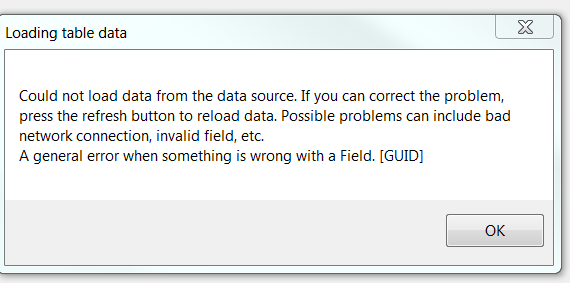
I have also tried opening the maps that is published to AGOL in the desktop ArcMap, and this error message occurs:
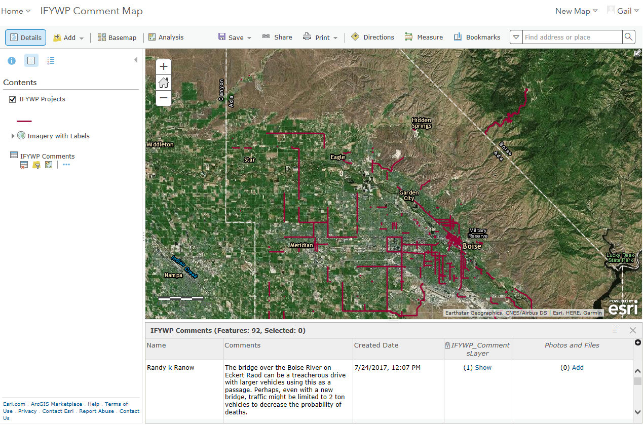
Here is a screen shot of the AGOL web map:
Any ideas that you may have about how to get the comments into a spreadsheet format with some identifier would be greatly appreciated!!
Regards,
Gail
- Mark as New
- Bookmark
- Subscribe
- Mute
- Subscribe to RSS Feed
- Permalink
- Report Inappropriate Content
Hi Gail,
I'm not able to reproduce the issue you are running into.
When I export a hosted feature layer to a shapefile following the directions I posted above, the exported shapefile contains two layers - one for the reports and one for the comments. I can associate the records in both of these using the fields I used to set up the relationship before publishing the layer.
This is much easier if I export to geodatabase because the relationship is included in the export, but it works either way.
If you continue to see this error, try contacting Esri Support services. This should be working, and exporting and associating these records should be straight-forward.
-Allison
- Mark as New
- Bookmark
- Subscribe
- Mute
- Subscribe to RSS Feed
- Permalink
- Report Inappropriate Content
Hi Allison,
I did put a ticket in with ESRI Support and the resolution to the problem is to export the data to a file geodatabase. Once the data is exported to a file geodatabase the relationship is maintained in the export (I had exported to shapefile or table and the relationship was not being maintained). When the layer file and the table are brought in to ArcMap a join was created from the table to the line layer. Then I was able to export the table to a spreadsheet with the correct comments associated to the correct location attribute which was in the line layer.
Thanks for your comments.
Gail
- Mark as New
- Bookmark
- Subscribe
- Mute
- Subscribe to RSS Feed
- Permalink
- Report Inappropriate Content
Hi Gail,
Thanks for reporting back! I'm glad you were able to get this resolved.
-Allison