- Home
- :
- All Communities
- :
- Products
- :
- ArcGIS Online
- :
- ArcGIS Online Questions
- :
- Cluster Points function is not available in ArcGis...
- Subscribe to RSS Feed
- Mark Topic as New
- Mark Topic as Read
- Float this Topic for Current User
- Bookmark
- Subscribe
- Mute
- Printer Friendly Page
Cluster Points function is not available in ArcGis online map
- Mark as New
- Bookmark
- Subscribe
- Mute
- Subscribe to RSS Feed
- Permalink
- Report Inappropriate Content
When using Maps for Office there is a button called "Cluster Points" as shown below. That's a very useful function.
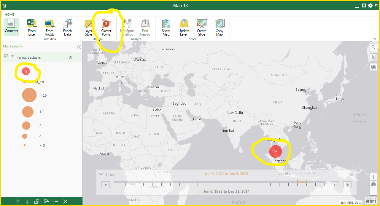
After I click on the button and send this layer to ArcGIS Online, I then open the map online (in the ArcGIS online Map Viewer) and do not see the clustering anymore. Any ideas how do I get it back?
Solved! Go to Solution.
Accepted Solutions
- Mark as New
- Bookmark
- Subscribe
- Mute
- Subscribe to RSS Feed
- Permalink
- Report Inappropriate Content
Mina,
I did not know that the ArcGIS Maps for Office had a cluster option. And you're completely right, this would be extremely useful in AGOL.
I have always relied on custom JavaScript to make clustering happen:
Point clustering | ArcGIS API for JavaScript 3.17
I also stumbled upon this GitHub code for clustering (which also uses JavaScript):
GitHub - Esri/cluster-layer-js: One example of how to cluster many point features
I would suggest making an ArcGIS Idea for this but there are several other ideas out there for clustering and fortunately, this is being considered. You can go here and help vote the idea up:
- Mark as New
- Bookmark
- Subscribe
- Mute
- Subscribe to RSS Feed
- Permalink
- Report Inappropriate Content
Thanks Adrian, I voted the idea up, it seems it's been there since 2012 and nothing has happened 
The problem with JavaScript approach is that I'm creating a web app that's hosted on ArcGIS online and once I start using JS I need to host the web app my self - which I don't want to do.
- Mark as New
- Bookmark
- Subscribe
- Mute
- Subscribe to RSS Feed
- Permalink
- Report Inappropriate Content
Flagging Don Opgenorth to perhaps direct the request
- Mark as New
- Bookmark
- Subscribe
- Mute
- Subscribe to RSS Feed
- Permalink
- Report Inappropriate Content
Hi Adrian,
Could you give us some hints about how to implement the GitHub code for clustering ?
I can run it locally but I have no ideas about how to add and apply it to layers of my own web application.
Thanks.
Alex.
- Mark as New
- Bookmark
- Subscribe
- Mute
- Subscribe to RSS Feed
- Permalink
- Report Inappropriate Content
Alex,
I have not used the GitHub code. I only mentioned that I stumbled across it and wanted to reference it as an example. What issues are you having? Where is your web map hosted? In order to be able to see your data on the web, it needs to be on a server somehow. Can you give some more details on your set up?
- Mark as New
- Bookmark
- Subscribe
- Mute
- Subscribe to RSS Feed
- Permalink
- Report Inappropriate Content
Hi Adrian,
Thanks for your answer. That would be difficult to see the data on the web because everything is locked on our local network. However, what I want to do is simple:
- I've a basic web application with point layers
- That would be good if I could apply clustering to one of these layers
- The widget provided by ESRI is useless for me and that piece of code would be great
But anyway I'm already stuck with the example posted on GitHub. It works with the defaults parameters but not with my local service (I've posted a question there).