- Home
- :
- All Communities
- :
- Products
- :
- ArcGIS Online
- :
- ArcGIS Online Questions
- :
- Coordinate System: Going Online
- Subscribe to RSS Feed
- Mark Topic as New
- Mark Topic as Read
- Float this Topic for Current User
- Bookmark
- Subscribe
- Mute
- Printer Friendly Page
Coordinate System: Going Online
- Mark as New
- Bookmark
- Subscribe
- Mute
- Subscribe to RSS Feed
- Permalink
- Report Inappropriate Content
Hello everyone. I am using ArcGIS Pro 3.1.2. I am trying to share a web map, I made a copy of the map I use primarily to test out sharing a web map. We use NAD 1983 in our primary map, but when I attempted to share the copied map to the web, I received errors, needing to select a basemap, than I had to keep the same projection throughout the map, ultimately matching my basemap, WGS 1984.
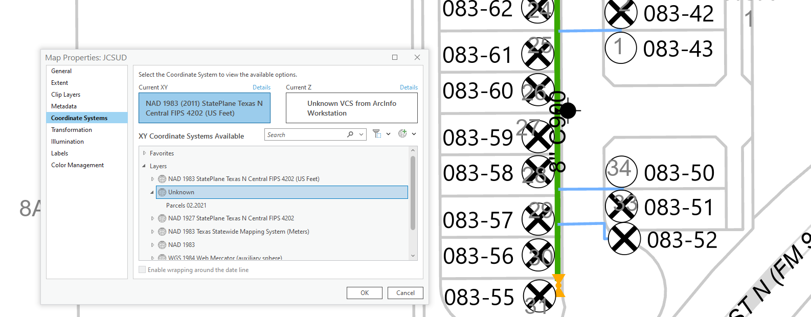
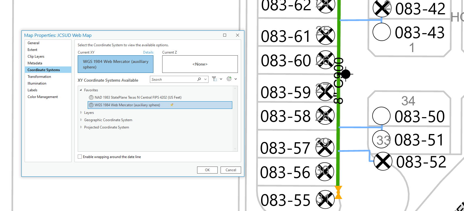
Pictured, is the primary map in NAD and the copy in WGS. When I make edits or move points in my map, they also move in the copy. Another thing is, in my primary, the points are tight and uniform, as I have spent a lot of time making points uniform. In the other map, the points do not appear that way, and when I attempt to adjust them in the copy, it also moves the points in my primary, appearing not uniform. How can I maintain that uniform look, while also making the necessary adjustments to the projection? Is there any way to share as NAD with a NAD basemap? Or a way to go to WGS without such a big difference in position? I think the changes are reflected in both places because the layers share the geodatabase, would I be better off making an entirely different map with shapefiles or something instead of sharing geodatabase? Help pls, thanks!
- Mark as New
- Bookmark
- Subscribe
- Mute
- Subscribe to RSS Feed
- Permalink
- Report Inappropriate Content
First of all, there are a lot of things going on here. ArcGIS Online web maps will always default to the WGS 84 Web Mercator projection by design. In order to use a different coordinate system, you need to publish to a portal on enterprise.
Your NAD83 system (if instantiated appropriately) should reproject on the the fly to WGS 84 when you publish to the AGOL. What is the error message you are getting when you try publishing? Can you post a screen shot of that?
Secondly, what do you mean by tight and uniform? In your first screenshot, it looks like one of your layers is in an unknown coordinate system so that could be one of your issues. Your layers need to be in a coordinate system that can be reprojected in order to be published to AGOL. Going from gdb to shapefile should not make a difference.
Thirdly, what all are you trying to publish? It looks like you might have annotations or graphics layers on your maps?
- Mark as New
- Bookmark
- Subscribe
- Mute
- Subscribe to RSS Feed
- Permalink
- Report Inappropriate Content
- When I first attempted to share the primary map as a web map, while I have the world imagery basemap in, it just said I needed to have my map layers match projection of the basemap. So I did, and then I saw the shift in points and was able to publish without an issue.
- By tight and uniform, I mean the way the points are aligned. In the NAD (first) screenshot, the points are close together, in pairs of 2, closely lined with the tracts or polygons pictured. In the other screenshot, WGS, the points are more spaced out.
- My labels pictured here are made with the Maplex label engine (I hope I am phrasing that right). I don't believe I have any graphics or annotation..... I have shared as web map before and didn't have any issues with label (sorta) but issues with projection. What all I am trying to publish, is an entire web map with an exploratory configuration. I also used tile layers to mimic my own basemap, but still would like to get my points/projection to look like it does in my primary (NAD) map.
How does one publish to a portal on enterprise? Publish what? I have made my own basemap and shared it to a group on AGOL.... but I don't think that is what you are referring to. (Please excuse any lack of my own understanding)
- Mark as New
- Bookmark
- Subscribe
- Mute
- Subscribe to RSS Feed
- Permalink
- Report Inappropriate Content
Are your points and polygons in the exact same coordinate system as each other in your NAD map?
Labels in ArcGIS Online have come a long way but will still lack full-desktop-functionality. Meaning that, they will get 'dumbed down' when they go from desktop to AGOL. It will be somewhat difficult to make everything look exactly the way you want from desktop to online, just because of the nature of this process. Sometimes, I have even "cheated" by making all my labels and annotations into actual lines instead of text and published that (but that is usually too much work).
To publish to portal on enterprise, you have to have this service (and by publish, it's the same as AGOL - a web map with feature layers that goes to a web service). Most large organizations and most government agencies have an enterprise environment where they publish their data to instead of an AGOL environment (and most use both). The benefits of it are having custom labels and symbology, different coordinate systems, you host/manage your own data, increased security, etc. to name a few. Though, it obviously comes with a higher price tag and much more maintenance/expertise.
I am not fully sure what you want to accomplish with your map but this is what I would do. I would absolutely make sure that all my data layers that I put on the web are in the exact same coordinate system (along with the map). I would only put those data layers I want to see published into my map and just publish that alone to ArcGIS Online. Then in AGOL, examine and make adjustments based on what needs to happen. I often work with surveyors who get really bent out of shape when things are "measured" properly. So, the maps I make for them in AGOL have to come with a caveat/disclaimer that it will be in WGS84 and things may be slightly skewed. I have even had to pre-load measurement data in the proper system as attributes to suffice this. Another option is to do what you did with the WGS84 map but make them separately in separate geodatabases so you don't mess the original up (and then make sure it looks good before publishing to the web).