- Home
- :
- All Communities
- :
- Products
- :
- ArcGIS Online
- :
- ArcGIS Online Questions
- :
- Re: Feature Layer style not rendering from ArcGIS ...
- Subscribe to RSS Feed
- Mark Topic as New
- Mark Topic as Read
- Float this Topic for Current User
- Bookmark
- Subscribe
- Mute
- Printer Friendly Page
Feature Layer style not rendering from ArcGIS server rest service
- Mark as New
- Bookmark
- Subscribe
- Mute
- Subscribe to RSS Feed
- Permalink
- Report Inappropriate Content
In AGOL, if I add the public service:
Landgate_Public_Maps/Locate_2_0 (MapServer)
All layers are styled correctly in the map viewer. However, if I add an individual Layer from this service using it's REST endpoint, e.g.:
Layer: Local Government Authority (LGA) Boundaries (LGATE-006) (ID: 30)
The layer's style does not render correctly in the map viewer.
I've tested this same method with other REST services and the styles render correctly. Is there anything I can request the service provider to do on their end to fix this? Or is there something I can do?
Jason
- Mark as New
- Bookmark
- Subscribe
- Mute
- Subscribe to RSS Feed
- Permalink
- Report Inappropriate Content
Hm, the REST endpoint does show that the renderer matches what we see in the map viewer when just using the feature layer:
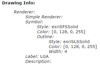
I wonder if it's something specific to the renderer that can't be drawn outside of an export map request. Can you post the URL to the layer that works correctly?
- Mark as New
- Bookmark
- Subscribe
- Mute
- Subscribe to RSS Feed
- Permalink
- Report Inappropriate Content
Hi Jonathon, here is an example of a layer from that service that works correctly:
Layer: Road Hierarchy (MRWA-515) (ID: 21)
Cheers
Jason
- Mark as New
- Bookmark
- Subscribe
- Mute
- Subscribe to RSS Feed
- Permalink
- Report Inappropriate Content
So it looks like the feature type and how it's rendered are related to the problem. Most polygon feature layers don't honor the symbology, but some do. If it's not your service, there's not much you can do on the service end. What client are you using? You can update the symbology for the layer in the client application. The following example is a web map:

- Mark as New
- Bookmark
- Subscribe
- Mute
- Subscribe to RSS Feed
- Permalink
- Report Inappropriate Content
Thanks Jonathon,
I've raised this issue with the service provider, so hopefully they can rectify it.
I realize I can change the symbology in AGOL Map Viewer, thanks.
Cheers,
Jason