- Home
- :
- All Communities
- :
- Products
- :
- ArcGIS Online
- :
- ArcGIS Online Questions
- :
- Re: Tiled image in ArcGIS Online does not let me z...
- Subscribe to RSS Feed
- Mark Topic as New
- Mark Topic as Read
- Float this Topic for Current User
- Bookmark
- Subscribe
- Mute
- Printer Friendly Page
Tiled image in ArcGIS Online does not let me zoom in far
- Mark as New
- Bookmark
- Subscribe
- Mute
- Subscribe to RSS Feed
- Permalink
- Report Inappropriate Content
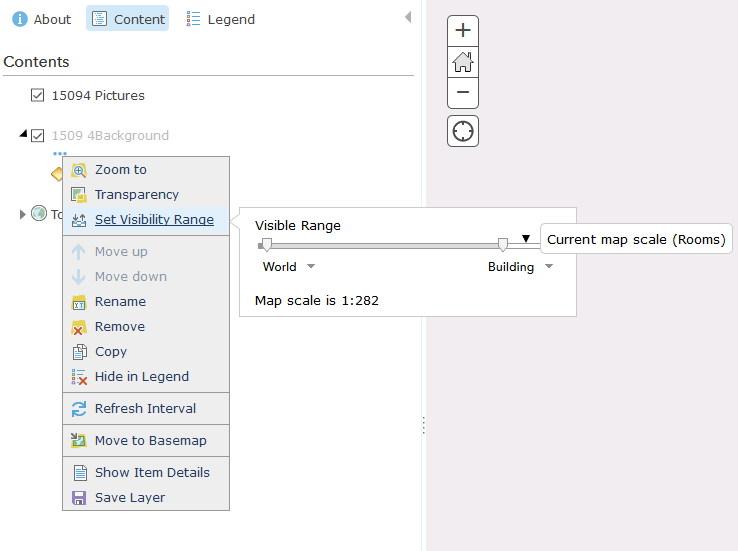
I have published a tiled image and I have set the visibility range to the max. However, it doesn't stay. Take a look:
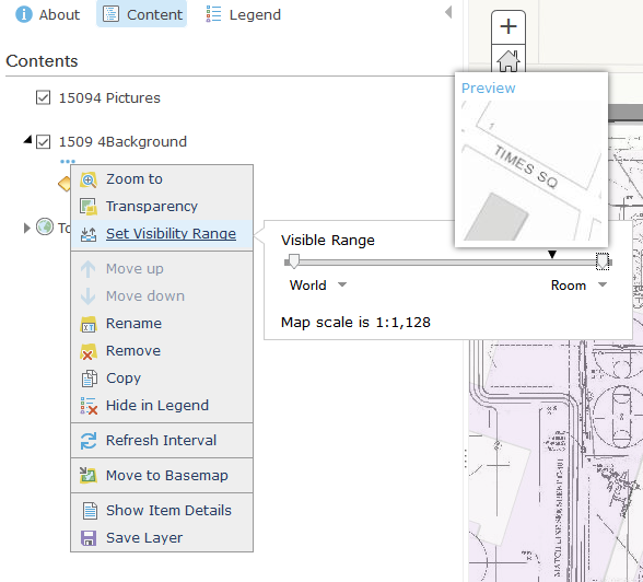
But, as soon as I set it, and zoom it, it changes back to its own preset default for no good reason. Is there any way around this? Is this a bug in ArcGIS Online?
Please help!
A link to the web map: http://arcg.is/2fouTew
Solved! Go to Solution.
- Mark as New
- Bookmark
- Subscribe
- Mute
- Subscribe to RSS Feed
- Permalink
- Report Inappropriate Content
Hi Kelly:
How about under Portal and with an Image Server service?
I recently published our 2016 ortho-imagery to an Image Service on a 10.4.1 AGS box.
Then shared that to our portal.
But that image service then doesn't display below level 19 (1:1128)
The Esri imagery basemaps do show down below Level 19, but they aren't tiled there, it's just resampling, correct?Which is fine....
Basically, what I need to do is:
Displaying Dynamic and Tiled layers
But that details for the map service method and not the image service.
Is there a similar page out there?
No luck with Goggle or Geo-Net yet.
- Mark as New
- Bookmark
- Subscribe
- Mute
- Subscribe to RSS Feed
- Permalink
- Report Inappropriate Content
Hi Paul,
What basemap are you using? Does the entire web map not zoom past level 19 or does the image service data disappear when the web map zooms in beyond level 19?
-Kelly
- Mark as New
- Bookmark
- Subscribe
- Mute
- Subscribe to RSS Feed
- Permalink
- Report Inappropriate Content
Hi Kelly: Somehow I missed your response from November. Sorry for my delay.
I do have a very basic question just to make sure I understand the issue and what can be done:
If you publish a tiled & cached image service, can that same image service be setup to dynamic deliver imagery for layers that the mxd supports but that are not Cached in the Image Service?
I think that is the basic question being discussed in this thread? Or have I misinterpreted things.
Wouldn't be the first time. 😉
And the other basic question, if the answer above is Yes, does this apply to Portal and ArcGIS 10.5 Image Servers
I may not have explained my issue properly.
Basically, I am trying to get a locally published Image Service, which is now on a dedicated 10.5 ImageServer, that is cached and tiled down to Level 19 (counting from Level 0) This is a 1:500 Scale.
So in other words, I added one more level beyond the "stock" 19 levels.
When this layer is active, if I zoom in closer than the 1:500 scale, my locally published imagery stops displaying.
It will only display at levels for which I created the cache.
The Esri Imagery basemaps keep on displaying for as long as I can zoom in.
It seems obvious that the Esri imagery basemaps are resampling down below ~1:1000
(I would guess that is the actual resolution of the imagery.)
I want to get our Tiled/Cached Imagery to do behave like this.
I'll cache it down to the source resolution and then let it resample down below that.
so far, I think all the info on this thread has been related to AGOL and not Portal.
I believe your response below to Kalen but with the URL adapted for Portal is the info I need?
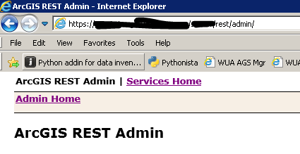
But I am missing something on getting to the rest admin site for our new 10.5 Image Server.
I can go here:
https://MyFQDN/MyWAName/rest/admin/
and not pull an error. But I only get a 98% blank page.
all I see is the following:
When I try to go to the specific tiled service's rest admin point, for example:
https://MyFQDN/MyWAName/rest/admin/services/Aerials_2016_StatePlane/ImageServer/edit
I pull a 400 error, Invalid URL
I've tried a few things to add in tile info to URL but so far no luck.
Thanks for you help!
- Mark as New
- Bookmark
- Subscribe
- Mute
- Subscribe to RSS Feed
- Permalink
- Report Inappropriate Content
I am not sure that I am seeing what I should be seeing. When I am logged in and browse to that url (with the edit word at the end), this is what I see:
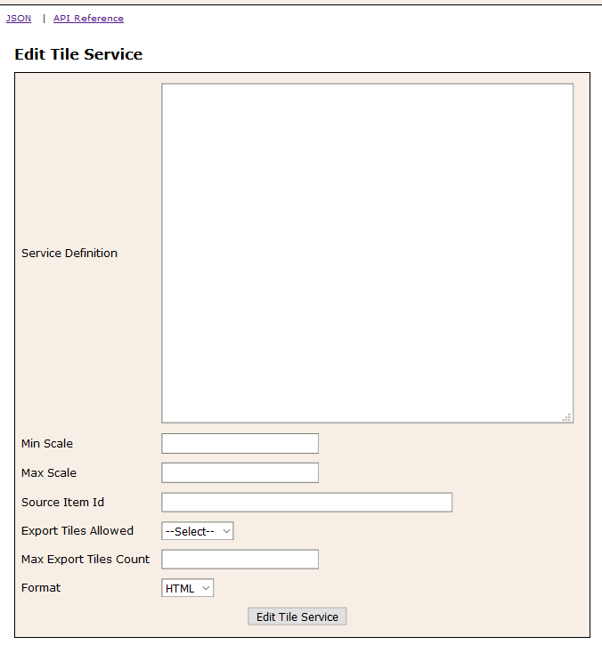
Do I type in the {"resampling":true} into the Service Definition box and click on the Edit Tile Service below? Or do I need to find this somewhere else? I just don't want to mess it up if I am doing it incorrectly.
(I guess I assumed that I would be seeing json-like text and would see something like 'resampling:false' and I would just change that false to true...)
(for instance, when I look at the json part of this service, I see:
"sourceType" : "SERVICEDEFINITION", "maxExportTilesCount" : 100000, "exportTilesAllowed" : false, "count" : 4931, "readonly" : null, "resampling" : null, "jobStatus" : "DONE", "currentJob" : "b742961772a90abc", "type" : "MapServer"
at the bottom. I cannot edit this, that I am aware of.)
- Mark as New
- Bookmark
- Subscribe
- Mute
- Subscribe to RSS Feed
- Permalink
- Report Inappropriate Content
Hi Adrian,
Add the text into the edit box just as you described above. Once you have enabled tile resampling, a parameter will appear in the rest endpoint. If you turn tile resampling off, {"resampling":false}, no mention of the parameter will be visible in the rest endpoint.
Here is an example service with resampling turned on.
-Kelly
- Mark as New
- Bookmark
- Subscribe
- Mute
- Subscribe to RSS Feed
- Permalink
- Report Inappropriate Content
Wow, this completely fixed a separate issue I was having with browser cache, as well as made my image look crisper.I may write a blog post about this just so I can chronicle what steps I took, etc.
Thanks so much, Kelly, for this suggestion!
- Mark as New
- Bookmark
- Subscribe
- Mute
- Subscribe to RSS Feed
- Permalink
- Report Inappropriate Content
Hi! Have you written that blog post?  I can't seem to access the admin directory for my service. I can get to the normal service directory easily enough by following the URL for my service, but I can't figure out how to edit it.
- Mark as New
- Bookmark
- Subscribe
- Mute
- Subscribe to RSS Feed
- Permalink
- Report Inappropriate Content
Hi Kalen,
What url are you navigating to to access the admin directory?
-Kelly
- Mark as New
- Bookmark
- Subscribe
- Mute
- Subscribe to RSS Feed
- Permalink
- Report Inappropriate Content
Hi Kelly,
I tried accessing the directory from the URL on the item details page. This takes me to the "Services Directory". I'm missing how to get to the "admin directory".
Thanks for your help!
- Mark as New
- Bookmark
- Subscribe
- Mute
- Subscribe to RSS Feed
- Permalink
- Report Inappropriate Content
@Kalen_Myers
There is a post above that explains this, but here are the instructions of accessing the admin directory:
To do this,
1. Navigate to the admin directory of the published service:
https://tiles.arcgis.com/tiles/<org-id>/arcgis/rest/admin/services/<service-name>/MapServer/edit (You will be prompted to login. This login has a case sensitive username so be aware of the case of your username)
2. In the Edit dialog box, set the following Service Definition Parameter: {"resampling":true}
REST API documentation: http://resources.arcgis.com/en/help/arcgis-rest-api/index.html#/Edit_Service/02r300000222000000/